Clicking leads to bigger photos
South-eastern side of Rileys Island
Rileys was once inhabited by a single family. The Rileys. They bought it in 1855 and built a house there and an oyster farm nearby. The house is long gone. Rileys is now a nature reserve and home to various birds and beasts and plants. The family still lives in the area.

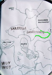
(The ferries crowd won't mind me nicking their map, I link them often enough)
Rileys Island is the green one just above St Huberts, the one with all the blasted canals.
Can't find it? Map with Rileys marked and another one.
There's not a lot of aerial views of Rileys. This one of St Huberts & most of Rileys looks like the best. You can clearly see the mangroves and the schlerophyll forest bits.

St Huberts Narrows between St Huberts (left) & Rileys Islands
A ferry will fit through there, as the ferries map above shows in a dotted line.

1901, St Huberts marked with red dot, Rileys above it
Rileys is not the only uninhabited island in Brisbane Water. All up, there's nearly a dozen islands and islets. Only St Huberts is inhabited by humans. Some of the islets are so tiny they are in danger of being washed away with the king tides.
The islands are pretty stable. They are Pelican Island, St Huberts Island (inhabited) and Rileys Island. You can see in the old maps they've changed shape a bit over time but there till there.
Rileys Stats
* Sold in 1855 as Shell Island to John Riley for 140 pounds, 17 shillings & sixpence
* 45 hectares in area (0.17 square miles in American)
* A ship called the Maggie Riley built there in 1878
* Two or three other ships built there in the 1860s
* The Riley family's oyster farm had "large slabs of flat ashlar stone...[stood] upright in the shallows near Riley's Bay"
* They also had "a few cattle [and] a banana plantation, using seaweed for fertiliser", on the island (History of Woy Woy)
* The island was made into a park June 1989
* Its flora (plants & trees) is mangrove swamp round the edges and dry schlerophyll forest in the middle
* The mangroves are Avicennia marina (Grey Mangrove) and Aegiceras corniculatum (River Mangrove)
* Before before us whitefellas came, the food available on and near Rileys was stuff like "shellfish, fruit, tubers, insect larvae, snakes, lizards and small animals...and speared fish with multi-pronged fish spears tipped with fish teeth or bones...Shellfish middens were so large that they were later excavated for a local lime burning industry that supplied lime for building works in Sydney." (Historical info on the Illoura Walk at Davistown)
Map showing main area of mangroves & adjacent oyster farms

St Hubert's & Riley's Islands
Check out the bridge sketched in between St Huberts (lower) and Rileys (cut off island). They were gonna canal Rileys as well as Huberts.
"During the 1960s efforts were made by Hooker-Rex Estates to develop canal subdivisions on both Riley’s Island and the adjoining St. Hubert’s Island. The latter island was eventually developed for residential use in the early 1970s, but a major environmental battle was waged to preserve Riley’s Island. This was ultimately successful, and Riley’s Island is now a sanctuary supporting a wide variety of fish and bird life." (History of Davistown includes 1854 map)

Rileys Island from Morton Crescent Davistown

St Huberts & Rileys Islands from Blackwall Mountain
The reason I haven't shown you a photo of the whole of Rileys is the bastard is so hard to photograph. Even when you get a clear shot at it, the bastard melts into the background. It's not much easier to see with the naked eyeball. You gotta know what you're looking for.
Anyways, it's a bloody lovely bit of nature and I'm glad it wasn't canal'd and built on.