Showing posts with label Bustling Downtown Woy Woy. Show all posts

Friday, April 24, 2009

Lone Pine

(Random walkies)

Woy Woy Memorial Park 24th April 2009

Australia and New Zealand hold memorial services for the war dead on ANZAC Day. It's like Memorial Day in America or Poppy Day in the UK. ANZAC stands for Australian & New Zealand Armed Corps.

In World War I the Anzacs fought a series of terrible battles in appalling conditions against Turkey at Anzac Cove in Gallipoli. Many of our boys died there and still lie there in Turkish soil. The Turks look after them for us along with their boys.

(To my mate currently serving in the Middle East: Don't get shot at, pet, and enjoy all that khaki crumpet.)


Rosemary in Woy Woy Memorial Park

Rosemary is for remembrance.


Pinus halepensis AKA Lone Pine

It says:

"Pinus halepensis

Lone Pine or Plateau 400 was the scene of a major diversionary offensive launched by the 1st Australian Infantry Division on 6 August 1915. The Turks had cut down all but one of the trees that covered the ridge to clothe thrie trenches. The ridge dominated by the single Allepo Pine (Pinus halepensis) became known as Lone Pine. In three days of fighting the Australians lost more than 2000 men and the Turks losses were estimated at 7000. Seven Victoria Crosses were awarded.

As far as we know two Australian soldiers souvenired pinecones from the ridge that found their way back to Australia.

Lance Corporal Benjamin Smith of the 3rd Battalion, whose brother was killed in the battle for Lone Pine, sent a come home to his mother, Mrs McMullen at Inverall New South Wales. Mrs McMullen kept the cone for 13 years before planting the seeds in 1928. She grew two seedlings, one of which she presented to the town of Inverall and the other to the Parks and Gardens section of the Department of the Interior in Canberra. The Duke of Gloucester planted this second tree at the Australia War Memorial in October 1934. Today iot stands over 20 metres in height.

SGT Keith McDowell of the 24th Battalion carried a pinecone in his haversack until the end of the war. Upon returning home to Australia he gave it to his aunt, Mrs Emma Gray, who lived at Grassmere near Warmambool, Victoria. A decade or so later Mrs Gray planted the seeds and [unknown word] seedlings were grown. One was planted in May 1933 at Wattle Park, Melbourne. Another at the Shrine of Remembrance, Melbourne and another at the Soldiers Memorial Hall at The [unknown word]. The last was planted in the Warmambool Gardens.

In 1990 two trees were taken back to Gallipoli with war veterans who attended the memorial service to mark the anniversary of the battle of Lone Pine.

Since the 1980s many trees have been grown by seed and grafting techniques from the tree at the Australian War Memorial. This tree is one of those trees."


Lone pine, Woy Woy War Memorial Park

The photo above is of the marker under this tree. "This tree is one of those trees."

More on Anzac Day at the Ducktionary

The Woy Woy Dawn Service will be at the memorial park on Brick Wharf Road next to the blue fish and chip shop. The march starts at 10.30am from the carpark of Deepwater Plaza, George Street near Railway Street in yer street directory.

Saturday, April 18, 2009

Pelican Island

If you live in Woy Woy you can't not know Pelican Island. It's right there opposite the ferry wharf, about as far across the water as a seagull can spit, barely a hundred yards from the train station and Bustling Downtown Woy Woy.

But hardly anyone ever goes there. It's uninhabited, except by pelicans and trees. And mozzies (mosquitoes). Fucking squadrons of the bastards! We were eaten alive, even with the bloody repellant slathered on like cream on cake.


Pelican Island

As you can see in the in-set map, Pelican Island is actually two islands with a narrow channel running between them. Another narrow channel, a dead end, runs into the interior of the larger island. (In-set map borrowed and modified from the local ferry crowd.)


Mangroves on Pelican Island Woy Woy

There's a few tiny wee beaches for landing on the island. The biggest is maybe ten metres long. That's about 33 feet in American. Give or take.


Mangroves, Pelican Island Woy Woy

The rest of the shore is thick with mangroves. Those white lumps on the mangroves roots are rock oysters.


Casuarinas & mangroves Pelican Island Woy Woy

A few feet from the shore and the casuarina trees (left) start. The other name for them is she-oaks. They have needles instead of leaves, not smooth but with tiny segments like bamboo. (Close-up of needles) When the wind whispers through them it gives a soft whispery howl.


Pelican Island Woy Woy

The island is made of sand and can't be more than a metre (about 3 feet) above sea level at high tide. We could see where big waves or king tides had swept sea grass and floating stuff up over the wee beach and several metres inland.


Pelican Island Woy Woy

Going into the interior of the island it was surpisingly open. There were lots of casuarina but a few dozen banksia trees as well and grasses I didn't recognise. That's a banksia there in the middle ground.


Lady Kendall II passing North Burge Road Woy Woy

Once you're into the trees it's easy to forget how close you are to town. This is looking from the north-east end of the island across Woy Woy Channel to Lions Park at the end of North Burge Road (red cross on map.)

That's the Lady Kendall II of the Gosford ferries passing the park. She does the tours.


Rileys Island from Pelican I. Woy Woy Channel

Then you look away to the east and there's Rileys, the other uninhabited island near Woy Woy. (There's also half a dozen wee islets barely wide enough to spit across.)

Pelican Island stats 'n' stuff

Rileys Island stats 'n' stuff

Wee islets nearby: Unnamed Isles, Oyster & Retention Islets at St. Huberts, Islets of Fagans Bay & the one people think is Pelican Island but isn't

Then there's Lion Island, which is in the mouth of Broken Bay not in the Brisbane Water estuary itself. But, just so yer good and confused, the estuary is in Broken Bay. (Maps)

Saturday, December 06, 2008

Give me the Southerly or give me death

Jetty building platforms near Woy Woy Public Wharf

Jetty building platform boats at Woy Woy Wharf a few weeks ago.

It is bloody hot and bloody sticky. Got to 34 and about 300% humidity. I am irritable and miserable. We were promised a nice cool Southerly and so far there's been fuck all.


Have you seen this dog?

Have you seen this dog

These signs and others are still up all around Woy Woy.

Sanji has been missing since the 9th of November. She is part of the husky team that pulls Santa's sleigh to shopping centres and old people's homes.

Reward for her safe return. Phone 4341 2684/040 504 3306.

Full text of notice


Local Linkage

Tascott is now on facebook. It has photos and a cocky video. That's a video of a cockatoo not a video with an excess of self-confidence.

Right. I'm off. It is my intention to climb into a bath of icy cold beer armed only with a straw.

Wednesday, February 27, 2008

The bulldozer cometh

(Random walkies in Woy Woy)

I was bloody lazy yesterday. Too bloody lazy to walk. Too bloody lazy to do bung something up here. Laid on the sofa most of the day yawning and watching those nice big storms. Nice light show here but they made mincemeat of Western Sydney again. Anyways, here's the latest bits of Woy Woy to be menaced by the bulldozer.


Corner of Railway Street & George Street Woy Woy

Empty block next to Deepwater Plaza and across the road from the railway station. Corner of Railway Street & George Street. The local rag's just announced plans for the multi-storey carpark (from which this photo was taken) to be extended and the only logical extension is onto that block. It'll make a hell of a difference to the street.

That's Woy Woy Bay in the right background and Phegans Bay in the left background. The red roof on the right edge of the picture is the bottle shop.


Cnr Ocean Beach Road & Pioneer Road Umina

Bit of bush on the corner Ocean Beach Road & Pioneer Road Umina, just near the service station. Lorikeet fans should note that flowering gum is the same type as they feed on all over the peninsula.

Snippet of bushland on the corner of the main road. Two 1940s houses got demolished next door and I'm thinking that land and this snippet is going to be sprouting more bloody villas soon.


Bits and blobs

Steve's Woy Woy photos are up and he's added some new articles and a spiffy new forum.

Pop over and leave a comment on Olive's blob. She's been blobbing over a year now. Pretty good going for a 108 year old.


Right. I'm off out onto the balcony to await for today's storm.

Thursday, February 21, 2008

The frog remains the same

(Random walkies in Woy Woy)

Tuesday and Wednesday I spent on the sofa with a blanket feeling sorry for myself. The guts had a brief relapse but they and I are back on deck. Bit of sun this morning and it was over 25 degrees as well, so I wandered down to the hardware via the beach.


Barrenjoey Head & Lion Island from Umina Beach

Barrenjoey Head & Lion Island from Umina Beach. The clouds piled up over Pittwater and Lion Island this morning.


Box Head from Umina Beach

Box Head from Umina Beach. Beach walkers taking advantage of the sun. It's gone again now and was barely out when I took these.

Going down Trafalgar Avenue to the beach I noticed the old wall rock-and-cement fountain has been taken off the front of that block of 1960s flats called Westcourt. The faded green cement frog is still there though and continues to make a handy whatsit on which to dry a bathmat in the sun.


Sophy's place to Webb's Flat to Woy Woy

I acknowledge that I am blogging from Guringai/Darkinjung land and that the Guringai/Darkinjung are the traditional owners of Woy Woy*.

Michael and Steve commented about the age of the oldest buildings on the Woy Woy Peninsula. (Thanks for the info on those shops, guys.) I haven't blogged much about the beginning of whitefella Woy Woy so here it is.

In March 1788, just a couple of months after the First Fleet arrived in Sydney, Governor Philip and a few of his men came up from Sydney cove for a decko at Broken Bay. They made brief contact with the local people, decided Brisbane Water was of no use to them and went back to Sydney.

Woy Woy was James Webb's farm in the beginning of white inhabitation. Webb arrived in 1823 and by 1834 had bought the land Bustling Downtown Woy Woy stands mostly on.

Webb and Sophy, a Guringai woman, had a daughter. Her name was Charlotte. She was born around 1828, died in 1913 and is buried at Bradys Gully.

For a long time Woy Woy wasn't developed much, just a few houses and ship-yards. Going to the shops meant a vigorous row or a gentle ferry ride up to Gosford. From what I can make out, shops and pubs only started appearing in Woy Woy when the railway came in 1888.

After the railway came there was a population boom then another in the 1940s-1950s, again the 1970s and again now. With populations booms you get building booms and of course those buildings are what forms the visual character of a town.

The Woy Woy pub is 1897 but most of the oldest commercial buildings seem to be long gone, having been wooden and having vanished by the 1940s.

Noonan's is 1914. Looks older but the date is on the front and is confirmed in Strom (excellent local historian).

Ettalong was founded in 1830 according to the sign in Picnic Parade (end of the treed traffic island, facing Blackwall Mountain). I'm hoping to get a firmer date for that pair of old shops in Ettlaong but it's looks like it'll be a tough nut to crack. Haven't found any references yet or seen them in any old photos.


Anyone with old photos of or info about Woy Woy and the Brisbane Water area is more than welcome to post them and it in the comments.


Darkinjung Nation

More local history at the library.


* Hope I got that right. It's part of my post-Sorry efforts. So far I haven't found a lot of info about pre-1788 in the local histories, not even which is the correct name for the Woy Woy people. It's very frustrating.

Friday, January 18, 2008

La Nina

It just stopped raining. No, wait, it's starting again. Been raining all night and all day. No danger of flash floods I hasten to add. Even it pissed down for forty nights and forty nights here it'd drain off toot sweet into the estuary.

This La Nina business is very nice what with the rain and everything after the drought and the relevant gods should note that I am not complaining about the rain but it is crap weather for walkies and photography.

Thus we are looking at some old photos today and a couple that are just for pretty.


Woy Woy Bay

Historic photo of some blokes and a dingy at Woy Woy Bay about 100 years ago. Why the bloke in the 3 piece suit is wearing a 3 piece suit on a dingy expedition is beyond me. I s'pose they did that sorta thing back then.


Ocean Beach postcard 1924

Ocean Beach (Umina) postcard from 1924. Flogging the unsophisticated charms of Woy Woy's Ocean Beach to Sydneysiders. Nothing remains of those 2 boarding houses or the bus and the Umina Post Office now ekes out an existence in the back of a chemist.


Woy Woy 1930s

1930s Woy Woy from Woy Woy Bay. Notice how many houses there aren't. Now the Peninsula's covered in houses. Here they're pretty much all clustered around the station.

The station is the wee white building at the end of that long jetty sticking out onto the low-tide mud flats, this side of the tracks.

The biggest building, pale roof, on the left of the road, is the old 200-seat cinema where the Woolworths supermarket is now.

The road heading towards the back of the photo from about a third of the way across from the left, is Blackwall Road on its way to Blackwall Mountain.


The Bouddi from Mount Ettalong

Umina Beach (lower left) and the Bouddi Peninsula (right) from Mount Ettalong.

Follow the beach up from the left bottom corner until it gets to a sharp bend. Follow the sand bar out to the right from that sharp bend. That's the big sandbar the ferries have to avoid as they come across from Palm Beach.

Daleys Point

We're looking here across from Daleys Point to Blackwall Point (left, houses on Orange Grove Road) and Blackwall foreshore. That flat-topped pine tree is at the end of McMasters Road and Blackwall Road runs parallel to and behind the foreshore.

Thursday, December 13, 2007

Ye Olde Woy Woy

Woy Woy Station & Postal Receiving Office
Annotated & embiggened versions

Woy Woy's first railway station. It was just opposite where the Railway Street/Charlton Street roundabout is now.

George Fletcher, who wrote for the Gosford Times under the name Perong, wrote in 1928 that the station master delivered the post by emptying the mail bag out onto a bench and reading out the names on the envelopes.


Woy Woy Station, Jack West store, Bayview Hotel prior to 1910
Annotated & embiggened versions

Woy Woy's first railway station with train pulled in (middle), the beautiful old Bay View Hotel (the original one, right) and a bit more of Woy Woy on the left edge, prior to 1910.

The water is Woy Woy Inlet. The current railway station is about where that long jetty is.


The Boulevard Woy Woy early 1900's
Annotated & embiggened versions

The Boulevard Woy Woy early 1900's. Looking north-north-west round the curve of The Boulevard towards the railway and the hill of Parks Bay/Koolewong across Woy Woy Inlet.

The pub on the left is still there, minus it's upper veranda. The buildings of the right hand side of the road have been replaced by other shops, a factory-now-motel and the 1929 Bay View pub.

The amount of people you can see on The Boulevard in this picture (a dozen) is not much changed.


The Boulevard Woy Woy early 1900s
Annotated & embiggened versions

The Boulevard Woy Woy early 1900s. Looking from what is now the Bay View pub corner north-north-east along The Boulevard (then called main Street).

The distant hill visible behind the trees is Saratoga/Davistown.

On the right hand edge of the photo is "Gilan's Woy Woy" which looks like a shop of some kind. To its immediate left is the old Post Office, built in 1906 to house the post when Postmistress Minard Crommelin came in 1906.

On the left hand side of the picture is another shop with "COX" and some unreadable words on its awning, then another smaller shop, then a butcher. The open ground next to the butcher is where the fish and chip shop and the Woy Woy Memorial Park (Soldiers' Park) are now. Huck Finn's, which was once a butcher shop, is still standing in about the same spot as this butcher shop.

The second Bay View Hotel is not yet built but its site is just out of frame on the left bottom. The camera is standing on the corner of The Boulevard and Brisbane Water Drive.


Bustling Downtown Woy Woy
Annotated & embiggened versions

Bustling Downtown Woy Woy


Linkage

Thanks to Michael for the links.

Railpage - trainspotter talk.

Steam train to Gosford & OSCAR trials - YouTube, shot at Tascott & Hawkesbury River/Brooklyn.

Friday, August 17, 2007

Ain't what she used to be

Old paddock Railway Street Woy Woy
Annotated version & large version (not annotated).

Aerial photo taken in the 1960s or 70s of the Woy Woy South/Correa Bay area of the Peninsula. Look at how much empty land is still there. Mostly gobbled up now by houses.

The area marked in green was once a paddock with a scout hall on it. Now it's a Home for the Terminally Bewildered. The scout hall however, is marked on my street directory as still in existence, at the Shoalhaven Drive end of this area.

On a sixties town planning map, the marked area is down as "R 66258 FOR FUTURE PUBLIC REQUIREMENTS". Public requirements certainly fits with a HftTB.

Blogged the HftTB in February. Michael lent his long-time local knowledge and told us that area was once a horse paddock with a "crumbling scout hall" in it and his mate lived behind it. Can you spot your mate's house, Michael?

That curved road going right across the photo is 2 roads and the railway.

On the left edge of the photo, the railway goes under the hill, alongside Mullet Creek, past Wondabyne & Brooklyn, over the Hawkesbury River and down into Sydney past the Ku-ring-gai National Park.

Also on the left edge, Woy Woy Road loops and wiggles up to the F3 to Newcastle and the Old Pacific Highway. Just out of the frame on the right it peters out.

Cross the level crossing just before it does and Railway Street, the 2nd road there, takes you all the way into Bustling Downtown Woy Woy. Which is all of five blocks from the outskirts. It ain't a big town.

Hammond Group Railway Street Woy Woy

The Home for the Terminally Bewildered on the old paddock. Locals will see it as they come through the underpass onto Railway Street.

Anonymous gave us some detail on the HftTB, telling us the place consists of "6 "cottages" each with about 14 residents. Nice big rooms, cosy fireplace in winter, kitchen and laundry, and gardens to walk in..." Sounds a pleasant place in which to spent one's declining years.

He or she also tells us "each cottage is named after a local shipwreck!" Check out the shipwrecks here.

73 Blackwall Road Woy Woy 197173 Blackwall Road Woy Woy 2006

73 Blackwall Road Woy Woy in 1971 (left) and in 2006 (right). Part of Bustling Downtown Woy Woy. Locals, it's opposite Woolies.

You can see the balcony on the top right part of the 1971 building. And again on the 2006 building, bricked over in white. Now look at the pillars supporting the windows on both versions. Same. It's surprising how little some buildings change innit?

In 1971 it was Arthur Young's Studio and Photo Store. Now the upstairs flat looks like it's used for storage.

Railway Street Woy Woy

This is the hardest house to photograph in Woy Woy. It's a lovely old cottage near Rawson Road and in all seasons but winter it's hidden behind a row of flourishing trees.

It's hard to see its foundations and so on but the roofline, the width of the windows and the general style suggest circa 1900, which is the Federation period.

Okay, peeps, that's it for today. I'm all blogged out and not sure I'm making much sense anyways.

Monday, July 23, 2007

Keeping an eye on things

(Random walkies)

Face on shipping container Railway Street Woy Woy

We don't get much good graffitti on the Peninsula so I snap it as soon as I see it. This one appeared to be keeping an eye on the new traffic lights nearby.

We're getting two more sets of traffic lights. One on the corner of Railway Street & George Street, where you come out from Deepwater and another one two blocks away at the corner of Railway Street & Ocean Beach Road, where this graffitto was.

The Dear Old Things are very excited about the George Street lights. That intersection is a menace to DOTs and even to the fleet of foot. The Ocean Beach Road intersection is mostly a menace to front fenders.

Went walkies this morning. No idea where. Started out from home brooding on things and ended up in the bottle shop (liquor store) a couple of hours later with no clear idea where I went in between. It's been a tumultuous couple of months with all this family stuff, plus there's some other crap we won't go into. But I'm enjoying the winter and so life goes on.


Former Norwegian Embassy Fremantle

Challenger TAFE Centre

Back to Freo again and one of my all-time favourite Freo buildings. Once the Royal Norwegian Consulate, now Challenger TAFE.

The style could be Federation Free Classical (circa 1890 - c. 1915) but I'm putting it down as Victorian Free Classical (circa 1840 - circa 1890). Why? Because of the whaling connection. There was a lot of stuff in the Maritime Museum about the Norwegian whaling connection to Freo.

That wee round room up the top there probably still has some sort of view over the harbour, which would once have been an uniterrupted view right across the harbour to North Freo, proably as far as the Dingo.

Thursday, April 26, 2007

Anzac Day

It pissed down. In fact, it pissed down for three days straight. Monday, Tuesday and ANZAC Day. It pissed down on dawn services all over New South Wales and it blew a cold wind at the dawn service at Anzac Cove.

Woy Woy War Memorial Park ANZAC Day 2007
(Embiggen)

It stopped raining for just long enough to take some photos. There was supposed to be a parade through Woy Woy at 9.30 but it was rained out. Bummer.

The sign says:
"Gosford City Council
WOY WOY MEMORIAL PARK
A place of remembrance"

The coffin-shaped object in the left foreground says:
"LEST WE FORGET"

That's Pelican Island in the background then Saratoga.

Flowers & rosemary on the Memorial at Woy Woy War Memorial Park ANZAC Day 2007

The wording for all faces of the memorial is here in last ANZAC Day's post.

Woy Woy War Memorial Park ANZAC Day 2007

From the north-east corner looking towards Parks Bay.

Woy Woy War Memorial Park ANZAC Day 2007
(Embiggen)

Jump to plaque wordings

Some of the abbreviations on the plaques I know, some I'm having trouble getting explanations for. We'll start with the ones I know.

Not in any sort of order:
1st AIF/ 1 AIF - Australian Imperial Forces in World War One.
2nd AIF/ 2 AIF - Australian Imperial Forces in World War Two.
RAN - Royal Australian Navy
RN - [British] Royal Navy
RAAF - Royal Australian Air Force
L/CPL - Lance Corporal
AB - Able Seaman
LAC - Leading Aircraftsman
LS - Leading Seaman. My great-uncle was a Leading Seaman in the RAN. LSM amy also be Leading Seaman.
SGT - Sergeant
STD - Steward
TPR - Trooper
PTE - Private
Para. Btn. - Parachute Battalion.
SPR - Sapper. Wiki says: A sapper is an individual usually in British or Commonwealth military service. Called a combat engineer by the Americans, a pionier by the Germans and a génie by the French, a sapper may perform any of a variety of tasks under combat conditions. Such tasks typically include bridge-building, laying or clearing minefields, demolitions, field defences as well as building, road and airfield construction and repair. In other words, the sapper's tasks now involve facilitating movement of allied forces and impeding movement of the enemy's. Sapper (abbreviated Spr) is the Royal Engineers' equivalent of Private.

These two I think I've got right:
F/AMB - Field Ambulance?
GNR - Gunner?

If you know what they are, bung it in the comments so we all know. This here is an ed-you-mick-ay-shun webthingy.

There's hundreds more at the Australian War Memorial Glossary.

Top row, left to right:
"A.B
P.CATSACOS
MERCHANT NAVY
3.7.76"

"NX52151
SPR
C.F.BARROW
2.F/CO.
2. A.I.F.
7.8.76"

"10963
L/CPL
AE.WOOLF
12.A.E.M.3.DIV.
1 A.I.F.
27.8.76"

"NX155362
SPR
R.G.WINSOR
2/1.A.F.C
2.A.I.F.
27.976"

Middle row, left to right:
"NX 118238
TPR.
F.W.DUNN
2nd A.I.F.
18.12.00"

"132082
L.A.C.
A.WAUGH
R.A.A.F.
14.12.00"

"SSX26117 $ 34305
LSM
A.MUIR
R.N & R.A.N
14.4.00"

Bottom row, left to right:
"665
S/SGT
A.A.CUNYNGHAME
1. DIV. HO.
1. A.I.F.
9.7.76"

"15004
CPL
C.H.MITCHELL
R.A.A.F
12.8.76"

"109
PTE
L.W.ROBEY
44.BTN.
1 A.I.F
10.9.76"

"QX8188
PTE
E.W.McDERMOTT
2/15. BTN.
2. A.I.F
20.10.76"

Woy Woy War Memorial Park ANZAC Day 2007
(Embiggen)

Top row, left to right:
"C823
PTE.
E.E. SMITH
14. BATN. 1.A.I.F
7.8.62"

"STD
E.W.HAWKINS
MERCHANT NAVY
10.8.66"

"NX29545
SGT
T.O'HANLON
4.ARM.BGDE.CO.
2. A.I.F
20.11.68"

"501
TPR
C.P.SWENY
7. L/HORSE
1. A.I.F
12.5.70"

"QX20972
SPR
R.T. AMOS
2/24. F/PARK CO
R.A. 2. A.I.F
17.7.70"

"4630
PTE
R.A.COL[D?]
3.BATN. 1 A.[I.F]
31.7.??"

Middle row, left to right:
"24344
P.O.
R.G.QUIN
R.A.N.
25.8.95"

"S 4420
AB.
C.W.N.DAVIS
R.A.N.R
25.5.96"

"SEAMAN
O.D.AYLING
MERCHANT NAVY
24.7.97"

"2-770370
L/CPL.
G.E.WRIGHT
A.M.F.
18.11.98"

"NX 96690
A.J.LEE
2nd A.I.F
17.8.97"

Bottom row, left to right:
"10090
PTE.
C.E.WOOLFORD
15. F/AMB.
1 A.I.F
13.11.29"

"3120
PTE
E.A.RICHARDSON
M.M
33.BATN. 1.A.I.F
25.9.68"

"NX23442
PTE
L.A.NEWMAN
2.5. A.G.H
21_11_69"

"7738
PTE
J.W.WILSON
15.BATN. 1. A.I.F
24.6.70"

"NX193827
PTE
F.S.BAILEY
6.R.STORES DPT
2. A.I.F
18.7.70"

"49901
DVR
G.W.ANGEL--
R.F.A.--
4_10_ --"


Woy Woy War Memorial Park ANZAC Day 2007
(Embiggen)

Top row, left to right:
"NX121060
S. GreenHalgh
2.A.I.F
15.6.63"

"NX90584
PTE
A. Lowe
PARA. BTN.
2.A.I.F.
13.11.73"

"20047
PTE
K.E.McELHINNEY
4. F/AMB.
22.3.75"

"23799
A.B
R.M.COLE
R.A.N
15.5.76"

"NX122263
MAJOR
G.F.FINL--
A.I.F. VET--
2. A.I.[F.]
3.4. []"

Middle row, left to right:
"[]
[?] M.TAYLOR
[R].A.N.
[]0.10.99"

"421538
F/O
T.N.JONES
R.A.A.F.
26.4.99"

"NX [1]7019[?]
2nd A.I.F.
2.11.99"

"NX 151862
PTE.
F.R.REEVES
2nd A.I.F.
21.1.99"

"NX 67219
SAPPER
F.K.RUSSELL
2nd A.I.F.
4.7.95"

Bottom row, left to right:
"NX55780
GNR
L.G.COOKE
2/6. F/REG.
2.A.I.F.
14.6.73"
3402
PTE
D.E.McCROW
2. BTN.
1.A.I.F.
12.11.75"

"NX53172
PTE
R.D.ROBERTS
273SUPPLY DEPOT
2. A.I.F.
11.5.76"

"558718
SPR
S.H.PATSTON
SPL.SIG. CO.
R.E
28.3.76"

6868
CPL
H.E.THOMAS
13.BTN.
1.A.I.F.
26.4.7[6?]"


"2.A.I.F." appears to mean 2nd AIF, and "1.A.I.F." to mean 1st AIF. AIF means Australian Imperial Force.
"The Australian Imperial Force (AIF) was the name given to two all-volunteer Australian Army forces dispatched to fight overseas during World War I and World War II.

* First Australian Imperial Force (1914-18)
* Second Australian Imperial Force (1939-45)

Following the Federation of Australia in 1901, Australia had a very small regular army and reservists in the Australian Citizens Military Forces which could not be deployed overseas. Therefore the AIFs were formed in 1914 and 1939 respectively." Wiki

And while we're here, let's not be forgetting the Turks lost more boys at Anzac Cove than us and the Kiwis put together and along with whitefellas there was Aboriginal ANZACs in the firing line as well.

Lest we forget

Monday, April 23, 2007

Gnostics

Lovely gloomy day today. The sun's barely had a look in and it's been raining on and off. It's nice and chilly. I've been prancing about in the bedspread worn as a cape, tracky daks and uggs. I did not go walkies in this outfit. The rain would've wrecked my uggs. In fact I did not go walkies at all and instead bring you more of Bustling Downtown Woy Woy.

Gnostic Forest & Cafe The Boulevard Woy Woy

Gnostic Forest & Cafe, The Boulevard.

Not sure of the age of this building. Can't find it at the photos site the library put up. Had a sticky round the back though and it's about the same age as the wee warehouse or whatever the bottom photo used to be.

That's the Old Woy Woy Pub on the left edge of the picture. The old factory is opposite this corner.

Craft's Chambers Chambers Place Woy Woy

Craft's Chambers Chambers Place.

This place is some sort of health centre. Can't tell how old it is. It's had a reno, maybe when it was extended in 2003 but the shape of its front half suggests it's older than that.

Love that wee balcony with the vine slowly engulfing it. The building behind is the back of the pub or the bottle shop, the bizzo under the vine on the left on the picture is the cafe's courtyard (nice sunny niche on an autumn morning) and the footy oval is just out of frame on the right.

Gnostic Organics Chambers Place Woy Woy

Gnostic Organics Chambers Place. I've had a decko at the back of this place and on the grounds of that decko I'm putting it down as circa 1920 and of no particular style.

A fruit & veg shop. Directly opposite Craft's Chambers, next to an op shop (right) and that's the back of Noonan's in the left background.

The Boulevard & Chambers Place Woy Woy

Click on the map for the annotated version.

All the Bustling Downtown Woy Woy photos


Ghost ship

How cool is that deserted yacht mystery? Probably not all that cool for the three blokes missing from it but it's a regular Marie Celeste and makes three. Maybe the water spout got them.


P.S.

Wednesday's post will be on Thursday and I intend to spend Wednesday playing two-up and getting legless.

Wednesday, April 04, 2007

Bustling Downtown Woy Woy

Some photos I've been meaning to post for a while. Bustling Downtown Woy Woy stuff. The three by two block area around the railway station that is Woy Woy's central business district.

Blackwall Road Woy Woy

Blackwall Road, opposite Woolies (Woolworths), near the Library and next to the wee brick church.

The Talk of the Town/Optometrist/Florist building is all the same brick and has 1940s windows on the top left hand side. The seventies windows and the white brick on the top right hand side I'm guessing enclose a nice sunny veranda that served the flat upstairs when it was a flat upstairs and not an office as it probably is now.

The Tonkin Drysdale Partners building there on the left is pure seventies. Hideous. If I remember right the back is pure seventies as well so either the land was vacant or they pulled something down to build that.

Out of frame on the left is a small arcade-y type building with a shoe shop and some offices upstairs. On the right edge of the photo you can see a bit of the Westpac bank.

Chambers Real Estate Blackwall Road Woy Woy

Chambers Real Estate Blackwall Road Woy Woy. Opposite the Library and Oval Avenue, next to the travel agent (out of frame right) and Checka's bakery (Colonial Village Bakery, out of frame left). Chambers is also the name of the street Oval Avenue joins up with.

I like this one. Inter-War Functionalist (circa 1915 - c. 1940) is what I'm thinking. There's not much to go on but those stripes in the brickwork say Inter-War Functionalist to me.

Clocktower building Railway Street Woy Woy

Clocktower Building Railway Street Woy Woy. Not my cup of tea at all. Well, okay, I like clock towers just not the building holding this one up. Too bloody eighties and I'm hating the proportions at the bottom. The bloody thing looks like it's teetering on its toes.

Having thoroughly dissed it I have to admit its footbridge (the overhead bit to the right) is bloody useful when one is headed across to Deepwater (Deepwater Plaza) in hot or rainy weather.

See that graffitti on the tower? Bloody taggers get into the engine room (or whatever the techo word is) on their way to tagging the tower and they interfere with the clock mecahanism. It's pretty good now but a couple of years back locals would be tapping tourists who'd just looked at the clock on the shoulder and warning them it said a different time on each face.

Those looking from the train can see the Clocktower easily and see where the footbridge continues out the back of the building and across to the carpark.

Railway Street Woy Woy

A little row of shops directly opposite the railway station in Railway Street. The fish-measurers used to have their fish-n-chip shop where Mortgage Choice is now. The veranda and balcony on Mortgage Choice and the dentist is not old. It went up last year or the year before. I find it quite pleasing to the eye and excellent shade on a hot summer day.

The shop under the number 18 used to hold some place selling glitter and flounces, possibly for ballet. I think it moved to Gosford. What the red shop held is on the tip of my tongue (or the tip of my fingers since I'm typing). Might've been a plonk shop (wine shop) but don't quote me on that.

Note the bike shop. They moved to this shop after a fire in their previous shop 50 metres to the left of this photo.

For now I'm putting the style of this wee row of shops down as Inter-War Free Classical (circa 1915 - c. 1940) due to the symmetry and the age of the materials. Keen-eyed readers will have noticed the old bricks down the side if the building (right hand edge of photo) and noticed that althought the beige section appears fairly young you can see from the age of the side and the shape of the facade at the top that's it's just been fiddled. In fact, it was fiddled with last year, as you can see in the Railway Street photo.


Tsunami fails to demolish Woy Woy

Yesterday there was a tsunami warning from Far North Queensland to Sydney. In Queensland they scarpered into the hills, in Sydney the life guards herded bewildered tourists off Bondi and in Woy Woy I was probably scratching my groin about the time it hit Umina Beach.

In short, it was a no-show. In Australia anyways. It ripped the shit out of the Solomons. Poor bastards, as if they didn't have enough trouble with all that civil unrest shit.

Monday, March 26, 2007

After the rain

(Random walkies)

How good was the weekend? All that lovely wind and rain and so deliciously cool. I even had my trackies on it was that cool. It's not bad today either and we're off daylight saving as well so autumn is properly here!

Saratoga & Yattalunga from Brisbane Water Drive Koolewong

The brightest photo in a morning of iffy light. Taken by the camera itself when given a knock whilst sitting on a pigeon-shit bespattered table.

Walked halfway to Gosford this morning. Bad idea. Wanted to try out the new suspension bridge and got a bit carried away. The bridge is a footbridge and its opening has completed the walk-n-cycle path from Woy Woy to Gosford.

Took some more photos of the bridge today but they're as dark as that link above. The light was going fast. Nice bank of cumulus was coming in from the sea. Might rain again this evening.

Anyways. I was wandering along thinking happy thoughts about cool winter walkies to come and next thing I knew I was at Theroy's and hurting. Apart from the Bridge Walk I've hardly walked at all for yonks and the old legs are protesting heartily. Ah well. They'll be back on track soon with the nice cold weather coming.

Woy Woy waterfront from Brisbane Water Drive
(Embiggen)

Woy Woy waterfront from Brisbane Water Drive. Snapped months ago and lost in the terabyte that is my photos folder.

Left to right: a smidgeon of Pelican Island in the middle ground
Blackwall Mountain (background)
Woy Woy Memorial Park AKA Soldiers Park (pines)
Fish-n-chip shop (sloped roof)
Commercial wharf
CWA, Country Womens Association, the Pommyland equivalent is the WI.
St Vinne's formerly Roma (white, behind CWA)
Woy Woy Pub (yellow, 2 storey)
Ferry wharf (in front of CWA)

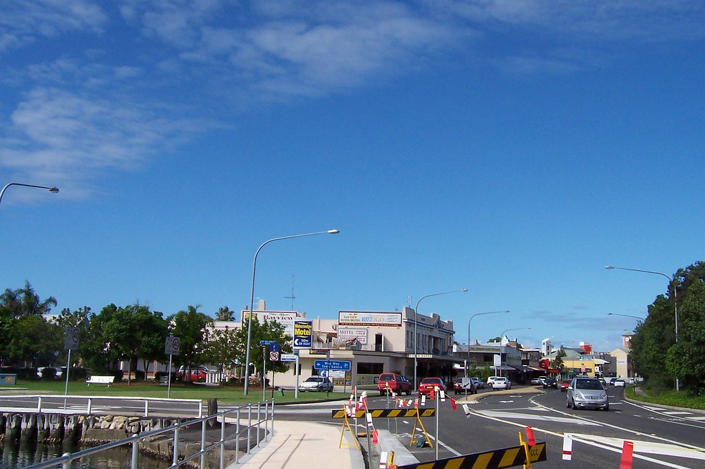
Bustling Downtown Woy Woy from Brisbane Water Drive Woy Woy
(Embiggen)

Bustling Downtown Woy Woy from Brisbane Water Drive Woy Woy. Snapped this morning in a brief bit of sunshine. The left hand dge of this photo joins up with the right hand edge of the one above. I'd bung them together but then they'd be too small for any detail.

Left to right:
Small park whose name I keep not finding out. The Bay to Bay Fun Run left from here last year.
Bay View Hotel. Same pub as was being menaced by a large cloud a few weeks again.
Wee 1950s arcade containing smallest hairdressing shop I've ever seen. Behind it, for the eagle-eyed, is the back of the facade of Noonan's.
The red veranda is a real estate (one of the many) one door along from Noonan's. You can't actually see the traffic lights but they're at the red veranda. At the lights the road stops being Brisbane Water Drive and starts being Railway Street.
The yellow building is on Railway Street as is the dark veranda you can see between it and the red veranda.
The two slim towers, background, one grey the other orange, are the 4-storey carpark outside Deepwater Plaza.
The clock tower is the Clocktower Building on Railway Street.


WTF is that thing?

Blackwall Road Woy Woy cnr Victoria Road

6 months back they knocked down an elderly fibro cottage, a circa 1940s Presbytery and a peculiar 1950s building at the Blackwall Road-Victoria Road roundabout in Woy Woy, opposite 1914 St John's.

This is what they're bunging up in their place. It's either a new St John's (the old one is a bit cracked) or a landing pad for lopsided helicopters.