Showing posts with label Saratoga. Show all posts

Saturday, September 13, 2008

Ye olde Post Offices

You should be hearing this post in a faint scratchy voice frequently interrupted by a hacking cough and intemperate language. I am definitely Not Well. And definitely Utterly Fed Up. It's one of these new-fangled wogs that's resistant to anti-biotics and takes a while to shift.


Steyne Road Saratoga

This wee old cottage is the former Saratoga Post Office, on Steyne Road, facing Point Clare across Brisbane Water. It has been posted on a stamp-fanciers' board (ta for the acknowledgement & link, Skippy), along with a lovely old photo of when it was the P.O..

Also check out the old Matcham PO further down the board. It is barely bigger than a backyard dunny.


Old Kincumber Post Office

One of the old Kincumber Post Offices, on the corner of Avoca Drive & Davies Street, opposite Frost Reserve.

Run by William George Humphrey from 1945 to the 1990s. Before that the P.O. was down the road a bit at Manasseh Frost's place (below).

Old Kincumber Post Office

You can still see the old "Kincumber Post Office" sign up under the upholsterer's sign.

Old PO Boxes

The old PO Boxes are still there, albeit closed up. I wonder if the upholsterer uses the backs of them as a cupboard?


Manasseh Frost's Store & Post Office Avoca Drive Kincumber

The other of Kincumber's old Post Offices, and Manasseh Frost's Store (1901), just a couple of blocks down the hill from the other old P.O..

The sign on the right of the building reads "M Frost Kincumber Cash Store".


Stone stumps

Sheets of tin over the top of each stone stump to stop the ants eating the wood of the building.

More on Frost's Post Office


Woy Woy's own old P.O.'s are long gone but you can see their photos up in the current P.O. (opposite the library, just near the station) and here, second from the right.

There's the old "PMG" (Post master General) lettering on a Woy Woy manhole cover on Brisbane Water Drive between the Bay View pub and the footbridge.

You can have fish and chips in an old Post Office (albeit a seventies one) by getting the ferry to Empire Bay and walking to the orange and brown building you can see from the wharf.

Recommended fiction for stamp-fanciers is Terry Pratchett's Going Postal. It is amusing even to non-philatelists and has a hero called Moist von Lipwig.


Snippets

Old news but worth having: Australian researcher saves the planet

"An Australian researcher has won an international prize for her plan to wrap a giant asteroid with reflective sheeting to stop it colliding with the earth and destroying all life.

Such an impact would have the force of 110,000 Hiroshima atomic bombs if the asteroid, which actually exists, hits the planet in 2036, said Mary D'Souza, a PhD student with the University of Queensland's School of Engineering."

Click for the spectacular digital mock-up picture, stay for the scary asteroid stats.

Woy Woy girl competes in her fifth consecutive Paralympic Games - Australian basketball capt. Liesl Tesch in Beijing


Right then. I'm logging out before I crash on the keyboard. Thank you very kindly for all the hugs and haiku and tips. It makes a person get well a bit faster than by mere meds alone.

Tuesday, August 05, 2008

Broadwater Drive Part II

Broadwater Drive (Part I) from Saturday.

(Saratoga walkies #12, not sure if it's 10 or 12 but bugger it)

Ferry routes of Brisbane Water

Kincumber Broadwater is just above the cross at the right hand middle of the map. Broadwater Drive is pretty much under where the "Ki" and "Br" overlap the shoreline.


Weston Street Saratoga

Broadwater Drive runs off Davistown Road in Saratoga. Weston Street is a short steep street running West off Broadwater Drive up near the Yattalunga boundary. There's only a couple of houses on it, it's that steep. This one is up the top. I think there's a house there. There's certainly a drive-way to it (below) but you can't see a bloody thing from the road.


Weston Street Saratoga

Tree-lined drive-way at the top of Weston Street. Opposite it is bush. It was a hot wet day, a muggy Autumn morning, when I hoicked my carcass up Weston Street. As I sweated my way up the street then slithered back down the loose stones on the road, I could hear nothing but the distant drone of a speedboat and the clear single note of a bell-bird's call.


Under the mangroves, Broadwater Drive Saratoga

Have put this photo in again because I like it. It's down the south end of the long narrow park that runs along the foreshore behind Broadwater Drive. The houses let onto the park and no doubt the residents make good use of it.

Notice the old tyres for stabilising the bank and the ubitiqious rock oysters clinging to the bricks in the left of the picture.

There was a faint whiff of sun-soaked seaweed and the quiet lap and slap of a slowly rising tide. It was a wee bit cool under the mangroves that morning but in summer they are a glorious refuge from the sun for man and duck.


Alphabet soup

Blasted pictures are being squashed by the sidebar again. Yonks back Fuckkit send me a thing for how to make a blog wider but gmail has chucked the bastard out. Will have to hunt the code down when I've got a sec. Fuckkit is in Fiji or summat now.


The flicks

Went to the flicks today. Cheap Tuesday at Ettalong. Saw The Bank Job. It was funny, smart and violent. Just the kind of flick I like. Based on a true story about the 1971 Baker Street robbery in which a bank vault of safety deposit boxes got tunnelled into and the crims found naughty pictures of a member of the royal family, which is Princess Margaret in a three-way in the film.

There was stand-over men, an archeaological site, naked people, amusing gaffs on walkie talkies, bent coppers, the aforementioned three-way, spooks (spies), pollies behaving badly, a gruesome torture scene, and the baddest guy gets a good kicking. Good clean fun.


Dredging saga continues

There's a shitload of sandbanks in Brisbane Water, mostly around the Ettalong area, and including one big one at the corner Ettalong and Umina beaches that the Palm Beach ferry has to skirt. (See ferry routes between The Rip and Lion Island above.)

Various sections of local and state government are still squabbling over who's paying for the dredging. They've been at it a couple of years that I can remember, probably longer.

From the Express Advocate:
"The Palm Beach ferry "transfers 400,000 people a year between the coast and Sydney's northern beaches.

When bushfires closed the Pacific Highway, F3 and the train line in 2002 and again on January 22 last year, the service ran 24 hours a day as the coast's only direct transport link to Sydney."

"The channel between the rocks south of Lobster Beach and shifting sandbars on the Ettalong Beach side has been reduced to between 12m and 15m wide depending on the tide.

Mr Lloyd said a 10m wide ferry could not navigate the channel if another boat even a runabout was coming the other way.

"We'd either crash, run them into the rocks or swamp them in our wake," he said." More)

Safety fears could sink ferry service


Footy ferry

The local ferry crowd, the same crowd that run the Saratoga and the wee old Codock II, are doing a ferry run to the footy. Up to Gosford wharf from various stops on the Empire Bay run to the Mariners game at Bluetongue AKA Grahame Park.

Saturday, August 02, 2008

Broadwater Drive

(Saratoga walkies #10? 12? Yeah, about that.)

Very quick post this morning. I'm off in a few minutes.


Kincumber Broadwater from Broadwater Drive Saratoga

All these photos are taken from Broadwater Drive Saratoga overlooking the Kincumber Broadwater.

More about the area on Tuesday.


Under the mangroves, Broadwater Drive Saratoga

Under the cool shady mangroves.


Kincumber Broadwater from Broadwater Drive Saratoga

Stripy water on the Kincumber Broadwater.

Map of the Kincumber Broadwater & Saratoga. Broadwater Drive is not marked but rruns along the edge of Saratoga facing the Kincumber Broadwater.

Saturday, July 12, 2008

A little house by the water

For long-winded and boring reasons, I can't yet upload the photos I took while I was offline. So we'll look at a few of my favourite wee old houses around Woy Woy and Brisbane Water.

Mulhall Street Wagstaffe

#1 (Map reference)
We'll start with this lovely old place overlooking the water from Mulhall Street Wagstaffe. Its owner, Geoff, tells us it was built in 1907 and the bargeboards (those curly white boards on the edge of the roof) are original.

Geoff on the house's history


Foreshore at Leonora Avenue Davistown

#2
On the water at Leonora Avenue Davistown. Just a few steps from the Lintern Street ferry stop and there you are. Bloody nice spot for a house.


Henderson Road Saratoga

#3
A home among the gum trees. Just like the song says. Henderson Road Saratoga, looking across the Lintern Channel to Woy Woy.


Sorrento House Sorrento Road Empire Bay

#4
Sorrento House Sorrento Road Empire Bay. One street back from the water and 30 seconds from the Empire Bay ferry stop. Must be 18 months now since this one was bulldozed.


Albany Street Point Frederick

#5
Albany Street Point Frederick (Longnose), looking down into Caroline Bay and across at Peeks Point.


Croke Cottage at St Joseph's Orphanage Kincumber South

#6
Croke Cottage, in the grounds of the old orphanage at Kincumber South. Out the back door and twenty yards down to the water. The old orphanage ferry stop is about 60 yards away. A very quiet spot at the mouth of the Kincumber Broadwater.


Twin houses Parks Bay

#7
Twin houses at Parks Bay, just across the water (and the railway tracks) from Woy Woy.


Meena Street Woy Woy Bay

#8
Meena Street Woy Woy Bay, circa 1908, just across the water from Woy Woy. Sharp-eyed persons will have noticed this lovely old place in the background of interviews with Belinda "Anger Management Issues" Neal, of Iguana-gate fame.


Ocean View Road Ettalong

#9
Lovely old house on Ocean View Road Ettalong. This is its back view. It looks across Lance Webb Reserve to Wagstaffe and, further, to Barrenjoey Head.


Cedar Crescent Woy Woy

#10
Cedar Crescent Woy Woy, looking over the tops of the houses opposite across the water to St Huberts Island and Davistown. That glassed-in veranda is the perfect spot to settle down on a cold winter morning with the sun coming in and a nice hot cuppa tea and a bacon sarnie.


Match the # numbers on the photos to the map.

(Thepurple dots are the route of the ferry Saratoga, the other dots are the route of the Cockatoo ferry Codock II.)


P.S.

Is it just me or does everyone hear that line "I had an uncle who once played for red star belgrade" in Sexuality as 'I had an uncle who once laid a red star brigade'?

Tuesday, March 04, 2008

Peeks Point

(Gosford walkies #33, East Gosford)

My records say the last time I walked in Gosford was November 2006. Bollocks! More like November 2007.


View from Caroline Street Peeks Point
(Clicking leads to embiggening)

View from Caroline Street. Lovely clear day for photography today. Now that summer's over the rain has gone away.

Left to right: Rocky Point, Green Point/Kincumba Mountain behind it, Killcare in the distance, and Saratoga's Bayview Wharf area on the right.


Samuel Peek's Township at Brisbane Water

The sign reads:

"East Gosford
Samuel Peek's Township
at Brisbane Water

The population of Brisbane Water in 1828 was 99 [white people],
of whom 56 were assigned servants [convicts], with only 11
women living on the estates of 14 large landholders.
There was no urban development, no township
or village, no provision for young couples to buy
an allotment where they could build a cottage and
raise a family while practising an independent trade
There was no road, no bridge, no shop, baker
butcher or general store.

Samuel Peek was a Sydney businessman of many
interests and achievments. The population of the colony
had much increased since 1831 & he saw the need
for a township, and seized the opportunity offered.
He bought a vacant area of 500 acres of land at
Brisbane Waters and commissioned a proficient
surveyor to lay out a proper township with provision
for public amenities: Court House Churches,
Marketplace, and Pound.

The first allotment was offered for sale in Sydney on
13 February 1838.
The Census of 1841 informs us that already 178 people
lived at east Gosford:
95 men, 33 women, 50 children in 21 dwellings.

Sponsored by
EAST GOSFORD PROGRESS ASSOCIATION
ROTARY CLUB of EAST GOSFORD".

Bugger all remains to be seen of the original township. The houses there now are mostly 1940s and '70s with an occasional Federation cottage like this.


View from Caroline Street park Peeks Point
(Clicking leads to embiggening)

View from the park in Caroline Street.

Left to right: Ironbark Point (pair of yachts), Rocky Point, Green Point/Kincumba Mountain behind, Saratoga, and the water tank of Woy Woy Peninsula's Mount Ettalong on the right.

The water views were taken within an hour of each other and at pretty much the same angle from the sun, but check out how different the colour of the water is.


Ironbark Point from Russell Street Peeks Point
(Clicking leads to embiggening)

Looking across the water to Ironbark Point from Russell Street. Another quiet little bay in an estuary full of quiet little bays.


Red-tipped tree leaves
(Clicking leads to embiggening)

Red-tipped leaves on some sort of eucalyptus tree. Don't ask me what sort. I ain't no botanist.

Extra photo, didn't quite make the grade.

Thursday, February 28, 2008

Moody views

(East Gosford walkies #3 or thereabouts, map)

Purple & yellow flowers

The yellow flowers are everywhere around Brisbane Water, on large loose bushes. The purple ones are a climber that hangs over the wire fence along the railway line.

(Took this before the light went to hell. Right now it's gone all dark again, as dark as the third photo. Pissing down raining too. Been at it since all day. it nippy actually. Funny old weather for the last day of Spring. Usually I'd be blogging in me underpants and whinging about the heat.)

Anyways, I went into Gosford then tramped up and over Henry Parry Drive and into East Gosford. Went to a street there I'd seen from when I found the old quarry. Between it and the quarry is a small valley and across the valley I could see a street. So today I walked it.


View of Rumbalara Reserve from Bay View Avenue East Gosford

Rumbalara Reserve from Bay View Avenue East Gosford. Nice street Bay View. Not too badly infested with the 1970s buildings, bush and water views on one side, water views on t'other side, and bush up the back.


The Entrance Road & mangroves from Bay View Avenue East Gosford

This bay doesn't have a name in my 2006 street directory. Let's just call it Punt Bridge Bay because you can see it from Punt Bridge as you drive along The Entrance Road to Bloody Erina (Erina Fair).

The grassed bit on the lower left hand of the photo is Hylton Moore Park soccer oval. The trees around the bay are mangroves. The houses on the other side of the water are the Sun Valley Road area off Avoca Drive near Ironbark Point. The hills behind them are part of Kincumba Mountain.


View from Bay View Avenue East Gosford 1

The hill in a line with the road is Saratoga. The tree on the right of the photo is obscuring Woy Woy. The low bit to the left of Saratoga is Yattalunga. The hill behind is Killcare Heights (beyond which is the Tasman Sea).

Behind the tree in the left foreground is Green Point and Kincumba Mountain slopes off to the left edge of the picture.

The street was bloody steep. And it was raining. I muttered and grumbled and whinged my way up it. Turned round when I got to the top and had a look at the views. Bloody excellent. No doubt you could see all the way to Barrenjoey Head on a clear day but I rather like the misty views of a rainy day.


TS Hawkesbury & Point Clare from Bay View Avenue East Gosford

I particularly like this one from the other side of the road. TS Hawkesbury & Point Clare seen across The Broadwater, with Kariong and the ridges folding in behind on their way to Mooney Mooney Creek and the Great North Walk.


Fagans Bay from Bay View Avenue East Gosford

The Broadwater, Fagans Bay (right) and the houses along its southern edge. Fagans Bay is separated from The Broadwater by the railway line as it comes into Gosford from Woy Woy.

Up the top of the street it was flat and the houses were back from the road. The rain spattered on my brolly and the wind shook the tall gums. I could see Rumbalara Reserve across the valley and hear a bell bird in a tree somewhere. Despite being quite close to the traffic down on York Street, it was quiet and isolated.


Bay View Avenue East Gosford

Ignore the ferry routes. Look at the red wiggly line up the top. That's Bay View Avenue. It's way up on a ridge and the view from up there goes right down Brisbane Water.

Tuesday, January 22, 2008

King tide

(Davistown walkies)

High tide this morning was bloody high. It's full moon and and the tide had swallowed all the wee beaches round the estuary and submerged half the private jetties and dozens of dingies.

The public jetties are made of sterner stuff but the Dear Old Things and I needed sherpas to get up the steep slope of the gangplank onto the Saratoga. They were off to the Davo for a steak sanger and a shandy and I was off to finish off the last few streets of Davistown.


King tide creek Lillipilli Street Davistown

King tide creek Lillipilli Street Davistown. Edge of the wetland beside the road under water.

Lillipilli is a native plant, "a bush" says the Dear Old Thing downstairs, "excellent for hedges". There's some good close-ups of lillipilli flowers and inhabitants here.

Wetland Lillipilli Street Davistown

Wetland between Lillipilli Street and Murna Road. Looking down through the shallow water I could see the cracked earth of the drought years slowly swelling with moisture and little water critters playing about.

The wetlands are "Swamp Sclerophyll Forest", as I rabbitted on about a while back when I did Cockle Bay Wetland. This swamp is not far from Cockle Bay, a bare 200 metres.


Tidal Waters Davis Avenue Davistown

Tidal Waters villas on a canal, end of Davis Avenue Davistown.

If you'd asked me what I expected to find lurking at the end of an ordinary-looking street in Davistown I would not have said a canal, but a canal there was. It led out past the Davo and into Kincumber Broadwater. The villas each had their own little stone steps leading down to a miniscule landing and a nice ring to tie their dingy up. It looked rather fun.


Murna Road canal off Davis Avenue Davistown

Canal running beside Murna Road Davistown. The canal leading off the Davis Avenue canal and out past the Davo and into Kincumber Broadwater. You can't see it from Murna Road unless you poke your head through the trees beside the road.


Davistown Store c.1920 McCauley Street Davistown

Davistown Store c.1920 McCauley Street Davistown

Not sure what this building does now. Seems to be some sort of office out the back and the front seems uninhabited.

Circa 1920 says my hist list, and it looks it. Nice inter-war bungalow. Right next to the public wharf too so handy for the boating trade in its days as a shop.

Lovely cool east wind again today. Yesterday I sat on the balcony for hours just watching it gusting in the old gum next door. Over at Davistown I sat today on the foreshore and listened to it roar soft and cool through the needle-leaf pines and the water slap and splash against the tied-up boats.


Walkies map January 2008

Updated my walkies progress map at last.

Saratoga and Davistown are at 1 o'clock and 2 o'clock from Woy Woy.

Walkies finished marked in solid orange. Walkies unfinished marked in orange stripes.


Still got a bit to go of Saratoga and Hardys Bay etc. Gosford I've done a bit of but not much. Bradys Gully cemetery was a North Gosford walk.


Walks I have finished since I started

The Peninsula: Woy Woy, Blackwall, Umina, Ettalong, Booker Bay, Pearl Beach & Patonga
Correa, Horsfield, Phegans & Woy Woy Bays
Parks Bay
Koolewong/Murphys Bay
Tascott
Point Clare
Longnose (Point Frederick)
Davistown
Empire Bay
St Huberts Island
Daleys Point
Fishermans Bay
Wagstaffe

Walks I've done bits of since I started

Kincumber
West Gosford (might've finished this but can't be buggered looking it up)
East Gosford & Springfield
Gosford
Hardys Bay
Pretty Beach

(There's a better list somewhere in my archives. If anyone's got the URL for it, pop it in the comments there's a dear, I've spent half an hour looking for the bastard.)

Monday, July 30, 2007

Saratoga views

(Saratoga walkies #9)

Saratoga, Davistown & Yattalunga map
Embiggmification

There yer go. Now you can see what I mean when I say the Saratoga/Davistown peninsula is hammer-shaped. Saratoga is the first stop on the Saratoga and Codock II ferry runs.

(In an hour the Flickr version map & photos will be annotated. Which will save you reading all that stuff and looking for the third tree on the left.)

Gosford is off the map up past the top left corner. Woy Woy is, obviously, the one marked Woy Woy, down there at the bottom.

Rileys Island and Pelican Island and those two little ones are uninhabited. St Huberts is the canal'd one with all the seventies houses on it.

The cross halfway up the right hand edge is the Holy Cross church and St Joseph's orphanage, where the old ferries were operated from.

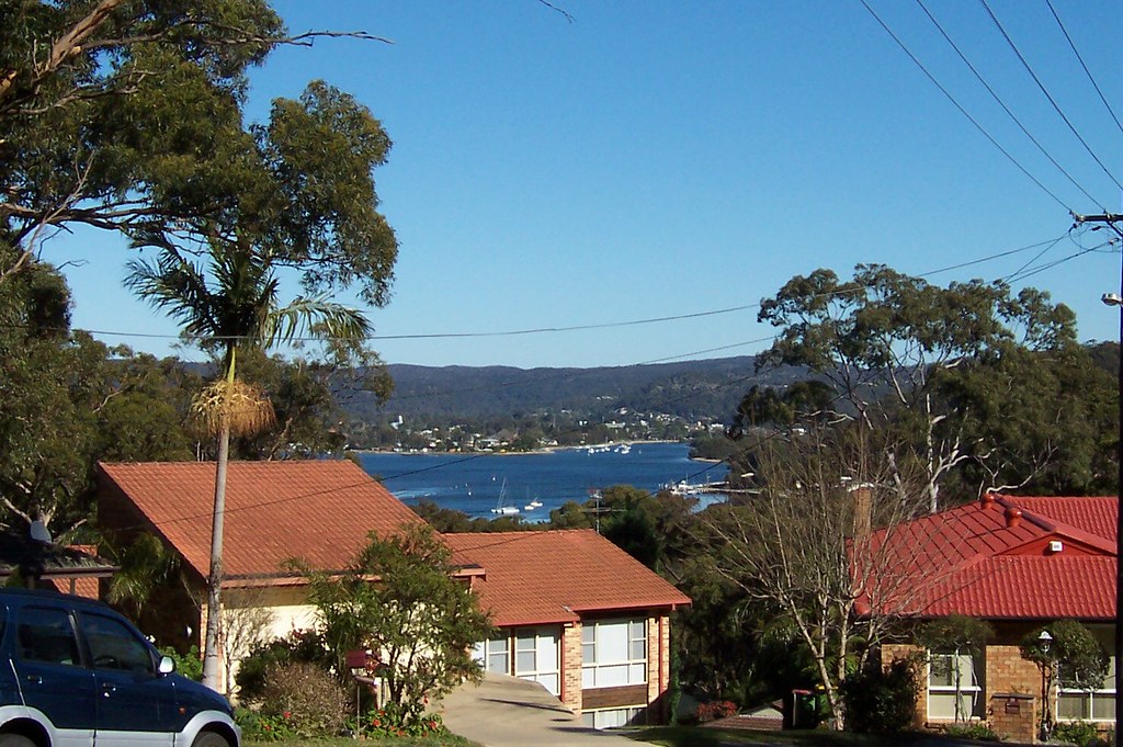
View to Woy Woy from Shaw Street Saratoga
Embiggmification

View to Woy Woy from Shaw Street.

We're looking straight across to the Bowls at Woy Woy, at the end of North Burge Road.

To the left of the Bowls is the foreshore park running parallel to North Burge Road.

To the right of the Bowls is the foreshore park running parallel to Brick Wharf Road and into Bustling Downtown Woy Woy between the pubs.

The Woy Woy Channel is running back from the furtherest cluster of boats and that's the tip of Pelican Island to the right of the boats and the Veteran Hall Wharf on Henderson Street below Pelican Island.

View to St Huberts from Shaw Street Saratoga
Embiggmification

View to St Huberts from Shaw Street. Took a while to work out what I was looking at with this one.

First is that tight grove of trees on the grassy area (between foreground trees). That is Illoura Reserve, the part at the end of Malinya Road. Passengers on the Saratoga ferry will see it as the ferry turns the corner from Lintern Channel into Cockle Channel and heads for Central Wharf.

Empire bay is beyond that and to the left of the foreground trees, and the house there is on Myler Avenue or Yaringa Parade. The hill above that house is also Empire Bay.

To the right of the left foreground tree is the ramp down to St Huberts Island.

St Huberts is hard to distinguish from the houses of Daleys Point behind it so we won't give ourselves eyestrain trying.

The hill behind St Huberts & Daleys Point is Killcare and beyond Killcare is the Tasman Sea.

On the right edge of the photo is Blackwall Mountain. Probably. It's too close to be Mt Ettalong and nothing else in that direction is high.

To the left of that, just visible in the far distance, is Barrenjoey Head and in front of that is the sandstone cliff that forms the eastern end of Lion Island and the chest of the lion.

View to Gosford from Kapala Avenue Saratoga
Embiggmification

View to Gosford from Kapala Avenue.

That's Longnose there, Point Frederick, with the old cemetery on the end there in Pioneer Park.

Behind it is the hills of West Gosford and beyond them we're looking at the Peats Ridge/Mangrove Mountain area.

Friday, July 27, 2007

Saratoga slog

(Saratoga walkies #8)

The great lethargy has not lifted but I did manage to overcome it for a morning and drag myself round the streets of Saratoga.

It was a blue sky day. The birds were hopping and fluttering about picking up worms and rubbing their beaks together in a flirtatious manner. The sun was warm on my back and the flowers were bright. The hills were long and steep and I'd left my map at home but it was good to be out on the road again.

Henderson Road Saratoga

This shag was not hopping or fluttering. It was having a good long soak-up of sunshine. The water birds were not very active, mostly just sitting on rocks and poles sunning themselves with their eyes closed.

Henderson Road Saratoga

Mother Duck is the name half obscured on that 3rd boat back from the front.

I like this rack of boats. Technically it'll be called a mooring or summat but I like the phrase a rack of boats. This rack is on Henderson Road and that's Rileys Island, one of the uninhabited ones, in the background.

High Street Saratoga

No idea what this climber is called. It had no perfume more's the pity but it was a pleasant site draped over its grey fence.

Shaw Street Saratoga

Sandwich houses I call these ones. Don't know if there's a technical name for them, but with their flat wide shape they look giant sandwiches to me. I've seen perhaps a dozen of the 1950s ones on my travels around the Peninsula and Brisbane Water and a few in the 1970s. This one was on Shaw Street.

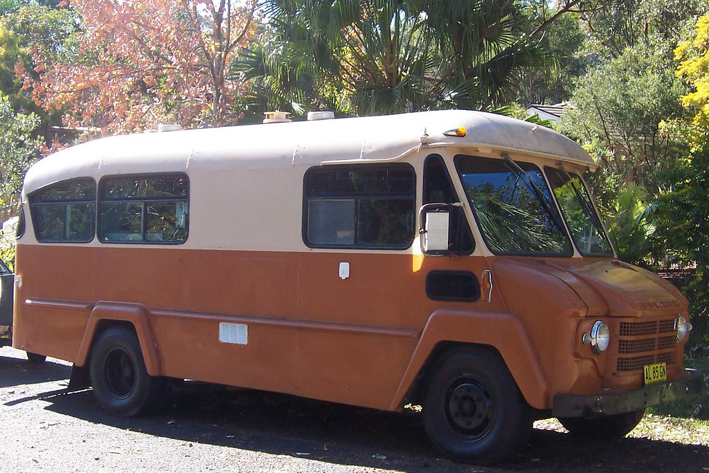
Commer Morrison Street Saratoga
Embiggen

Commer bus fitted out as a camper van, Morrison Street. Never seen a Commer bus before. Google tells me they were made in the UK between 1905 and 1979 by a UK manufacturer of commercial vehicles. Commer got bought out by the delightfully named Rootes company and they ended up in the hands of Dodge.

Google spat out a stack of images labelled Commer, including a rather eccentric bus looking like a double-decker glasshouse on wheels, but no image matching this model.

An identical wheel arch is visible on a Commer/Dodge here, bottom centre image and Commer later made the postal vans for the UK Royal Mail that look a lot like Postman Pat's van.

Best guess is this is a late 1950s model campervan. Fuck knows why I didn't look at the model when I saw the bloody van.


Comments & email

Pommy commenter Patty has not yet been flooded out. Good to hear.

Trainspotty & Michael suggest flu and lack of sun as a possible solution to the lethargy mystery.

They could be right (and Trainspotty's duckshit avoidance advice is noted) but Ron's answer is best: excessive gravity. Had a look at my Gravitex 3000 and the bloody gauge is stuck on 3G's! I'll have to get a little man in to fix it.

(BTW Ron, did you get my comment on bunging videos in posts?)