Jesus H. Christ.
Bloody got sick again. Another bloody round of the bloody flu. No fair.
Been laying on the sofa for days with a rug over me, a jar of Vicks to sniff and 4 seasons of Supernatural to keep me company.
The good news is, no-one's started world war 3 (unless I slept through that news bulletin) and I seem to be on the mend at last.
Got some pictures somewhere to blog but my enfeebled brain can't find them. Next week.
Wednesday, September 22, 2010
Saturday, September 11, 2010
Fuckwittery
Muslims are welcome on this site. Koran-burning fuckwits are not. Burning holy books, whoever they belong to, is not on.
Just wanna make that perfectly clear. Whatever this Koran-burner does, no matter what the reaction in the Muslim world, that welcome still stands.
I am not a fan of behaviour designed to provoke another war, more dead soldiers in the current war, more dead civilians in war-zones, religious riots or unpleasantness or whatever in Sydney's streets or any streets anywhere on the planet.
We are all the same. Outbreaks of fuckwittery, whatever their motivation, all over the globe and through all periods of history, are proof of that.
Our differences are pretty minor and are there to be enjoyed. If you really need to make other people miserable to "improve" your life, it's time to bite the bullet and look at why your life is so shit.
This yes-no-yes-no Koran-burning fuckwit needs to be arrested and assessed by a psychiatrist. If he's got to make a fuss to enjoy himself, why can't he just join an amateur theatre like normal people?
Wednesday, September 08, 2010
Fucking flu
(Live from the sofa)
Jesus H. Christ.
No sooner had I left off writhing about in pain and an unseemly fashion than I was struck down by the Dreaded Lurgy. A proper Lurgy not the ManLurgy! Thought I'd escaped the lurgy this winter then some swine sneezed at me in the pub.
Several packets of antibiotics later and I'm out of bed again, my face has stopped throbbing and I'm no longer fondly contemplating an early death.
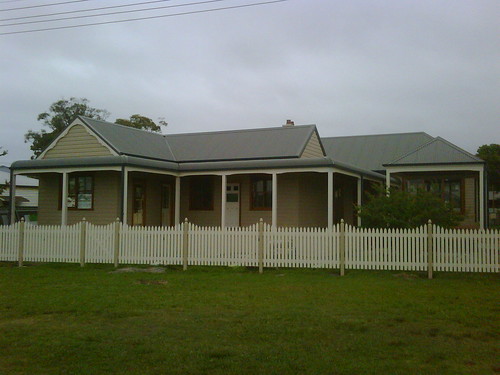
The photo above is not my sofa. It's Sorrento House at Empire Bay, remodelled and complete. Thank yer, Craig.
Got a stack of photos on the other computer of it in the building process, with its cladding off and its chimney stack showing. The other computer seems very far away. You'll have to hold yer breath.
Christchurch
Apart from mass attacks of gastro and nippy nights camped on their front lawns and stuff, the Kiwis of Christchurch got off pretty lightly compared to that Haiti quake which was apparently the same size. But they did have a nasty big after-shock. And I was gonna say something else about their quake but my brain has conked out.
"Devastatingly vicious" aftershock rocks Christchurch (SMH, includes video links)
NZ Herald: Quake articles, photos & links
Shaking Maps (NZ's quake watch site)
The quake on Wiki (includes NZ's quake history)
NZ is roughly the size of Japan or the UK (Britain) including all of Ireland or California plus half of Oregon. Its entire population is about 4,400,000 (Sydney's population is 4,500,000). Christchurch is NZ's seond largest city and has about 380,000 people.
Where the hell is New Zealand anyways? (mappage)
NZ from space (pretty)
Major towns & cities of NZ (Christchurch marked)
Vic floods
Some of those poor bastards who copped it in the Black Saturday bushfires are now under flood. Fucking hell.
New threat after floods: disease (includes video)
Bloody Blogger
The no-click weirdness continues on posts. It seems to lick in after a day or two so either be very quick making comments or make them on older posts like this one. I get a comments alert thingo.
Okay, that's it from me for now. My head is throbbing again and I'm desperate for my dinner.
Jesus H. Christ.
No sooner had I left off writhing about in pain and an unseemly fashion than I was struck down by the Dreaded Lurgy. A proper Lurgy not the ManLurgy! Thought I'd escaped the lurgy this winter then some swine sneezed at me in the pub.
Several packets of antibiotics later and I'm out of bed again, my face has stopped throbbing and I'm no longer fondly contemplating an early death.
The photo above is not my sofa. It's Sorrento House at Empire Bay, remodelled and complete. Thank yer, Craig.
Got a stack of photos on the other computer of it in the building process, with its cladding off and its chimney stack showing. The other computer seems very far away. You'll have to hold yer breath.
Christchurch
Apart from mass attacks of gastro and nippy nights camped on their front lawns and stuff, the Kiwis of Christchurch got off pretty lightly compared to that Haiti quake which was apparently the same size. But they did have a nasty big after-shock. And I was gonna say something else about their quake but my brain has conked out.
"Devastatingly vicious" aftershock rocks Christchurch (SMH, includes video links)
NZ Herald: Quake articles, photos & links
Shaking Maps (NZ's quake watch site)
The quake on Wiki (includes NZ's quake history)
NZ is roughly the size of Japan or the UK (Britain) including all of Ireland or California plus half of Oregon. Its entire population is about 4,400,000 (Sydney's population is 4,500,000). Christchurch is NZ's seond largest city and has about 380,000 people.
Where the hell is New Zealand anyways? (mappage)
NZ from space (pretty)
Major towns & cities of NZ (Christchurch marked)
Vic floods
Some of those poor bastards who copped it in the Black Saturday bushfires are now under flood. Fucking hell.
New threat after floods: disease (includes video)
Bloody Blogger
The no-click weirdness continues on posts. It seems to lick in after a day or two so either be very quick making comments or make them on older posts like this one. I get a comments alert thingo.
Okay, that's it from me for now. My head is throbbing again and I'm desperate for my dinner.
Tuesday, August 17, 2010
Still bloody crook
(Sick note #244)
Boring shit
Still bloody crook. Laying in a sunny window resting after all that writhing in pain last week. This being crook shit is fucking boring.
Weird shit
Everything works when I log in but when I just go to the front page of my blog I can't click on any of the links, not even the comments link. Never happens visiting anyone else's blog. Very weird. Far too weird to figure out right now.
Fun with links
Boganpedia (What bogans are)
Uncyclopedia "WARNING! This article is designed to offend.
If you are not offended by it, please edit it so that you will be in the future."
Sunday, August 08, 2010
Sick Note #243
Argh!
Lovely winter's day in Woy Woy. Sun's been out all day. Could be outside running round enjoying myself. Instead, I've been groaning in bed clutching the guts since yesterday. My stupid poo tubes are having another hissy fit. I am not amused.
Gone
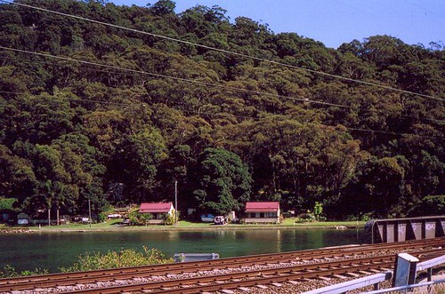
The wee house on the right is gone now. Couple of weeks back I think but I kept forgetting. Pity. Twin houses are fun. But Lefty's still there.
They It is at Parks Bay, just across the water (and the railway tracks) from Woy Woy. Head out from Woy Woy going along Brisbane Water Drive towards Gosford. As soon as you get through the lights and past the pub, take a squiz to yer left and you'll see it as soon as you get to the railway bridge. Which is always sooner than you think it will be.
Local linkage
Winter floraland and the Bluetongue footy fixtures in this month's ferry newsletter.
Ta, Michael, for the heads up about the comments thingo disappearing from the last post. All my sidebar stuff is down the bottom of the page too. Fuck knows what that's about. I think that happened once before then came good. Anyways, I'm way too tired to work it out today. Comments are still working on this post.
I'm going back to bed with a hot-water bottle and the remote.
Lovely winter's day in Woy Woy. Sun's been out all day. Could be outside running round enjoying myself. Instead, I've been groaning in bed clutching the guts since yesterday. My stupid poo tubes are having another hissy fit. I am not amused.
Gone
The wee house on the right is gone now. Couple of weeks back I think but I kept forgetting. Pity. Twin houses are fun. But Lefty's still there.
Local linkage
Winter floraland and the Bluetongue footy fixtures in this month's ferry newsletter.
Ta, Michael, for the heads up about the comments thingo disappearing from the last post. All my sidebar stuff is down the bottom of the page too. Fuck knows what that's about. I think that happened once before then came good. Anyways, I'm way too tired to work it out today. Comments are still working on this post.
I'm going back to bed with a hot-water bottle and the remote.
Sunday, August 01, 2010
Winter in the Paperbark Forest
(Random walkies in Woy Woy)
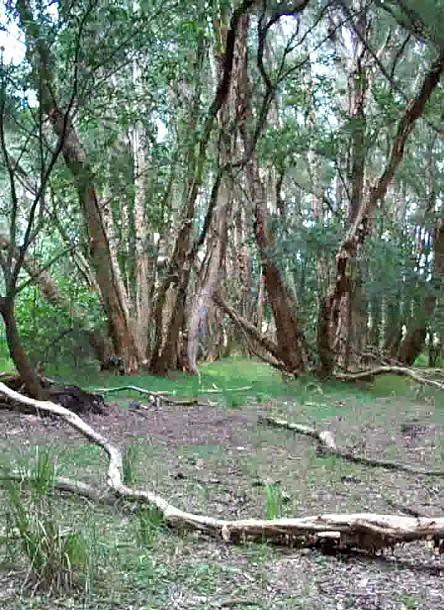
(The camera battery carked it, hence the low res mobile phone snaps.)
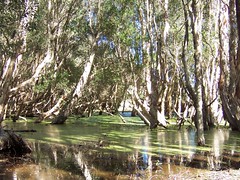
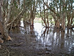
The Paperbark Forest is a wee sliver of bushland sandwiched between a suburban street and the golf course. It's official name is the Everglades Lagoon Wetland. I've been there before. It's one of my favourite bits of Woy Woy.

Wandered up to the forest mid-morning during the week.
There's been a decent bit of rain in the last week or so and the wetland's lagoons are fairly full. The ground is covered in leaf litter right to the water's edge and you can't tell where the mud starts and ends. Put a foot wrong and you'll end up on your arse. You gotta tread slowly from stick to fallen stick.
Had a bit of a wander about then picked a firm bit of ground to stand on, in a tiny clearing back from the water. Just stood there and looked and soaked up the leafy quiet of the place.
Small patches of light outlining the shadows on the ground of the big trunks, there was the plucking almost-cluck of a tree bird at the very edge of the lagoon, the high almost-honk reply from a dozen trees away. Over and over. They should just get together already and do brunch.
Mmm ... brunch ... Dug quietly in my pocket for a bar of chocolate, leant on a spider-free trunk and ate and listened.
The wetland backs onto the golf course and there was the faint sound of a golfball being sworn at. Eventually, the bloke managed to hit it and went off after it and the golf course disappeared from the aural landscape.
A chocolate brown butterfly with white-edged wings flittered about nearby and starlings or something twittered in the trees like twinks at cafe.
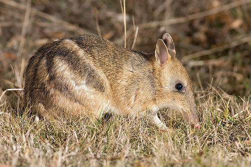
After I'd been still for a while, there was a faint rustling in the bracken under a cluster of trees. Some sort of wee beastie perhaps. Up near the edge of the forest, where it's sandy, there were a dozen small holes dug by small paws. Don't think lizards really hang out in wetlands that much. Could be wrong though. But there's definitely bandicoots on the peninsula and I know they like it sandy.
The breeze picked up again and two tall paperbarks moaned as they rubbed together as slow as Sunday sex. Above that was the soft silvery sound of the breeze shivering through the tops of the trees.
A whole stand of tall straight paperbarks had all grown leaning slightly in one direction. The longer I stared at them, I more felt like I was standing crooked. Started to get vertigo and had to look away.
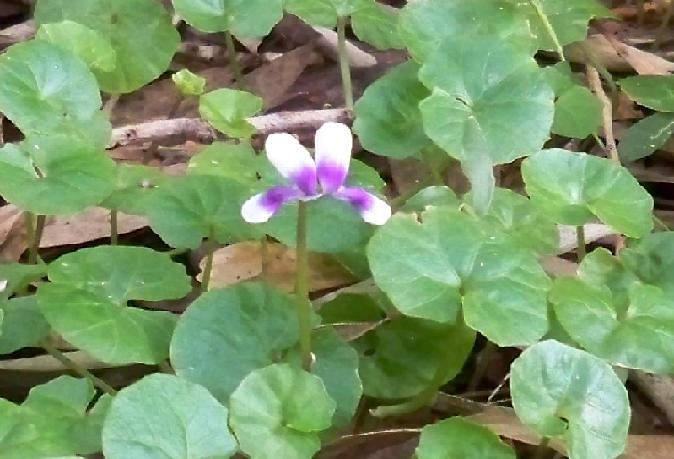
In the drier ground, back from the lagoons, native violets spread out in wide patches. Just a few flowers so far, in the sunny spots, more at the edges of the forest where there was more light.
Long pale branches radiate out across the ground from the trees they've fallen off. Their shapes are flowing and take your eye across the wee clearings to where there's a lone baby cabbage tree palm or gun tree sapling.
A lone kooka gave that faint drumming ound in its throat they do before they laugh. Stood there patiently but it was only warming-up not actually laughing. It sounded like a teenager and I've heard them do that a lot. Maybe they can't laugh until they're adults.
In the spreading trunk of a big old tree, some kids had built a platform for a cubby-house. In the raft of branches laid overhead there were some sheets of newspaper and more sheets all around the tree like they’d been blown out or rained out. Guys, your cubby is in the middle a bloody paperbark forest. You sure there’s nothing better to make the roof out of?*
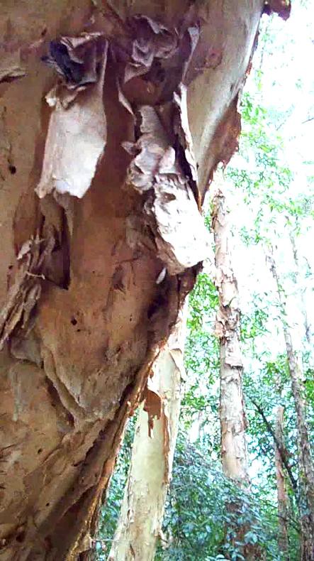
There was a cabbage tree palm every hundred yards or so. Along the edge of the forest, where it borders the lane, there was a thin line of casuarina trees and a gum every now and then. Other than that, the paperbark forest is all paperbarks.
Summer on the left, winter on the right
Paperbark Forest in summer
Bonus photo
Traditional Aboriginal uses of paperbark
Stuff
My favourite shop name on the peninsula? Acropolis Yeeros Chinese Takeaway. Menu includes, kebabs (kabobs to Americans), rainbow steak, chow mein and steak sangers.
Illustrated Ducktionary addition, courtesy of Ron in Fort Bragg
World wide walkies
Fabulous wilderness photos from Kansas
Local linkage
Some fresh this week, some a wee bit late.
Woy Woy at Wordpress
Fabulous fish and crab photos from a kayaker
Comment from old Woy Woy cinema worker on Stevo's model of same
Last chance to see, includes GPS & directions to the Woy Woy hieroglyphs
ACDC concert that never was
A year to the day (Roy Sainty finally found and buried, my sympathies to his family and best wishes to all those still missing a child)
Slightly eerie dusk photo of the beach
Fabulous photos from Empire Bay
(The camera battery carked it, hence the low res mobile phone snaps.)
The Paperbark Forest is a wee sliver of bushland sandwiched between a suburban street and the golf course. It's official name is the Everglades Lagoon Wetland. I've been there before. It's one of my favourite bits of Woy Woy.
Wandered up to the forest mid-morning during the week.
There's been a decent bit of rain in the last week or so and the wetland's lagoons are fairly full. The ground is covered in leaf litter right to the water's edge and you can't tell where the mud starts and ends. Put a foot wrong and you'll end up on your arse. You gotta tread slowly from stick to fallen stick.
Had a bit of a wander about then picked a firm bit of ground to stand on, in a tiny clearing back from the water. Just stood there and looked and soaked up the leafy quiet of the place.
Small patches of light outlining the shadows on the ground of the big trunks, there was the plucking almost-cluck of a tree bird at the very edge of the lagoon, the high almost-honk reply from a dozen trees away. Over and over. They should just get together already and do brunch.
Mmm ... brunch ... Dug quietly in my pocket for a bar of chocolate, leant on a spider-free trunk and ate and listened.
The wetland backs onto the golf course and there was the faint sound of a golfball being sworn at. Eventually, the bloke managed to hit it and went off after it and the golf course disappeared from the aural landscape.
A chocolate brown butterfly with white-edged wings flittered about nearby and starlings or something twittered in the trees like twinks at cafe.
After I'd been still for a while, there was a faint rustling in the bracken under a cluster of trees. Some sort of wee beastie perhaps. Up near the edge of the forest, where it's sandy, there were a dozen small holes dug by small paws. Don't think lizards really hang out in wetlands that much. Could be wrong though. But there's definitely bandicoots on the peninsula and I know they like it sandy.
The breeze picked up again and two tall paperbarks moaned as they rubbed together as slow as Sunday sex. Above that was the soft silvery sound of the breeze shivering through the tops of the trees.
A whole stand of tall straight paperbarks had all grown leaning slightly in one direction. The longer I stared at them, I more felt like I was standing crooked. Started to get vertigo and had to look away.
In the drier ground, back from the lagoons, native violets spread out in wide patches. Just a few flowers so far, in the sunny spots, more at the edges of the forest where there was more light.
Long pale branches radiate out across the ground from the trees they've fallen off. Their shapes are flowing and take your eye across the wee clearings to where there's a lone baby cabbage tree palm or gun tree sapling.
A lone kooka gave that faint drumming ound in its throat they do before they laugh. Stood there patiently but it was only warming-up not actually laughing. It sounded like a teenager and I've heard them do that a lot. Maybe they can't laugh until they're adults.
In the spreading trunk of a big old tree, some kids had built a platform for a cubby-house. In the raft of branches laid overhead there were some sheets of newspaper and more sheets all around the tree like they’d been blown out or rained out. Guys, your cubby is in the middle a bloody paperbark forest. You sure there’s nothing better to make the roof out of?*
There was a cabbage tree palm every hundred yards or so. Along the edge of the forest, where it borders the lane, there was a thin line of casuarina trees and a gum every now and then. Other than that, the paperbark forest is all paperbarks.
Summer on the left, winter on the right
Paperbark Forest in summer
Bonus photo
Traditional Aboriginal uses of paperbark
Stuff
My favourite shop name on the peninsula? Acropolis Yeeros Chinese Takeaway. Menu includes, kebabs (kabobs to Americans), rainbow steak, chow mein and steak sangers.
Illustrated Ducktionary addition, courtesy of Ron in Fort Bragg
World wide walkies
Fabulous wilderness photos from Kansas
Local linkage
Some fresh this week, some a wee bit late.
Woy Woy at Wordpress
Fabulous fish and crab photos from a kayaker
Comment from old Woy Woy cinema worker on Stevo's model of same
Last chance to see, includes GPS & directions to the Woy Woy hieroglyphs
ACDC concert that never was
A year to the day (Roy Sainty finally found and buried, my sympathies to his family and best wishes to all those still missing a child)
Slightly eerie dusk photo of the beach
Fabulous photos from Empire Bay
Saturday, July 24, 2010
Tribute to Vaughn Bode
(Random Woy Woy walkies)

This is Cheech Wizard. He was the best-known charater of Vaughn Bode. He's on a Bode tribute wall in a lane off Alma Avenue in Woy Woy.
(Locals, Alma Ave is the wee street of small factories and stuff off Trafalgar Ave next to the fire station at the shops.)
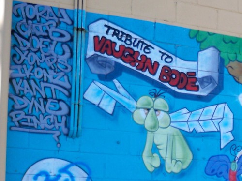
Bode was an American artist who did underground comics, graphic design and graffiti. He died in 1975 at 33. His most well-known character was Cheech Wizard.

Part of the Tribute to Vaughn Bode wall.
The green creature on the left might be Razzberry, the offsider of Cheech Wizard.
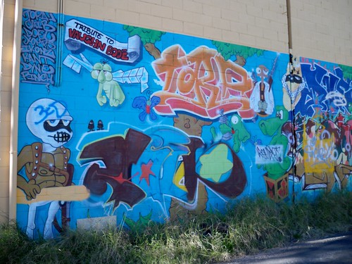
Left end of the mural. Rest of the mural.


My favourite.
Bonus photos
Other murals & (good) graffitti around Woy Woy
Gallery at Bode's homepage (on his son's site)
Bode on Wiki
Cheech Wizard & Razzberry
Other tributes to Bode
Local Linkage
The local ferries crowd has their new newsletter out with the footy ferry and timetables and stuff. Go here.
Nice bit of info about Rileys Island from a bloke whose family was one of its many owners. Ta, mate. (Scroll down to Duncan's comment.)
Righto, that's yer lot for the week. My ride is here.

This is Cheech Wizard. He was the best-known charater of Vaughn Bode. He's on a Bode tribute wall in a lane off Alma Avenue in Woy Woy.
(Locals, Alma Ave is the wee street of small factories and stuff off Trafalgar Ave next to the fire station at the shops.)
Bode was an American artist who did underground comics, graphic design and graffiti. He died in 1975 at 33. His most well-known character was Cheech Wizard.
Part of the Tribute to Vaughn Bode wall.
The green creature on the left might be Razzberry, the offsider of Cheech Wizard.
Left end of the mural. Rest of the mural.
My favourite.
Bonus photos
Other murals & (good) graffitti around Woy Woy
Gallery at Bode's homepage (on his son's site)
Bode on Wiki
Cheech Wizard & Razzberry
Other tributes to Bode
Local Linkage
The local ferries crowd has their new newsletter out with the footy ferry and timetables and stuff. Go here.
Nice bit of info about Rileys Island from a bloke whose family was one of its many owners. Ta, mate. (Scroll down to Duncan's comment.)
Righto, that's yer lot for the week. My ride is here.
Subscribe to:
Posts (Atom)