Thursday, November 29, 2007

Purple penis plant

Fucking horrible day for walkies today. Plenty of sun but flat light and the weather's as muggy as buggery. I had a bit of a wander then sought refuge in the cool of the pub.

Ocean Beach SLSC Trafalgar Avenue Umina

Ocean Beach SLSC Trafalgar Avenue Umina

Finished at last. The outside anyways. The inside looks semi-finished.

T'other one, Umina Beach SLSC down the road a bit, is still being landscaped and having tiles done downstairs.


Dellwyn Elizabeth Mardell Ocean Beach SLSC Umina

Second memorial seat at Ocean Beach SLSC. The other one is dedicated to the memory of Bob da Silva.

Dunnies (left) and playground of the SLSC in the background.

This one says:

"In loving memory of
Dellwyn Elizabeth Mardell
1943 - 2001".


Box Head from Ocean Beach SLSC

Box Head from Ocean Beach SLSC

Box Head was on the telly the other night, on that surf rescue programme. It was filmed a while back and the bit at Box Head was an overturned dingy or summat.

Nice shots of the area from the rescue chopper and, after the campers cleared their tents off the camping ground, the chopper put down and picked up the peeps from the boat.


Barrenjoey Head & Lion Island from Ocean Beach SLSC

Barrenjoey Head & Lion Island from Ocean Beach SLSC

Storm clouds building up out to sea and a raft of small cumulus floating up from Sydney.


Purple penis bush

Purple penis bush. Large firm pannicles with a faint perfume reminiscent of soap.


R.I.P.

Bernie Banton's dead. The mesothelioma got him in the end. He'd had asbestosis and asbestos-related pleural disease for yonks, hence the oxygen tube he wore.

Asbestos is a fibrous mineral. You might know it as the brown and yellow-striped gem stone tiger's eye. The industrial grade is a dull grey. It was used in World War 2 as fire insulation in warships, heaps of houses have been built from sheets of it (in NSW it's called fibro).

It's deadly stuff. The fibres get in your lungs and cells built up round them and pretty soon there's a whacking great lump in your chest using up more and more of the space you need to breathe. It can take years to show you and there's a group of diseases you can get from it, mesothelioma being one of them and the one that can take twenty years to develop.

You can get asbestos diseases from mining it, from manufacturing it like Banton did when he worked for Hardies, from installing it and from uninstalling it or just from being in the same room as the fibres. Men who worked for Hardies died of it and are still dying of it, wives who washed their work clothes have died from it, builders have died from it, home renovators have died from it. Stay away from the shit.

Hardies fucked around with their workers' lives then tried to wriggle out of the consequences. Banton and the rest of the crew that fought Hardies worked bloody hard to get them to cough up workers' comp. Tell you what, I wouldn't be able to sit across the table from a guy who had to cart a tank of oxygen round to live and say he couldn't have any compo. Takes a real lack of guts to do that.


Onya, Bern. Even those who didn't know you will miss you.


ABC article with picutre

Tuesday, November 27, 2007

Old villages

Old villages of the Woy Woy Peninsula

The line of red dots in the centre is not an old village but the WWII emergency airstrip. It was gravel and its remains are occasionally dug up in someone's backyard.

The other isolated and grouped red dots are the old villages of the Woy Woy Peninsula:

Woy Woy (uppermost group)
Umina/West Street (lowest group)
Booker Bay (3 dots on right)
Pearl Beach (2 dots at bottom)


Woy Woy village:

Railway Street, Woy Woy

Railway Street from the railway station

Masonic Hall Railway Street Woy Woy

Masonic Hall Railway Street from the railway station

CWA Woy Woy

CWA Anderson Park, opposite the (current) ferry wharf. CWA stands for Country Womens' Association. The equivalent of the W.I. in the UK, not sure what it's American equivalent is.

Woy Woy Hotel

Old Woy Woy Hotel, the one reputed to be built from bricks nicked from the construction of the railway tunnel.

Woy Woy Library

Woy Woy Library, corner of Oval Avenue. Used to be the old Council Chambers in the 1930s but now the Peninsula's part of Gosford City Council and is administered from Mann Street Gosford.

Woy Woy Memorial Park

Soldiers' Park, now known as Woy Woy War Memorial Park. On the water right next to the fish and chip shop.

Woy Woy Oval in Oval Avenue Woy Woy

Woy Woy Football Oval in Oval Avenue, next to the Library.

Woy Woy Public Wharf

Woy Woy Wharf. Central part of the village then and now. Within 100 yards of the railway station, the shops and both pubs.

More photos of Woy Woy village at Bustling Downtown Woy Woy


Umina village (West Street):

Weird Green Thing

West Street in 2005. West Street is not substantially changed in the last 2 years.
(Ignore the red circle, it marks a gas thingy up on the ridge.)

217-225 West Street Umina

Shop down the quiet end of the shops, past the pub.

Ocean Beach Hotel Umina

The pub, on the corner of Trafalgar Avenue. I have no front view of this pub. A glaring omission possibly caused by propping up the bar.

Shell petrol station West Street Umina

This servo (petrol station) stands where a cinema did in the 1950s, at the Ocean Beach Road roundabout at the south end of West Street.

West Street Umina

The West Street anomaly.

Night safe West Street Umina

Night safe on the former bank. Now the bike shop and now painted blue.

Catholic church West Street Umina

The Catholic church. Rumour has it this place is scheduled for demolition. I saw the drawings for the units to go up in their place but I was drunk at the time and may have imagined them.

Purple People Eater West Street Umina

Purple people eater, a recent addition to the old village of Umina.


Ettalong village:

The Excrescence Ettalong

The Excrescence. Where the carpark of this thing is there was the Ettalong Memorial Club, a three-storey lump in pebble-crete from whose open windows could be heard the aerobics instructor exhorting her ladies to lift! and lift! and lift!

Drop your trousers

Drop your pants/ A soul is wasted when there is no aim". Thus quoth the sign at the drycleaners opposite The Excrescence.

That's it for my Ettalong village photos. Hadn't realised it before but I've got bugger all from there. Must remedy!


Booker Bay village:

King's Store & Booker Bay General Store Booker Bay Road Booker Bay

King's Store & Booker Bay General Store Booker Bay Road Booker Bay.

Old Brick Shop opposite King's Store Booker Bay

Old Brick Shop opposite King's Store Booker Bay


This post is about the villages of the Peninsula but it's also revealed some serious gaps in my photo collection. Mostly in Ettalong. So we all learnt summat today. Bless.


P.S.

I don't pass on chain email but this one is amusing.


For those of you who watch what you eat,
here's the final word on nutrition and health.
It's a relief to know the truth
after all those conflicting
nutritional studies.

1. The Japanese eat very little fat and suffer fewer heart attacks than Australians.

2. The Mexicans eat a lot of fat and suffer fewer heart attacks than Australians.

3. The Chinese drink very little red wine and suffer fewer heart attacks than Australians.

4. The Italians drink a lot of red wine and suffer fewer heart attacks than Australians.

5. The Germans drink a lot of beers and eat lots of sausages and fats and suffer fewer heart attacks than Australians.

So eat and drink what you like. Speaking English is apparently what kills you!

Thursday, November 22, 2007

Lightning & ferries

Lovely storm last night. Great flashes of lightning lighting up the whole sky in one go and sweet fragrant rain. I opened up the curtains and watched the show. The lights went out at 8.34. Only ten minutes though and they came back on. Further up the Coast they were blacked out for hours.

Crap light for photos again today. Here's a few from Sydney Harbour.


Alexander & Borrowdale

Harbour ferries. Alexander and Borrowdale and all the Harbour ferries of their size and livery are named after ships of the First Fleet, the ships what brought the first convicts in 1788.

First Fleet ships:
Alexander
Charlotte
Lady Penrhyn
Friendship
Prince of Wales
Scarborough
Sirius
Supply
Fishburn
Borrowdale
Golden Grove

The first six carried convicts. The rest carried supplies and the Marines who became the colony's prison guards and police.


Seven Seas Mariner & the Coathanger Circular Quay Sydney

Seven Seas Mariner that bloody great boat is called. One of them floating hotels. And the Coathanger in the background of course.


Opera House, ferries & tourist boat

Midday traffic at Circular Quay. Harbour ferry, the Opera House and a tourist boat.

The tourists sit in the tourist boat dressed like purple condoms while it hurtles about the harbour like a mad thing and gives them a drowning and a thrill. Leaves from the old Harbour Master's Steps if I remember right.


Sydney Opera House

There yer go. The picture postcard view. A scrum of nuns, Clive James called it.

Tuesday, November 20, 2007

Tank Stream

(Sydney walkies)

Bloody hot day for a walk. Even with the midday breeze off Sydney Harbour. Forgot to blog yesterday but here's a treasure hunt post to be going on with.


Tank Stream Swamp
Biggulate

Elizabeth Street Sydney.

It was a marsh in 1788. That's when the Poms sent the first lot of convicts and soldiers to Port Jackson (Sydney Harbour) and Sydney was started. It was a tear-drop shaped marsh with its bottom in Hyde Park where I'm standing and its tip between Pitt and George Streets near Market Street.

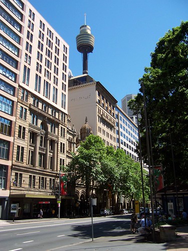
Get off the train at Town Hall, take the Park Street exit and go down Park Street to Hyde Park.


Tank Stream over today's Sydney
Biggulate

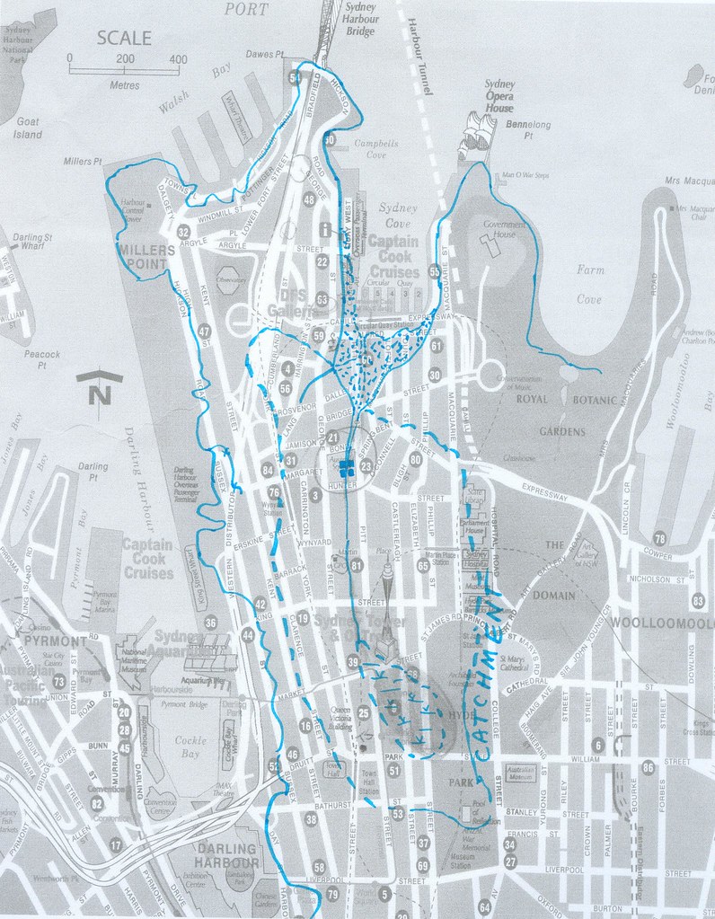
The blue lines are the 1788 shoreline of Sydney Cove (Circular Quay), the catchment area for the Tank Stream (larger area of broken line), the marsh at the head of the Stream (tear-drop shaped), the Tank Stream itself (centre), the tanks cut into the Stream (centre, circled) and the low tide banks at the mouth of the Stream (spotty areas).

From Hyde Park, cross Elizabeth Street, go back along Park Street, turn down Castlereagh Street and walk one block north, towards the Bridge. This takes you across the middle of the old swamp.


Sydney Arcade marker
Biggulate

Marker #1. In the pavement at the entrance to Sydney Arcade, 185-189 Pitt Street.

The textured stripes mark the direction of the Tank Stream in that spot.

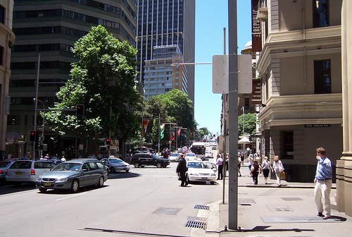
From the corner of Castlereagh Street and Market Street, walk west (towards George Street) along Market Street and turn downhill into Pitt Street. Sydney Arcade is on your left just before King Street.


Sydney Arcade marker close-up

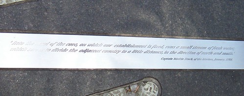
Mark #1 in close-up.

" 'Into the head of the cove, on which our establishment is fixed, runs a small stream of fresh water, which serves to divide the adjacent country to a little distance, in the direction of north and south.'
Captain Watkin Tench, of the Marines, January, 1788."

The stream socially divided the settlement from the word go. The government bits were on the eastern side and the convicts lived on the western side.


Martin Place Cenotaph marker
Biggulate

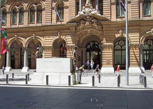
Marker #2. In the pavement next to the ANZAC Memorial AKA the Cenotaph, outside the GPO, Martin Place. You can see the marker in the right foreground of the photo. It looks like two ticks (checks).

From Sydney Arcade, walk downhill towards the Harbour and turn left into Martin Place. Walk past the Christmas tree. The marker is behind the ANZAC memorial.


Tankstream Artwork plaque Martin Place Sydney

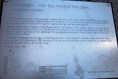
There's an explanatory plaque next to the marker. It says:

"Tankstream - Into the cove ...
Lynne Roberts-Goodwin

The Tankstream Artwork, in five separate locations from Pitt Street Mall to Alfred Street, marks the existence of the historic Tank Stream bubbling below the city streets. The subterranean movement of a fine stream of fresh spring water is conveyed through the rippling blue light and accompanying text.

Captain Watkin Tench, Captain of the Marines of the First Settlers at Port Jackson, wrote in his diary about the selection of Sydney Cove as the site for the first settlement. He recorded the presence of water at this site, his vision of grandeur of the settlement, the geographical description of the Sydney valley and the rise and flow of the stream.

Tankstream celebrates the memory of the original stream which started in the marshes where the Pitt Street Mall is now situated, its importance in the founding of the city, finally flowing into the harbour at Circular Quay.

Installed: June 1999"

Dunno about the rippling blue bit. The textured bits of the markers looked rippled but they're too grubby from foot traffic to be blue. They're nice anyways.


Hunter Street at the corner of Pitt Street Sydney

Hunter Street at the corner of Pitt Street Sydney.

On the Tank Stream underground tours the guides can tell they're near Hunter Street because the manhole covers rattle with the traffic.
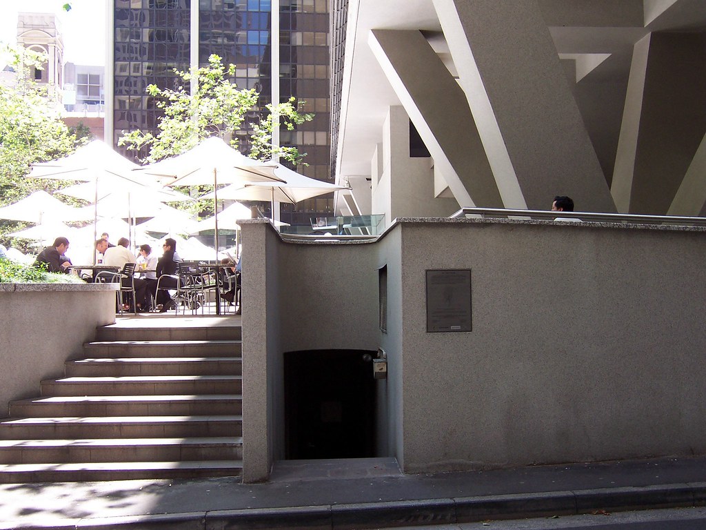

Tank Stream tanks & marker plaque Curtin Place Sydney
Biggulate

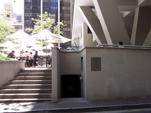
Marker #3. Curtin Place, off Pitt Street next to Australia Square.

The tanks are under Australia Square. When the Tank Stream ran dry or low in drought Governor Philip ordered "tanks" cut into the sandstone bed of the stream to trap more water in the next good flow.

The tanks cut into the sandstone base of the Tank Stream are under Australia Square, which is up those stairs.


The Tank Stream plaque

Down the stairs (bottom centre) beside the wall plaque is restricted access to the Stream. The plaque says:
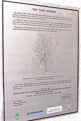

"THE TANK STREAM

On January 26th, 1788, Governor Arthur Phillip landed on the shores of Sydney Cove. The selection of the site for the colony was influenced by the availability of a supply of fresh water from what became known as the Tank Stream.

In 1790 the "tanks" from which the stream took its name were excavated in solid rock on both sides of the stream, close to the location of this plaque. The stream enetered the Cove at what is now Circular Quay and provided the colony with water until the early 1820's.

The growth and development of the city during the middle of the 19th century led to the stream being progressively covered and now it carries stormwater.

(Under the map:) Original course of the Tank Stream and the boundary of its catchment superimposed on the area today.

This plaque acknowldges the gift to the people of Sydney of public access to the Tank Stream by the Water Board, Lend Lease Corporation and the New South Wales Bicentennial Secretariat.

Unveiled by the
MINISTER FOR LOCAL GOVERNMENT, MINISTER FOR WATER RESOURCES & ASSISTANT MINISTER FOR TRANSPORT,
The Hon. Janice Crosio, M.P., on February 17th, 1988."

From Martin Place, walk down Pitt Street, past Hunter Street and into Curtin Place right before Australia Square. You're looking for an ordinary service access thingy next to the steps up to Australia Square's fountain.

While you're in Curtin Place, look at the shape of it. By this time on the walk you can see you're in the shallow narrow gully that carries the Tank Stream.


Tank Stream Bar off Pitt Street Sydney

Tank Stream Bar in Tank Stream Way, off Pitt Street just past Australia Square. A watering hole over a stream. Very appropriate.


Tank Stream marker cnr Bridge Street & Tank Stream Way Sydney
Biggulate

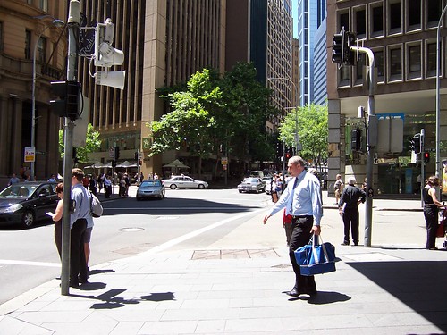
Marker #4. Bridge Street at the corner of Tank Stream Way. Tank Stream Way is an L-shaped lane from Pitt Street to Bridge Street.

That's the marker just under Blue Shirt's feet and the end of Tank Stream Way behind him.

Bridge Street may be the site of the original bridge over the Tank Stream. I'm pretty sure of that but I'm too buggered to check.

Children's Fountain Herald Square Alfred Street Sydney

Marker #5. The Children's Fountain, Herald Square, Alfred Street, which is the street that runs along in front of Circular Quay, to the right of this photo.

The Children's Fountain plaque

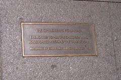
The Children's Fountain plaque, in the pavement next to the fountain in Herald Square, Alfred Street. Which is the street along the front of Circular Quay. It says:

"The Children's Fountain

Dedicated to all the children who have played around the Tank Stream.

Presented by John Fairfax & Sons Limited, 1981".

Platypus on Children's FountainSpider on Children's Fountain
Frill-necked lizard on Children's FountainEchidna on Children's Fountain

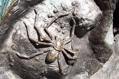
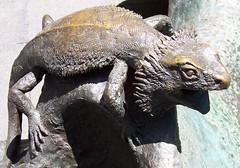
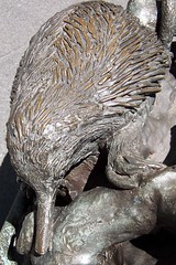
A few of the animals on the Children's Fountain. Platypus, spider, frill-necked lizard and echidna.

Circular Quay, train station & Cahill Expressway from the Commissioner's Steps Circ. Quay Sydney
Biggulate

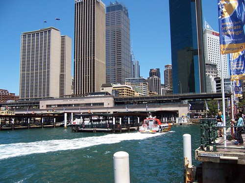
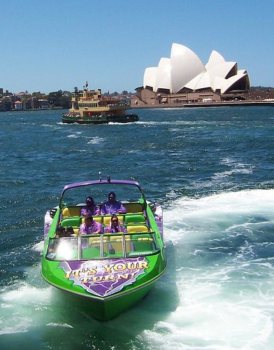
Circular Quay is Sydney Cove, the place where the First Fleet came ashore when they found fresh water in Port Jackson. They set up camp there and from that camp Sydney grew.

Where that orange and white boat is heading is around where the Tank Stream comes out, in its current incarnation as a stormwater drain.


FactFiles has some good pictures of the Stream's history.


Hope this post makes sense. Too tired to tell. Been a long day. It was good to get a walk in though and particularly to do the Tank Stream. I'm looking forward to doing it underground. That'll be a while. The tours are only twice yearly and there's a waiting list.

By the way, I’ll be swapping to Tuesday and Thursday blogging for a bit instead of Monday, Wednesday, Friday. Lotsa offline crap to be done at the moment.

Friday, November 16, 2007

Jacaranda Avenue

Back on deck. Feeling like I've been slugged in an alley but that's the flu for yer. Managed to totter out for a walk this morning. Bloody hot day for it.


Naroo Road Umina

Naroo Road. Tiny street off Veron Road in Umina, near the High School. A favourite site at this time of year. Locals often refer to it as Jacaranda Avenue.

The jacarandas are still in flower all over the Peninsula. Love their soft trumpet-shaped flowers and their warm soft honey scent.


Lion Island from Ettalong Beach

Hot and hazy day on the Coast. That's just low cloud or leftover mist hanging over Sydney, not smog. Been foggy up and down the NSW coast for a few days.

Taken from Ettalong Beach, near the dunnies at the end of Picnic Parade.

Left to right: Wagstaffe (closeest), Barrenjoey Head (distant), Pittwater (most distant), Lion Island (right of centre), Commodore Heights in the Ku-ring-gai (behind the Lion), Ettalong Beach (closest) and Mt Ettalong (behind it).


Pop over and have a gander at this wee old house on Mullet Creek. A Umina resident has snapped it from the train.

Mullet Creek is an offshoot of the Hawkesbury River, which is one of the branches of Broken Bay. Woy Woy is in Brisbane Water and Brisbane Water is also part of Broken Bay. Mullet Creek is stoppered at its end by Dangar Island, which has electricity but only one car.

Rumour has it this house has no electricity nor running water. Dear God! It's rather pleasant though and is either a late example of Old Colonial Georgian (1788 - circa 1840) or Victorian Georgian (circa 1840 - c.1890). I plump for Victorian. The area wasn't built in until the 1860s from what I can gather.

To get home its residents would have to get off at tiny Wondabyne station("passengers for Wondabyne please inform the guard and alight from the rear door or the rear carriage") or row for 20 minutes from Brooklyn township.


Dangar Island map

Dangar Island is the red dot the arrow is pointing at. Mullet Creek is the wee offshoot of river rising vertically above it and half obscured by the name of Woy Woy.