Lovely day today for walkies and photos and I'm stuck inside with an aching gut and a pile of work I'm ignoring. Been off sick for days.

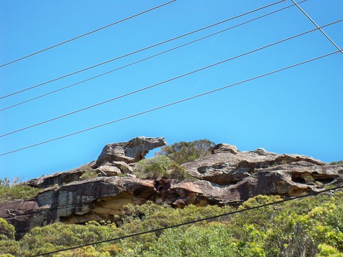
Bulimah Beach. Tiny wee beach, as you can see, tucked in between Putty Beach and Gerrin Point on the Bouddi peninsula. Or the Bouddi, as she is known locally. That's bood-eye not bood-ee and bood rhymes with hood not food.

Where the top photo's taken from. Beach Drive (lower) and Grandview Crescent Putty Beach/Killcare. Technically, the suburb is Killcare but who wants to live at a suburb name when they can live at a beach name?
Had a trot round the streets of Putty Beach/Killcare. This is every-street walkies I'm doing after all. Like anywhere with views, there's plenty of big pricey houses looming along the view streets but, like everywhere around Woy Woy/Brisbane Water, there's plenty of the nice quiet old places left.

Just for pretty. Hill-top above Grandview Crescent Killcare/Putty Beach.

This nice quiet old place looks to me to be the perfect place to walk home from the beach to.
After a nice long day messing about at the beach, you'd plod along the road in yer thongs, lairy beach towel over yer shoulder, head down and a fine crust of salt still drying on yer skin. Along the road with the banksia trees all along one side, up a bit of a hill, through a lane, round a corner and there's home ahead of you. Cool shady veranda with its scatter of old dogs and deck chairs. There's icy cold lemonade in the old Kelvinator and and there'll be chops and mashed potatoes and peas for dinner to finish off a splendiferous summer's day.
Heaven.
Bonus photo: On the beach (sand, surf, peeps, dogs, `nother view of Bullimah Beach)
Is it is or is it ain't?

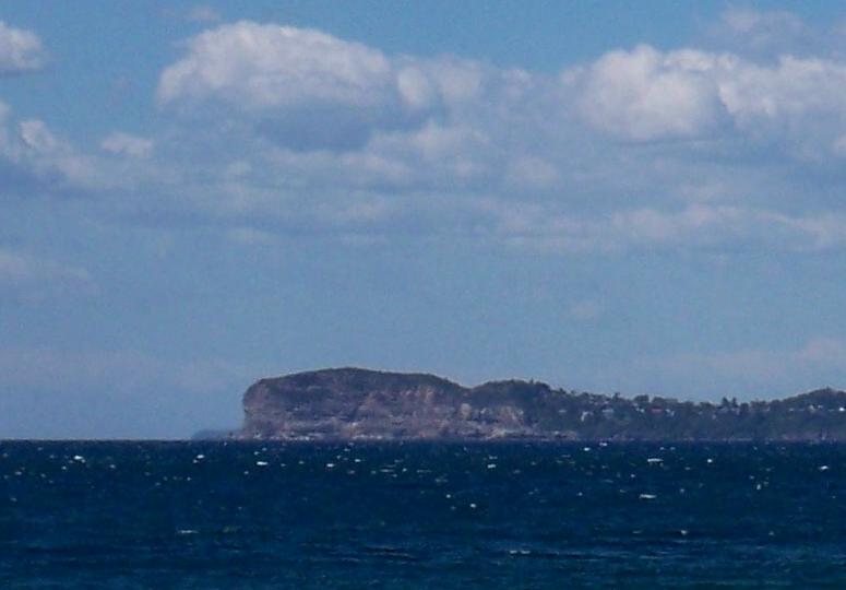
This is a close-up of the view photo from the Putty Beach post. Much more detail at this size. I got a new camera but it's only a PLC (pissy little camera) with 10MP res so this much detail means the thing is pretty close.
Hmm. Look at that wee faint headland to the left of the big clear one. Didn't notice that bit before.
So, is this big cliffy bit Manly/North Head or the Careel Headland or Long Reef? Opinions vary.
Okay, opening up the map of Sydney. Getting out ruler to check out this "Manly is only 30 kays" (18.64 miles) business... Hmm.

Bangelly Head (Careel Headland Res) is tall enough to be the close one. Long Reef is long but would not be visible from the Putty Beach angle. Manly is tall enough and cliffy enough and sticks out far enough but has gotta be the wee faint headland furtherest away.
Looks like it's Careel and Manly. Michael and Steveo win this debate and the admiration of their peers.
`Course when Michael goes up there to see what it says at Gerrin Point look-out, it might be a whole `nother debate.
Manly stuff
While we're on the Manly/North Head subject, we may as well have a gander at some links and a factoid.
In WWII there were fortifications up there. North Battery on North Head had two 9.2 inch Mk X guns, the Shelley Battery (Shelly Head, Manly) had one QF 12 pounder gun and, across the other side of the mouth of the Harbour, the Signal Battery on South Head had two 6 inch Mk XI guns.
Manly Ferry photo, factoids & video
North Head Quarantine Station (outsides & insides of buildings)
Quarantine Station factoids
Old photos of the Quarantine Station (And old rock carvings made by the quarantined)
Manly (harbour side) factoids & photos
Manly Beach (north side) photos & factoids
Enjoy. I'm off to lay with my feet in the sun and an icy cold lemonade in my hand.
5 comments:
It's the wrong 'shape' of landform to be North Head, nor Long Reef. I would assume it to be Careel.
Careel Headland is the most prominent bit you can see there , the tiny bit poking out is North Head , dont forget North Head is 30 k away where Careel Headland is around 15 - 17 ish , like I said in my previous remark , Killcare Beach and Maitland Bay are clearly viewed from Darley St Manly ( on a clear day with a good telescope ) you would probably get a small view of Long Reef as well if you walked to the other end of the beach , Google Earth with it's 3D terrain model shows it quite well , also North Head from the Manly side isn't as "cliffy" as such , Careel Headland is much higher in fact
I drink Bourbon lol
Somehow when I think of Manly Debates, I'm reminded of stupid tv commercials from the '80s.
"Tastes great!"
"Less fililng!"
"TASTES GREAT!"
"LESS FILLING!"
Loud grunting
LOUDER GRUNTING
Etcetera
I went to Marie Byles Lookout this morning just near killcare I had a look at the photo map they have there and according to that the headland thats in the very background of your photo spike IS north head and the headland in the foreground IS bangalley point
I took some photos while i was there and i just put them up on my flickr
Mal, all I can remember about the shape of North Head is it's cliffy. Last time I was there it was pissy down raining and there was a howling gale and the Quarantine station didn't look so much haunted as it did wet.
Stevo, you get some bloody good views in your job. All I get is a view of the wall behind the monitor.
*envies*
Suzanne, reminds me of scary 70s ads for Claytons.
Excellent to see you back on the internets BTW.
Michael, hav e linked you.
Post a Comment