New computer's buggerising around, by the way, so this won't be a very talky post.

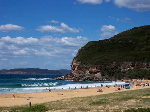
Through the banksias and pigface to the sand.

Putty Beach is an ocean beach. That's the Tasman Sea right there.
Ettalong Beach is an estuary beach but Putty Beach is on yer actual coast proper, on the edge of the Tasman. Which is between us and Kiwiland (New Zealand) and at the bottom of the South Pacific Ocean. (Mappage at end of post.)

Anyways, it's a beach. From it you can see Barrenjoey Head, where the lighthouse is. Squint a bit and you can see it in this photo. White job with a bit of red.
You can drive to Putty Beach from Ettalong, over The Rip Bridge, along Empire Bay Road, right into Wards Hill Road, right into The Scenic Drive, round two hairpin bends, left into Beach Drive and down to the carpark at the end. You can a bus there from Woy Woy station. In the Christmas holidays, you can get a ferry there, the old Cockatoo ferry.

A few people told me that big cliffy bit there on the left is Manly/North Head but it looks way too close to me. On the other hand, I got no idea what it is so maybe they're right.
North Head is one side of the mouth of Sydney Harbour. The Manly ferry (the biggest of the Sydney ferries) goes across to the inside part of North Head, the Manly part. It goes fairly close to the mouth of the harbour and when the sea is really big the Manly ferry gets cancelled. (Mappage at end of post.)

Putty Beach, Hardys Bay, Barrenjoey Head, which way to Sydney.

Manly, North Head, Sydney Harbour and which way to Woy Woy.
More maps

American readers note that this is a thong. Now you can see why we giggle when you talk about wearing thongs on yer bums (butts).
Random linkage
Links I've been meaning to link to for yonks. Don't even remember what half of them are. Consider them a lucky dip.
Ferries of Sydney (ferries, obvs)
APSCCG (native plants photos & factoids)
The sport of A-to-Zedding (some to do with maps?)
Cactus Bones (pretty pictures)
Bloody sidebar is still in semi-exile at the bottom of the site. Fucked if I can find the code for how to get the bastard back where it was.
6 comments:
Welcome back spike
I dont think that is north head/manly either i am looking at a map of sydney and it looks like it could be just south of whale beach which is next beach down from palm beach
manly doesnt look like irt sticks out that far
wb Spike , when I work at Manly in Darley St I am up 8 storeys and with the aid of the clients telescope you can get a nice view down to Killcare Beach and Maitland Bay , so that is North Head most protruding with the lower headland being Long Reef
sorry steve but i dont think it is its too close
"American readers note that this is a thong. Now you can see why we giggle when you talk about wearing thongs on yer bums (butts)."
Ah, this isn't an American thing, it's an Australian thing — it's much of the rest of the English-speaking world laughing at Australians for wearing thongs on their feet….
You could be right there young Micheal , it's hard to tell from the size of the pic , I refuse to further this debate until I have the original pic lol
From Google Earth the first big headland in the line of sight is Careel Headland , Long Reef then North head so you could well be right , the 3D terrain doesnt give real good look at the landform,
As the crow flies North Head is only 30 km away , thats Woy Woy to East Gosford and back not that far really
I was only going off the maps in the UBD street directory for sydney
I am pretty sure that up at the lookout just past killcare there they have a map that tells you what you are looking at- may have to go up there and have a look
Post a Comment