Annotated version & large version (not annotated).
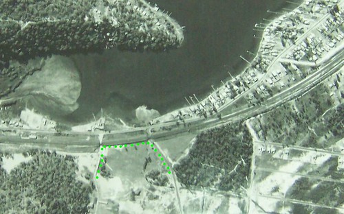
Aerial photo taken in the 1960s or 70s of the Woy Woy South/Correa Bay area of the Peninsula. Look at how much empty land is still there. Mostly gobbled up now by houses.
The area marked in green was once a paddock with a scout hall on it. Now it's a Home for the Terminally Bewildered. The scout hall however, is marked on my street directory as still in existence, at the Shoalhaven Drive end of this area.
On a sixties town planning map, the marked area is down as "R 66258 FOR FUTURE PUBLIC REQUIREMENTS". Public requirements certainly fits with a HftTB.
Blogged the HftTB in February. Michael lent his long-time local knowledge and told us that area was once a horse paddock with a "crumbling scout hall" in it and his mate lived behind it. Can you spot your mate's house, Michael?
That curved road going right across the photo is 2 roads and the railway.
On the left edge of the photo, the railway goes under the hill, alongside Mullet Creek, past Wondabyne & Brooklyn, over the Hawkesbury River and down into Sydney past the Ku-ring-gai National Park.
Also on the left edge, Woy Woy Road loops and wiggles up to the F3 to Newcastle and the Old Pacific Highway. Just out of the frame on the right it peters out.
Cross the level crossing just before it does and Railway Street, the 2nd road there, takes you all the way into Bustling Downtown Woy Woy. Which is all of five blocks from the outskirts. It ain't a big town.

The Home for the Terminally Bewildered on the old paddock. Locals will see it as they come through the underpass onto Railway Street.
Anonymous gave us some detail on the HftTB, telling us the place consists of "6 "cottages" each with about 14 residents. Nice big rooms, cosy fireplace in winter, kitchen and laundry, and gardens to walk in..." Sounds a pleasant place in which to spent one's declining years.
He or she also tells us "each cottage is named after a local shipwreck!" Check out the shipwrecks here.
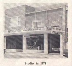
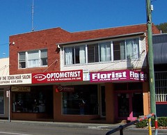
73 Blackwall Road Woy Woy in 1971 (left) and in 2006 (right). Part of Bustling Downtown Woy Woy. Locals, it's opposite Woolies.
You can see the balcony on the top right part of the 1971 building. And again on the 2006 building, bricked over in white. Now look at the pillars supporting the windows on both versions. Same. It's surprising how little some buildings change innit?
In 1971 it was Arthur Young's Studio and Photo Store. Now the upstairs flat looks like it's used for storage.
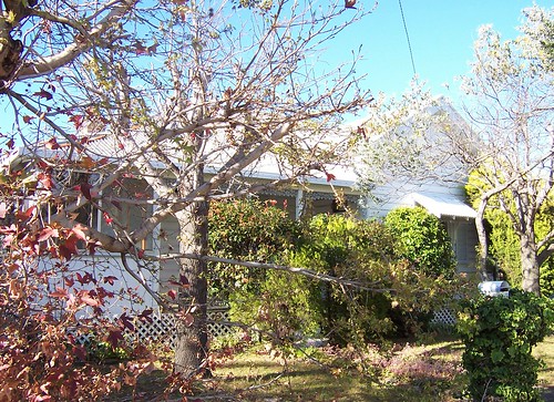
This is the hardest house to photograph in Woy Woy. It's a lovely old cottage near Rawson Road and in all seasons but winter it's hidden behind a row of flourishing trees.
It's hard to see its foundations and so on but the roofline, the width of the windows and the general style suggest circa 1900, which is the Federation period.
Okay, peeps, that's it for today. I'm all blogged out and not sure I'm making much sense anyways.
15 comments:
P.S.
Thanks to Michael for the 1971 picture.
Ooh, ariel photos give me vertigo. Perhaps it's a good job Broom rarely manages more than 300m in altitude...
Sorry I haven't visited for a while - Blame sunshine (yes, the UK had some last week!), and laziness (mine).
All is forgiven. I've visited yours but in stealth mode.
Also: sunshine? In Pommyland? Yer having me on!
my mates house is/was part of the housing commission, it mustve been built after this photo was taken as none of the houses are there
i forgot to ask where you got that aerial photo from?
My dad still has a bunch of large hi-res 1960's aerial photos of the peninsula — must see if I can find them next time I'm in Woy Woy. Yes, that part of Woy Woy was quite a scrubby wilderness in those days — I remember when they first put the dump up in the hills behind there, it was a bit like driving into the country to drop off the rubbish (they made a new road through the area). And I sure remember Arthur Young's studio, but I don't think I ever had my photo taken there…
Michael, dead right. All that end of Railway Street, my notebook informs me, has nothing earlier than the seventies and a few eighties bits then that Home for the Terminally Bewildered.
Someone donated the photo but I'm buggered if I remember who.
Jimmy
My dad still has a bunch of large hi-res 1960's aerial photos of the peninsula
Yer making me jealous! Bet they show some cool stuff, including the old airstrip.
And I sure remember Arthur Young's studio, but I don't think I ever had my photo taken there…
You blocked out the trauma of being snapped in shorts pants!
i just remembered i have a picture of that area taken from hillview st in the early seventies that shows just a empty space it was from a photocopy of a old newspaper I will scan it and send it to you if you like?
before they put in the extension to railway street the dead end part of shoalhaven drive (next to my mates place) opened onto that road that goes under the little rail bridge
Yeah, I think the aerial photos do show the airstrip, or what was left of it at the time. I'll see if I can get my dad to scan 'em in sometime.
And "that road that goes under the little rail bridge" that michael mentions was still a dirt road when I were a lad in Woy Woy; it didn't really go anywhere.
Michael, scan received, thank yer kindly.
That area at the tip end of Railway Street and up to Veron Road was massive. Way bigger than it looks now. Looks pretty boggy in those photos. No wonder so many bits there are named after swamplands.
That Shoalhaven thing. Was the end of Shoalhaven sloped more gently then. It's a sharp drop nowadays.
Jimmy
I'll see if I can get my dad to scan 'em in sometime.
Yes pls!
it didn't really go anywhere.
It didn't connect to Woy Woy Road then?
shoalhaven drive was sloped more gently then and those houses that are on the opposite side werent there back in 82/83 when i was going to my mates house
I seem to remember that when I was living in Woy Woy (we're talking 1960's and 70's...) Shoalhaven Rd was an isolated dirt road that went under the railway and connected to Veron Road (? one of those roads around there, anyway), and was one of those shortcuts that locals used a bit when feeling adventurous. Not sure, but then again, in those days quite a few of the lesser roads on the Peninsula were either dirt or had no real shoulders, etc. Must ask my dad sometime...
And what's now "Nagari Road" (I think) to the tip didn't exist, or was just a cow trail through the bush :-).
i remember shoalhaven drive wasnt connected to veron rd then it was opened then closed again then opened up again permanetly when they decided to build houses there
Michael and Jimmy, thank yer, I love these wee snippets of info that slowly build up my picture of the Peninsula.
Jimmy, yep, Nagari's the tip road. Wanders off from the end of Railway Street.
Post a Comment