
Clicking leads to bigger photos
South-eastern side of Rileys Island
Rileys was once inhabited by a single family. The Rileys. They bought it in 1855 and built a house there and an oyster farm nearby. The house is long gone. Rileys is now a nature reserve and home to various birds and beasts and plants. The family still lives in the area.

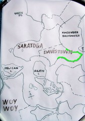
(The ferries crowd won't mind me nicking their map, I link them often enough)
Rileys Island is the green one just above St Huberts, the one with all the blasted canals.
Can't find it? Map with Rileys marked and another one.
There's not a lot of aerial views of Rileys. This one of St Huberts & most of Rileys looks like the best. You can clearly see the mangroves and the schlerophyll forest bits.

St Huberts Narrows between St Huberts (left) & Rileys Islands
A ferry will fit through there, as the ferries map above shows in a dotted line.
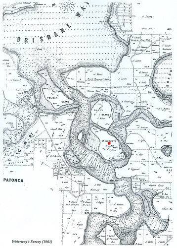
1901, St Huberts marked with red dot, Rileys above it
Rileys is not the only uninhabited island in Brisbane Water. All up, there's nearly a dozen islands and islets. Only St Huberts is inhabited by humans. Some of the islets are so tiny they are in danger of being washed away with the king tides.
The islands are pretty stable. They are Pelican Island, St Huberts Island (inhabited) and Rileys Island. You can see in the old maps they've changed shape a bit over time but there till there.
Rileys Stats
* Sold in 1855 as Shell Island to John Riley for 140 pounds, 17 shillings & sixpence
* 45 hectares in area (0.17 square miles in American)
* A ship called the Maggie Riley built there in 1878
* Two or three other ships built there in the 1860s
* The Riley family's oyster farm had "large slabs of flat ashlar stone...[stood] upright in the shallows near Riley's Bay"
* They also had "a few cattle [and] a banana plantation, using seaweed for fertiliser", on the island (History of Woy Woy)
* The island was made into a park June 1989
* Its flora (plants & trees) is mangrove swamp round the edges and dry schlerophyll forest in the middle
* The mangroves are Avicennia marina (Grey Mangrove) and Aegiceras corniculatum (River Mangrove)
* Before before us whitefellas came, the food available on and near Rileys was stuff like "shellfish, fruit, tubers, insect larvae, snakes, lizards and small animals...and speared fish with multi-pronged fish spears tipped with fish teeth or bones...Shellfish middens were so large that they were later excavated for a local lime burning industry that supplied lime for building works in Sydney." (Historical info on the Illoura Walk at Davistown)
Map showing main area of mangroves & adjacent oyster farms
St Hubert's & Riley's Islands
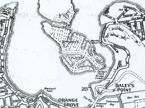
Check out the bridge sketched in between St Huberts (lower) and Rileys (cut off island). They were gonna canal Rileys as well as Huberts.
"During the 1960s efforts were made by Hooker-Rex Estates to develop canal subdivisions on both Riley’s Island and the adjoining St. Hubert’s Island. The latter island was eventually developed for residential use in the early 1970s, but a major environmental battle was waged to preserve Riley’s Island. This was ultimately successful, and Riley’s Island is now a sanctuary supporting a wide variety of fish and bird life." (History of Davistown includes 1854 map)
Rileys Island from Morton Crescent Davistown
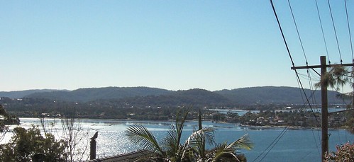
St Huberts & Rileys Islands from Blackwall Mountain
The reason I haven't shown you a photo of the whole of Rileys is the bastard is so hard to photograph. Even when you get a clear shot at it, the bastard melts into the background. It's not much easier to see with the naked eyeball. You gotta know what you're looking for.
Anyways, it's a bloody lovely bit of nature and I'm glad it wasn't canal'd and built on.
25 comments:
I was over at Davistown and Saratoga today took some photos with my mobile phone camera I was going to upload them to my flickr I also bought a usb cable to link from myphone to my computer and the bloody thing doesnt work - said it needed a cd for installation and it didnt come with one
When in doubt nick a screen grab while at Google Earth for those hard to get aerial pics .. Rileys Island on GE shows some interesting features from the air , like the old farmhouse site , old wharves and an excavation in the middle when they trialled a canal system there before they dug up St Hueberts
They also tried farming American Opossums there for some entirely strange reason , they don't like salt evidently - go figure !
Even from the photos you've posted, you can tell by the old pine trees someone used to live there a long time ago. Nice post - thanks!
Michael, bastards! Nice day for it though, the water was a lovely colour again.
Steve, d'oh! I forgot about Google Earth.
They also tried farming American Opossums
The mind boggles. Anyways, what's wrong with Straylyan possums?
Mal, I think it is the old house site. Strom said the wreck of it was still visible in the eighties.
Thank yer.
That pic with the rusting bouys in it is close to the old house site , on that side there was the shipyard , boathouse and a couple of buildings , it all was removed in the 80's
On the other side( facing Woy Woy) is where some old 1800's wharf stones remain and a skeletised Pine tree marking the first residence on Rileys in 1840
got my problem with the USB cable all sorted out now - all I had to do was download Nokia PC suite to my computer and its all working now
Steve said:
On the other side( facing Woy Woy) ...a skeletised Pine tree marking the first residence on Rileys in 1840
Looked for that pine specially the other day and couldn't see the bastard. Maybe it came down in the last wind.
Are the stones visible at low tide or are they a diving job?
Michael, giss your flickr URL again so I can get the bastard posted right this time.
This island was owned by my great grandfather (Daisley) who bought it from the Rileys in the early 1920-30s is think.
The original Rileys house was on the back of the island (the other side to the one with the rusting barge on the front - see pic)
On the front there were three main houses and a warf with a swimming baths area.
They were just on the right of where the old barge is sitting today.
The island was used as a farm and holiday place for years until it was sold to LJ Hookers who wanted to ruin it.
My mother and all her cousins grew up visiting the island going fishing and collecting mussels from the pilons of the baths.
I will post some photos when I can, but not much has been said about my family the second owners.
Duncan.
Duncan, me and my commenters and lurkers would LOVE to see some photos and hear some more stuff about Rileys. You know how people who don't own islands are.
Link me for local linkage or email me some images and stuff for an attributed post.
spikebotster [thingy] gmail [dottage] com
All very interesting. However here's some info that might fill in some gaps... My grandfather Donald Daisley actually purchased the island from the Riley familiy in about 1946, or there abouts. He bought it back then for 11000 quid. It was used by him and his 2 sisters, and his family. Donald had 4 children, all of whom used to spend a lot of time on the island. Donald later sold the property in the late 70's to a realter who later did a land deal to ensure it was kept a national park. Hope this info helps... Justine
To add to the information already stated by Duncan and Justine.
Riley's Island was purchased by my father Donald Daisley in 1946, after he sold a holiday house in Dailey's Point. He improved the Island with the building of holiday accomodation and tidal swimming baths, along with a grass tennis court, wharfs, shedding, and he built a retaining wall at the front out of trees cut down from the bush,and hand trimmed by a local, Sam Settrey, which the remnants of still remain. We had many holidays and great times on the island, fishing, swimming, boating, horse riding etc etc. He often invited friends and family to stay on the island, which they enjoyed immensely. Naturally they were all very disappointed when he, and my mother Sylvia decided to sell the island, because it was becoming too difficult to maintain. He also had many gardens,different animals such as,horses,cattle,ducks, geese,chickens etc. Naturally, everything had to be transported by water to the island, which sometimes had many funny stories attached.
The island was sold in 1960 to be developed by the purchasers Hooker Rex, with the plan to join it to St Hubert's island, and build canals and houses the same as on St Hubert's island. The development of St Hubert's destroyed the mangroves and ecology of the surrounding waterways, along with the breeding of many different species of fish and crabs, which created a solid case put forward by the Shire council for the prevention of the development of Riley's island.
It was later purchased by the NSW government to revert back to it's original natural state. It can be used by anyone who wishes to venture onto the island. It's a shame that they didn't retain the old Victorian weatherboard house, and have a caretaker look after the recreational aspect of the surrounding area, as the facility would add enormously to it's use. Ross
anyone have photos of the island when it was inhabited? also, where was the information that the excavation on the island was from a trial run of ideas for st huberts...
I used to camp there often in my early teens 1981-83 or so, taking my 2hp boat from Phegans Bay and around, setting up a tent or sleeping under the roof of the weatherboard house. We also camped on Gresco Island, the little island off Saratoga. Me and my freind Greg would fish all day, have a campfire and cook snags, and sometimes stay up to 2 weeks - going into Woy Woy for a wash and supplies. I remember well the stories we would tell about the place in those pre-internet days; was it - A secret chemical warfare station abandoned?. Haunted? Giant turtles that could eat a man in the ponds? :-)
I'm a descendant of John Riley who originally purchased the island. My grandfather Clarence Riley was a pioneer in the Peninsula with picture theatres and buses. Our family only recently sold his original home in Rileys Bay named Mount Earl.
In Oct 2014 my dad Quentin took us on a tour of Rileys Island and I can share some of those pics if someone can explain how I can do this?
Kind regards,
Virginia Riley
Hi Virginia, my name is Demi-Anne riley.. I’m at the great great great grand child of John Riley, my grandfather was Ronald “peter” riley.. if you would be able to get in contact with me I’d would love to know more about my family history.. my grandfather always told me story’s about how he grew up on Riley’s island with his mother and father ☺️ Kind regards.. my email is Demi.riley96@gmail.com
Hi Duncan my Dad (Neville) was a Cousin of Donald Daisley I had heard of the Riley island Daisley connection many times is it still owned by Daisley’s or has it been sold on we still live local but I remember uncle Donald and Aunt Sylvia when they lived at wilberforce on the horse farm. Love any info on the family
Hi Ross I’m obviously a distant relative would love any information on the family you may be able to let me know of I live local on the central coast
Ross I remember going to your mum and dads as a small girl to the farm at Wilberforce with my dad Neville would love to catch up on Daisley history
Can you please post them on facebook to good ol woy woy or the davistown group !
Interested in any photos
Reckon there will be any fish in there?
Many years ago my grandmother who was born in 1901 told me that as a schoolgirl she came for holidays on Rileys Is. I assume this would have been between approx. 1909 -1916. She talked about cattle roaming on the island and I believe some connection to the catholic church. I read on another history page that the 2 islands Rileys and St Huberts were purchased by Father Cornelius Coughlan and John Riley in 1855. I would love to find out more.
Very interesting read!
Hi
My dad frank was on council at the time of st huberts development. He and others tried to stop it due to the environmental devastation, loss of birdlike. They failed, but won the case with Riley's. So good to see as nature needs its reserve areas developers can't ruin.
It was the Green Ban imposed on the Island after the community groups had trouble convincing authorities to save it. It was in 1980 and I (Mike Campbell) was one of the delegates on the Central Coast Trades and Labour Council along with Morry Breen,Vince Murray,Kevin Baker,Guy Robins etc. hauled Hooker Rex into negotiations with Council etc. Eventually to the work of local Labor pollies the NSW Government puyrchased the site for a nature reserve.
Post a Comment