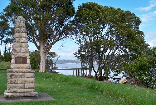
Marking a landing point of the exploration by Governor Arthur Phillip of the Port Jackson (now Sydney) colony.
Through the gap in the trees there you can see the footbridge and railway bridge from Woy Woy to Koolewong.
There was a metal plate on each side of the obelisk.
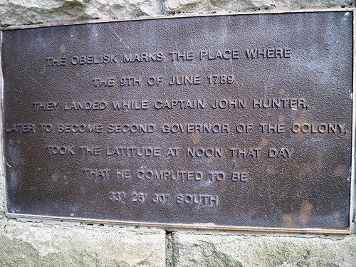
"The obelisk marks the place where
[On] the 9th of June 1789
They landed while Captain John Hunter,
Later to become second Governor of the colony,
Took the latitude at noon that day
That he computed to be
33 [degrees] 26' 30" South"
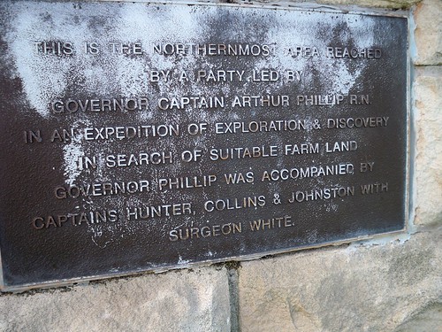
"This is the Northernmost area reached
By a party led by
Governor Captain Arthur Phillip R.N.
In an expedition of exploration & discovery
In search of suitable farm land
Governor Phillip was accompanied by
Captains Hunter, Collins & Johnston with
Surgeon White."
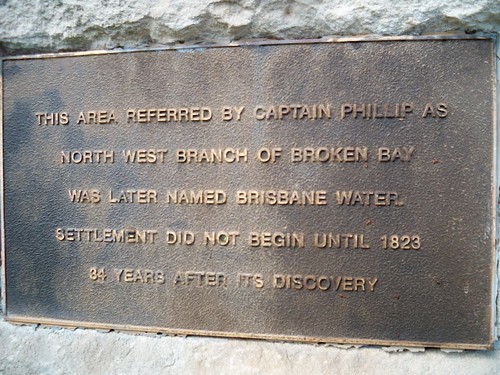
"This area, referred by Captain Phillip as
North West Branch of Broken Bay
Was later named Brisbane Water.
[White] Settlement did not begin until 1823.
34 years after its discovery"

"This spot is on the original grant of
640 acres of Crown land
Promised to John H. Edwards
By Sir Ralph Darling in 1829
And granted on 30.9.1839
To Major Henry Smyth who called it
GREEN POINT"
The plate at the bottom was the usual one saying the obelisk was bunged up in 1988 for the 200 year anniversary of the white settlement of Port Jackson (Sydney).

Point Frederick (Longnose) from Rocky Point at Green Point. Green Point is the suburb. Rocky Point and Ironbark Point are points within Green Point. Make sense?
Anyways, I am quite chuffed about getting this photo. Longnose is very hard to capture. It usually just fades into the background of the shore behind it. This time it was outlined clearly against the its background. Bloody lucky capture. Especially considering I've been trying for it since bloody 2005.
Its background this time is Point Clare and West Gosford.
Green Point mappage
Gov. Phillip thingies from the March 1788 visit at The Rip Bridge, Pearl Beach & St. Huberts Island.
Local linkage
Ferry news
Updated ferries timetable, includes putt putt day runs & footy ferry
Beach photo
Some of them anti-climate change peeps made a 350 on Umina Beach a couple of weekends back. Not entirely what it was for but apparently they don't like global warming. Fair enough.
The photo was taken from Mt Ettalong Road looking down on the eastern end (caravan park end) of Umina Beach.
Old photos
Golden Oldies want to see your old photos and memorabilia. November 11th at the Ettalong bowls.
"This is an informal day and encompasses local schools, factories and telephone exchanges pre-1960s ... With the passing of time our numbers are thinning and perhaps the pre-1970s would like to join us".
Contact details in local rag
No comments:
Post a Comment