Showing posts with label Green Point. Show all posts

Saturday, November 21, 2009

Green Point 1839

(Green Point walkies #5)

Pt Fred & West Gosford from Green Point

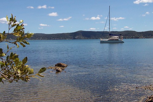
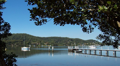
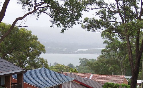
Always charge yer bloody camera before going walkies. I bloody well forgot and the bastard died on me one photo in. Nothing worked. No amount resting it, no amount of swearing at and threatening to gouge out its USB port with a rusty knife, nothing worked.

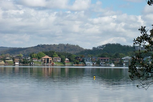
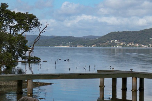
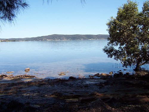
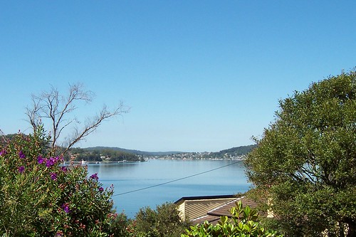
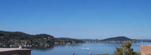
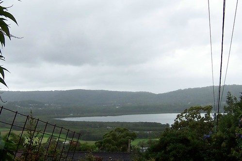
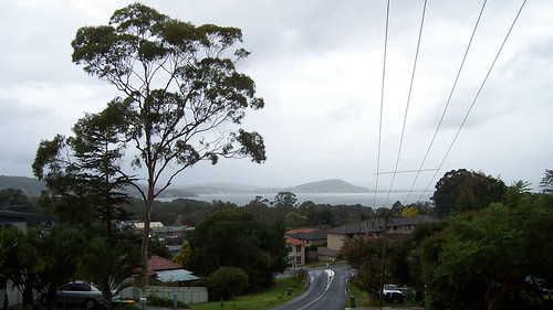
But the sky is blue and the water is a very nice shade. It was a warm day. Spring has not sprung this year and we've gone straight from a mild winter into a red hot summer.

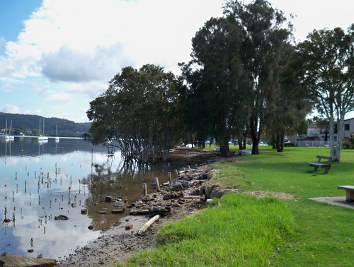
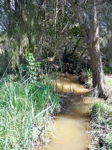
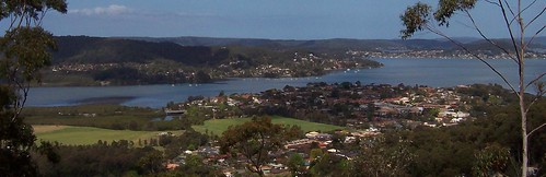
This was taken from a nameless laneway off Avoca Drive between Merindah Avenue and Edgewater Avenue, on the water side of Avoca Drive.
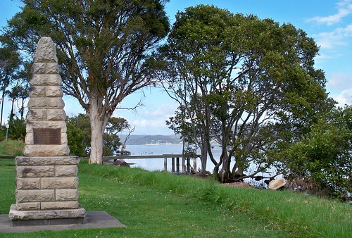

About Green Point

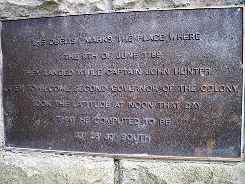
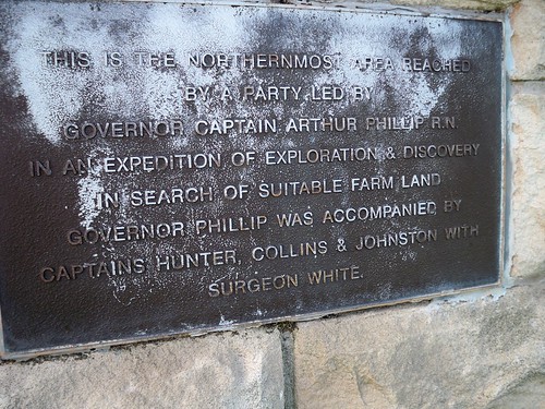
From the history obelisk thingo (Green Point 1789) we know when Green Point was settled by whitefellas and the name of the first one:

"This spot is on the original grant of
640 acres of Crown land
Promised to John H. Edwards
By Sir Ralph Darling in 1829
And granted on 30.9.1839
To Major Henry Smyth who called it
GREEN POINT"


The local history whatsit at the library has some stats:

"1788 - The true extent of the Aboriginal population in the Brisbane Water District is unknown, however it is estimated that several hundred people lived in the area before white settlement.

1823 - James Webb, the first white settler of Brisbane Water, takes up land at The Rip.

1828 - The Census of 1828 records approximately 100 persons in the Brisbane Water Police District, which included Lake Macquarie, Brisbane Water and Lower Portland Head. This figure did not record the number of aboriginal persons, however a census of aboriginals in Brisbane Water taken in the same year records 65 persons between the Hawkesbury River and Wyong. This figure is increasingly believed to underestimate severely the native population, which may have numbered several hundred.

1836 - 621 persons
...
1901 - 7,186 (Census)
...
1947 - 18,700
...
2001 - 161,204 - (Preliminary estimate)"

So 3 years before the major got his land, there was 621 whitefellas and perhaps the same amount of blackfellas living round the whole of Brisbane Water. Not what you'd call a crowd.

On the "1843 Brisbane Water list of Electors" a "Smyth, Henry (Major)" is listed as having "Freehold" on a property at "Broadwater".

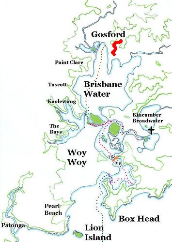
Bear in mind that "Broadwater" is not The Broadwater, up between Fagans Bay and Point Frederick on yer 2009 map of Brisbane Water, or even Kincumber Broadwater. It's a vague and confusing term that was applied to pretty much everywhere on Brisbane Water at some point in the past.

In Greville's Official Post Office Directory NSW - 1872 there's no-one listed as living at Green Point but some of the names on the list of locations don't exist anymore (the names not the locations) and some are extremely vague.

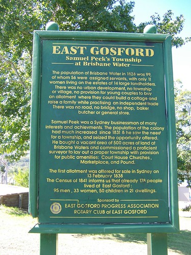
In 1882, waterfront land and big fat blocks were being sold at Green Point as "Suitable for Country Residences, Villa Sites and Farms".

In 1911, another land sale has a map of Green Point showing 2 existing waterfront cottages, Green Point Wharf, Green Point Post Office, three un-named streets and Avoca Drive down as "Kincumber Road". Looks like the 1882 land auction made bugger-all impact.

The un-named road leading to the wharf looks like the current Orana Street, just near the Bayside Drive lights.

Have yerself a gander at the Sub-division maps for Green Point and Kincumber, which borders on Green Point in the north.


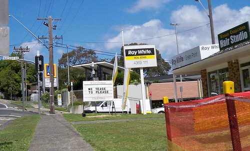
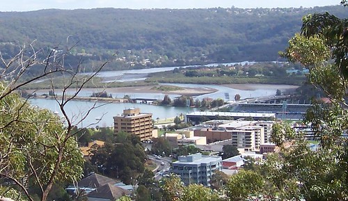
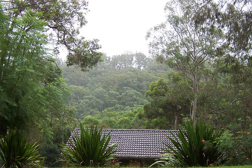
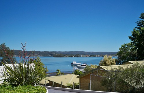
Nowadays Green Point is a thriving suburb-slash-village of the Greater Gosford/ the Gosford City Council area/ Brisbane Water district. Bustling Downtown Green Point is a supermarket, a bottle-shop (liquor store), a local history marker and a nice park, a teasing hair-dresser, a couple of estate agents and another shop I can't remember for the life of me.


Code Red

Most of New South Wales was on a total fire ban during the week, due to the drought and the wind and stuff.

Then the storms came on Friday and there were fires started here and there by lightning strikes. Nothing here, thank fuck, but summer ain't over yet. Hasn't even officially started.

Are you prepared to survive? - checklists & stuff at the RFS site

I've got me go bag sorted, like they said after Black Saturday. Photos, insurance policy, data back-up, towel, clean underpants. Grab and go.


Local linkage

My trek to Nepal - local bushwalker training for trekking

Kayaking Ettalong to Iron Ladder Beach - good photos, Iron Ladder is just near Box Head and the Palm Beach ferry goes quite near it.

Saturday, November 14, 2009

We tease to please

(Green Point walkies #4)

Asca Drive Green Point

Nice old weatherboard house on Asca Drive. Looks about 1900 to 1920s. But don't quote me on that. Can't find the book to check.


Stone piles Asca Drive Green Point

It had both brick piers (stumps) and stone ones but the stone ones are not original. They're too wide for their sheets of tin (to stop the white-ants). Original stone stumps are as narrow as these brick ones. Sometimes all the old stone piers on an old house get replaced, sometimes just some of them.


Road works on Avoca Drive Green Point

Green Point traffic is on a go-slow for a bit while they rip up bits of Avoca Drive (the main road) around Bayside Drive. Not sure what they're doing on this side but on the other side it looked like they were widening it.

Avoca Drive is one of the main roads of the Lower Central Coast/ Greater Gosford/ Brisbane Water area. If you're in Woy Woy and you want to go to Bloody Erina (Erina Fair, one of them big shopping centres) you go over The Rip Bridge to Daleys Point, along Empire Bay Drive past St. Huberts Island, Empire Bay, Bensville and Kincumber South, left onto Avoca Drive and through Kinumber, past Yattalunga, round and up through Green Point and right into The Entrance Road, past the barracks then right at Fountain Plaza and up Karalta Road and there you are at Bloody Erina.


We tease to please, cnr Bayside Drive & Avoca Drive Green Point

Stared at this sign for a good long while as I walked towards it. It looked like it belonged to the real estate agent and I wondered how the fuck teasing prospective home buyers was a good idea. Eventually I noticed the name if the hairdresser at the top of the sign. Jesus, I'm quick.


Mangrove stump in the shallows, Green Point

Just for pretty. Mangrove stump in the shallows.


Bonus photo

The Cockatoo ferry AKA Codock II

The lovely old wooden ferry at her mooring in Cockle Channel not far from Central Wharf (where you get off for the Davo) at Davistown.

She still does some runs over to Hardys and so forth. They changed the timetable again so I better get a new one. Haven't been on her for a bit. She's my favourite local ferry. Possibly my favourite ferry ever.


Google-botted

My stats are showing heaps of human and machine visits from Googlebot HQ. Must find out what that's about before I crash or something. Am I being checked out for some sort of fabulous feature thingy on the blogspot blog about blogspot blogs? The Inaugural Blogger Award for the Gratutious Use of the Word Fuck in a Walkies Context? Or maybe the googlebot just got the hiccups.

Saturday, November 07, 2009

Along the water

(Green Point walkies #3)

Memorial park at Orana Street Green Point

Starting point. Rocky Point in fact. Bottom of Orana Road.

To get to this park, come down Avoca Drive from The Entrance Road and turn right into Bayside Drive at the lights or Orana Road just after them.

If you're coming from Woy Woy, come up Maitland Bay Drive and over The Rip Bridge and up Empire Bay Drive to the wee stone church at the roundabout in Kincumber and turn left into Avoca Drive and go straight through Kincumber then up the hill and round and left into Orana Road just before the lights.


Houses on Point Frederick from Green Point

Wee old houses nestled between big flash houses on Point Frederick.

This is pretty much the same as anywhere there's big pricey houses along the water round Woy Woy and Brisbane Water and up and down the Central Coast. There's still some wee old houses from before the seventies, before the war and before the first war when land was cheap and there was fuck-all houses around Brisbane Water anyways.

It's like a miniature history of the Coast on one street. This particular street being Albany Street, the street running from stem to stern of Point Frederick AKA Longnose. In the background yer looking at Rumbalara Reserve (hill in shadow) and what appears to be Waterview Park AKA Presidents Hill above the trots in Gosford. Locals will know Presedents Hill as the hillside on which The Castle sits.


Green Point foreshore reserve

Bit of the park. It's a narrow strip of grassed land between the water and the houses with a private jetty and boat parked opposite nearly every house. Again, same all round Woy Woy and Brisbane Water.


Tall mangroves at Green Point

Some mangroves can get quite tall. These ones were about 15 metres (49.21 feet). Usually they're 2 to 6 metres (6.56 to 19.69 feet).


Tinny at Ironbark Point (near Green Pt)

The inevitable tinny.


Wee muddy creek at Ironbark Point (near Green Pt)

A wee muddy creek at Ironbark Point, about halfway up the park. Could be a storm drain all full after the bit of rain we had in October but it looked more creeky with the trees round it.


Scribbly gum bark Kenmare Road Green Point

Scribbly gum bark found in the wee bit of bush beside Kenmare Road. Scribbly gums are Eucalyptus haemastoma. The link has a good photo of the tree.

The scribbles are made by a wee tiny beastie, the larvae of the Scribbly Gum Moth (Ogmograptis scribula).


Bonus photo

Woy Woy/Koolewong footbridge from Green Point

Woy Woy to Koolewong footbridge as seen from Green Point.

Much clearer view of the footbridge. Couldn't find the bastard last week.


New new timetable

Local ferries timetable. Yep, same ferry as takes the Dear Old Things to the Davo.

I don't get paid for the local ferry adverts, by the way. I just love ferries.

Saturday, October 31, 2009

Green Point 1789

(Green Point walkies #2)

Governor Phillip marker Orana Road Green Point

Marking a landing point of the exploration by Governor Arthur Phillip of the Port Jackson (now Sydney) colony.

Through the gap in the trees there you can see the footbridge and railway bridge from Woy Woy to Koolewong.


Governor Phillip marker Orana Street Green Point

There was a metal plate on each side of the obelisk.

"The obelisk marks the place where
[On] the 9th of June 1789
They landed while Captain John Hunter,
Later to become second Governor of the colony,
Took the latitude at noon that day
That he computed to be
33 [degrees] 26' 30" South"


Gov. Phillip marker Orana Street Green Point

"This is the Northernmost area reached
By a party led by
Governor Captain Arthur Phillip R.N.
In an expedition of exploration & discovery
In search of suitable farm land
Governor Phillip was accompanied by
Captains Hunter, Collins & Johnston with
Surgeon White."


Governor Phillip marker Orana Street Green Point

"This area, referred by Captain Phillip as
North West Branch of Broken Bay
Was later named Brisbane Water.
[White] Settlement did not begin until 1823.
34 years after its discovery"


Governor Phillip marker Orana Street Green Point

"This spot is on the original grant of
640 acres of Crown land
Promised to John H. Edwards
By Sir Ralph Darling in 1829
And granted on 30.9.1839
To Major Henry Smyth who called it
GREEN POINT"

The plate at the bottom was the usual one saying the obelisk was bunged up in 1988 for the 200 year anniversary of the white settlement of Port Jackson (Sydney).


Point Frederick from Green Point

Point Frederick (Longnose) from Rocky Point at Green Point. Green Point is the suburb. Rocky Point and Ironbark Point are points within Green Point. Make sense?

Anyways, I am quite chuffed about getting this photo. Longnose is very hard to capture. It usually just fades into the background of the shore behind it. This time it was outlined clearly against the its background. Bloody lucky capture. Especially considering I've been trying for it since bloody 2005.

Its background this time is Point Clare and West Gosford.

Green Point mappage

Gov. Phillip thingies from the March 1788 visit at The Rip Bridge, Pearl Beach & St. Huberts Island.


Local linkage
Ferry news
Updated ferries timetable, includes putt putt day runs & footy ferry

Beach photo
Some of them anti-climate change peeps made a 350 on Umina Beach a couple of weekends back. Not entirely what it was for but apparently they don't like global warming. Fair enough.

The photo was taken from Mt Ettalong Road looking down on the eastern end (caravan park end) of Umina Beach.

Old photos
Golden Oldies want to see your old photos and memorabilia. November 11th at the Ettalong bowls.

"This is an informal day and encompasses local schools, factories and telephone exchanges pre-1960s ... With the passing of time our numbers are thinning and perhaps the pre-1970s would like to join us".

Contact details in local rag

Saturday, October 24, 2009

Green Point

(Green Point walkies #1)

Back. Somewhat refreshed from my holiday but shit continues to go down in my offline life so not really all that thrilled to be home.

Anyways. Green Point. Just before I went on holiday I started walking Green Point.


Green Point & Woy Woy

It's on the eastern side of the estuary (Brisbane Water) just above Yattalunga. It's a narrow strip of houses along Avoca Drive, squeezed in between the water and Kincumba Mountain.


Illawara Flame Tree

There's not much flowering this year due to the bloody dry winter we had. This is an Illaware flame tree, a baby one leaning over an overgrown creek (Egan Gully [Creek]) in Beatties Road which is at the bottom of the hill, right next to the christian school, just as you head up Avoca Drive into Green Point proper. It's a quiet road with just a few houses and a couple of eldery golden retrievers that wander out of their front yards and gaze up at you lovingly.


Stripy rock at Lexington Avenue Green Point

There's lots of places round Brisbane Water where there's flat rocks at the waterline. The park at the end of Lexington Parade and Merindah Avenue is one of those places. There's wee tiny rock pools and a scattering of broken shells and sea glass and, sometimes, stripy rocks where you can see how the sediment was laid down or whatever it was all those aeons ago. Cool.


Footbridge & Koolewong from Elfin Hill Rd Green Point

Can you see it? Locals should be able to pick up the shape of it. It's the footbridge over at Woy Woy/Koolewong, the one with all the wires. It's photos like this that remind me to get a new camera already. This one has reached its limits.


Tascott from Merindah Avenue Green Point

Just for pretty. Tascott and yacht. The other side of Brisbane Water always looks so far away in these photos I take across it. I swear it's not half that far.


Galahs in flight Lexington Avenue Green Point

I walked fuck-all of Green Point on my first walk there. Just three tiny streets. They all had a park at the end and I slothed out on the grass for a while. It was a warm day. We skipped spring this year and went straight into summer. I laid there under a tree listening to the breeze making the casuarina trees whisper in their soft howl and watching a couple of pink and grey galahs fossick about for something to eat.


Kayak season in Lintern Channel between Davistown & Rileys Island

It's kayak season. Some local crowd at Koolewong I think it is runs a kayak tours thingy where you go on a wee tour of the estuary in their kayaks. You see an occassional hardy kayaker out on the water in winter but it's summer that's the busy season and it's par for the course to see them bobbing in the wake of the ferry as it heads round to the stop for the Davo. (Get off at Central Ave, walk up Davistown Road and turn right at Murna Road.)

Weird to put the first photo last I know but there you go.


Holiday reading

I bring you leopard porn, the bad!fic that broke Wincon 2007. Olden but golden. From the fandom that brought you yak!crack.

*hearts the internets even though it should probably take its meds more often*

Saturday, September 27, 2008

Rumbalara Reserve

(Gosford walkies #35)

Green Point from Yaruga Look-Out Rumbalara Reserve Gosford
Reasonable resolution at bigger sizes (click it)

Green Point from Yaruga Look-Out Rumbalara Reserve Gosford

Green Point* is at the end of Kincumba Mountain, that flattish bulk of hill taking up most of the left side of the view. I have done no walkies there yet.

The area in the foreground is, on the left, East Gosofrd and Springfield. The big park along Erina Creek is Hylton Moore Park. The bridge is Punt Bridge. The right side of the foreground is East Gosford and Peeks Point.


Fagans Bay from Rumbalara Reserve Gosford
Resolution at biggest size is merely adequate

Fagans Bay from Rumbalara Reserve Gosford. The foreground is about half of Bustling Downtown Gosford. The two pyramids at the bottom are the courthouse at the corner of Henry parry Drive and Donnison Street. The curved street is Henry Parry Drive. On the right, halfway up the picture, is the footy oval, Grahame Park AKA Bluetongue Stadium. The blue block of flats is a block of flats. The beige block on flats on the left is the pebble-crete tower of the Gosford City Council on Mann Street next to the old conservatorium.

Feeling better yesterday so I went out for a bit of fresh air. Grabbed a mate and we walked down from the top of Rumbalara Reserve (the hill above Gosford).

Lovely walk. A faint breeze cooled our brows, the single notes of bell birds' calls reverberated in the gullies, the hillside was covered in spring fresh bracken and the tall thin trunks of the trees. There were plenty of wildflowers budding and blooming beside the track. It was an easy walk. Downhill for one thing but there was also steps and the occassional handrail. Just what the doctor ordered.


Putting Woy Woy on the map

i wish more people could tkae the time to do similar around the globe

They did, Vengaman, and are:

All Things Woy (another local)

World wide walkers
Catron County walk
Drew Kettle's 25,000kms
Fat man walking
New York City Walk
Strolling Round Socorro
Walking Berkeley
Walking Dunfermline
Walking Fort Bragg
Walking Hither Green
Walking Sydney streets
Walking San Francisco
Walking Turcot Yards


Oh, and if the Local Studies Librarian is reading, there is a large clear photo of the old Bay View pub in the upstairs office of the UFO.


* There's two. The other one's at Pearl Beach.

Tuesday, March 04, 2008

Peeks Point

(Gosford walkies #33, East Gosford)

My records say the last time I walked in Gosford was November 2006. Bollocks! More like November 2007.


View from Caroline Street Peeks Point
(Clicking leads to embiggening)

View from Caroline Street. Lovely clear day for photography today. Now that summer's over the rain has gone away.

Left to right: Rocky Point, Green Point/Kincumba Mountain behind it, Killcare in the distance, and Saratoga's Bayview Wharf area on the right.


Samuel Peek's Township at Brisbane Water

The sign reads:

"East Gosford
Samuel Peek's Township
at Brisbane Water

The population of Brisbane Water in 1828 was 99 [white people],
of whom 56 were assigned servants [convicts], with only 11
women living on the estates of 14 large landholders.
There was no urban development, no township
or village, no provision for young couples to buy
an allotment where they could build a cottage and
raise a family while practising an independent trade
There was no road, no bridge, no shop, baker
butcher or general store.

Samuel Peek was a Sydney businessman of many
interests and achievments. The population of the colony
had much increased since 1831 & he saw the need
for a township, and seized the opportunity offered.
He bought a vacant area of 500 acres of land at
Brisbane Waters and commissioned a proficient
surveyor to lay out a proper township with provision
for public amenities: Court House Churches,
Marketplace, and Pound.

The first allotment was offered for sale in Sydney on
13 February 1838.
The Census of 1841 informs us that already 178 people
lived at east Gosford:
95 men, 33 women, 50 children in 21 dwellings.

Sponsored by
EAST GOSFORD PROGRESS ASSOCIATION
ROTARY CLUB of EAST GOSFORD".

Bugger all remains to be seen of the original township. The houses there now are mostly 1940s and '70s with an occasional Federation cottage like this.


View from Caroline Street park Peeks Point
(Clicking leads to embiggening)

View from the park in Caroline Street.

Left to right: Ironbark Point (pair of yachts), Rocky Point, Green Point/Kincumba Mountain behind, Saratoga, and the water tank of Woy Woy Peninsula's Mount Ettalong on the right.

The water views were taken within an hour of each other and at pretty much the same angle from the sun, but check out how different the colour of the water is.


Ironbark Point from Russell Street Peeks Point
(Clicking leads to embiggening)

Looking across the water to Ironbark Point from Russell Street. Another quiet little bay in an estuary full of quiet little bays.


Red-tipped tree leaves
(Clicking leads to embiggening)

Red-tipped leaves on some sort of eucalyptus tree. Don't ask me what sort. I ain't no botanist.

Extra photo, didn't quite make the grade.

Thursday, February 28, 2008

Moody views

(East Gosford walkies #3 or thereabouts, map)

Purple & yellow flowers

The yellow flowers are everywhere around Brisbane Water, on large loose bushes. The purple ones are a climber that hangs over the wire fence along the railway line.

(Took this before the light went to hell. Right now it's gone all dark again, as dark as the third photo. Pissing down raining too. Been at it since all day. it nippy actually. Funny old weather for the last day of Spring. Usually I'd be blogging in me underpants and whinging about the heat.)

Anyways, I went into Gosford then tramped up and over Henry Parry Drive and into East Gosford. Went to a street there I'd seen from when I found the old quarry. Between it and the quarry is a small valley and across the valley I could see a street. So today I walked it.


View of Rumbalara Reserve from Bay View Avenue East Gosford

Rumbalara Reserve from Bay View Avenue East Gosford. Nice street Bay View. Not too badly infested with the 1970s buildings, bush and water views on one side, water views on t'other side, and bush up the back.


The Entrance Road & mangroves from Bay View Avenue East Gosford

This bay doesn't have a name in my 2006 street directory. Let's just call it Punt Bridge Bay because you can see it from Punt Bridge as you drive along The Entrance Road to Bloody Erina (Erina Fair).

The grassed bit on the lower left hand of the photo is Hylton Moore Park soccer oval. The trees around the bay are mangroves. The houses on the other side of the water are the Sun Valley Road area off Avoca Drive near Ironbark Point. The hills behind them are part of Kincumba Mountain.


View from Bay View Avenue East Gosford 1

The hill in a line with the road is Saratoga. The tree on the right of the photo is obscuring Woy Woy. The low bit to the left of Saratoga is Yattalunga. The hill behind is Killcare Heights (beyond which is the Tasman Sea).

Behind the tree in the left foreground is Green Point and Kincumba Mountain slopes off to the left edge of the picture.

The street was bloody steep. And it was raining. I muttered and grumbled and whinged my way up it. Turned round when I got to the top and had a look at the views. Bloody excellent. No doubt you could see all the way to Barrenjoey Head on a clear day but I rather like the misty views of a rainy day.


TS Hawkesbury & Point Clare from Bay View Avenue East Gosford

I particularly like this one from the other side of the road. TS Hawkesbury & Point Clare seen across The Broadwater, with Kariong and the ridges folding in behind on their way to Mooney Mooney Creek and the Great North Walk.


Fagans Bay from Bay View Avenue East Gosford

The Broadwater, Fagans Bay (right) and the houses along its southern edge. Fagans Bay is separated from The Broadwater by the railway line as it comes into Gosford from Woy Woy.

Up the top of the street it was flat and the houses were back from the road. The rain spattered on my brolly and the wind shook the tall gums. I could see Rumbalara Reserve across the valley and hear a bell bird in a tree somewhere. Despite being quite close to the traffic down on York Street, it was quiet and isolated.


Bay View Avenue East Gosford

Ignore the ferry routes. Look at the red wiggly line up the top. That's Bay View Avenue. It's way up on a ridge and the view from up there goes right down Brisbane Water.