I was wondering what the fuck I was going to blog about, still being too sick to go walkies, then I had a look at Steve's images relating to the
WWII emergency airstrip under Trafalgar Avenue.
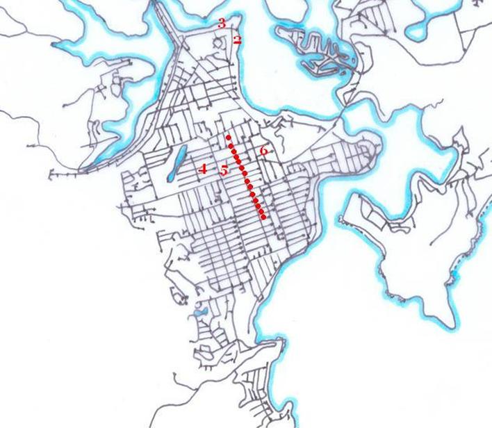
WWII emergency airstrip in Woy Woy (line of dots)
The numbers are possible locations for the "hideouts" mentioned in the secret document transcribed below.
Number 3 I think would have been where the Bowls is now, the one on the corner of "Wharf Road" (Brick Wharf Road) and North Burge Road. Number 2 I think exists today as the scout hall on the foreshore, about 200 metres from the bowls. Numbers 4 and 5 I think were using the proximity of the lagoon now in the golf course and
Paperbark Forest as extra cover.
First page of document reads:
"[Stamp, upper right corner]
18 FEB 1945
SECRET
[Stamp, upper right side]
Recieved DD
19 FEB 1943
[Document proper]
DEPARTMENT OF HOME SECURITY.
PRE-PLANNING SECTION.
REPORT BY W.H. GODFREY.: WOY WOY N.S.W.
Report prepared from inspection of site on 16th February
1943 with:--
P/O Roberst ( 1 D.W.O.)
Mr. Priddle (1 D.W.O.)
Mr O'Halloran( Department of the Interior).
Mr. Lipscombe( Com. Land Valuer).
and from D.W.B. drawing No. 42/43/491A. and aerial photographs.
SERVICE: Department of Air.
LOCALITY: WOY WOY N.S.W.
ESTABLISHMENT: Satellite (Schofields)
OBJECT OF VISIT: To review proposed hideout locations andtaxiways.
RECOMMENDATION:
Taxiways to Hideouts 1, 2, 3.
WHARF ROAD. To be retained as a taxiway. To be widened
on North side only. This widening to extend from Blackwall Road
to runway. Wharf Road, West of runway not to be used as taxiway
These alterations were principally giverned by locations
of electric light poles and other services.
Hideout No.1 to remain as on plan 42/43/491A
Hideout No.2 to have access from west side instead of
from east as on plan
Hideout No.3 to be resited close to and on North side
of Wharf Road 150 yards West of Hideout No.2.
Taxiway to Hideouts Nos 4, 5.
OCEAN BEACH ROAD. This will not now be used as a taxiway.
Hideout Nos. 4 and 5 have been resited as follows:--
Hideout No.4: on west side of and close to Ocean Beach
Road about 100 ft. North of Watkin Avenue,
Hideout No.5: 150 yards east of hideout No.4
access to these two hideouts, it is suggested, should be by
a Taxiway in direct continuation easterly of Watkin Avenue, connecting
with Trafalgar -Avenue, (i.e., the strip).
Hideout Nos. 6, 7, 8. Nos. 6 and 7 were too closely spaced for
existing policy. No.7 remains as on plan. No.8 remains as
planned but access will be from south instead of from North.
No.6 has been resited in good timber on S-W corner of Keith Street
and Springwood Street.
Taxiway 6, 7, 8. Access to these three hideouts should be
by constructing Albion Street from Trafalgar Avenue to Springwood Street
and a short portion of Springwood Street, between Ettalong Street
and Palm Street. (Palm Street is already constructed and built on and gives
access to town). A certain amount of additional grading to Springwood St.
should be included in the camouflage Scheme ( See Aerial Photos.)."
(First page of document ends.)
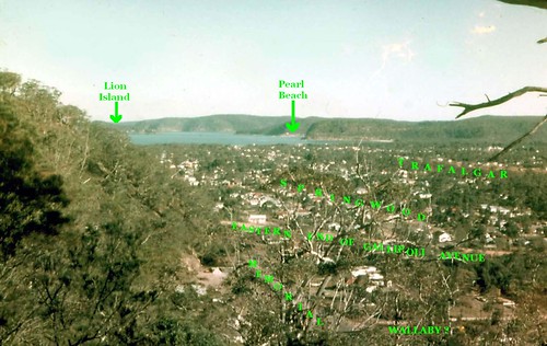
"Keith Street" does not now exist but I think it would be either the existing Warwick or Wallaby Streets, as they are tucked into the shadow of Blackwall Mountain.
"Ettalong Street" also does not exist now but I suspect it was what is now called Bangalow Street.
Locals (and
ex-locals) will be able to spot how much the area has changed from Steve's
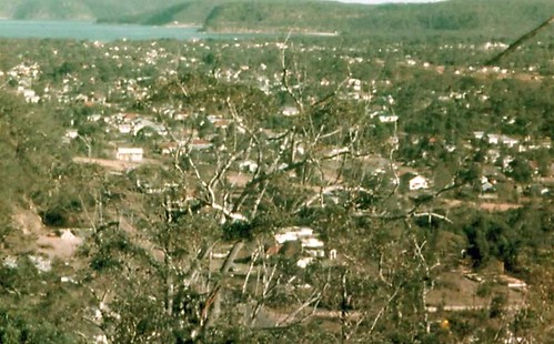
photo of the old strip overlaying recent shot of Trafalgar Avenue. For non-locals, I can tell you the trees around the strip in the photo are now almost all gone. A few venerable old gums still loom silently from people's backyards but the rest of the trees have been replaced with suburbia. But all is not lost! The gums still stand proud and wild on Blackwall Mountain barely 500 yards from the old airstrip.
Those secret 1943 documents are fascinating. Pretty much the top half of the Peninsula was going to be an airbase. The airstrip (runway) was built and so was a hangar in
Alma Avenue which is a short street running off Trafalgar Avenue near its north end.
Airstrips generally have their hangars (plane sheds) to the side of one end of the airstrip. This is for a few reasons. It's a short distance for taxiiing (driving the plane onto the runway), which saves time and fuel, if there's a prang chances are the pranging plane won't hit the hangars and total the other planes, as pranging planes are more likely to come off the runway around the middle of the strip rather than close to the end.
How much of the rest was built I don't yet know but I will be fossicking around in those spots with a fresh eye.
Steve also
talks about the WWII airstrip up at Tuggerah, about an hour's drive north of Woy Woy.
I'm looking at your aerial image, Steve, and reading this:
"in the centre there is a clearing in thick trees running north to south which is most probably the old strip"
I am inclined to think that's the one. An airstrip running north-south is much better than an airstrip running east-west in terms of dusk and dawn light-related landing mishaps.
By the way, I also liked your
night photos of Woy Woy. You've even made the carpark and the Vati-can look good!
DucktionaryA HD Fowler mailed me asking for permission to use the
Ducktionary as the basis for his "The Australish-ish Dictionary (TAD)."
He goes on "I intend for it to be a compilation of slang and "proper" Australian and New Zealand English words and phrases. English as it's used Down Under, if you will ... I liked what you had done so much, it's what I'd like to use for a starting point."
No worries.
Pseudodictionary.com at which the embryonic TAD is.
Pseudodictionary.com's board has a list of other Australian slanguage dictionaries, none of which I've read yet so proceed at yer own risk.
Right, that's it for today. My flu-enfeebled brain and bod are worn out from sitting on my arse using the keyboard. I'm off to enjoy the wind.