When I started I was so fucking unfit I made it round the block once. So I decided to walk every single street of the Peninsula.
I need powerful motivation to exercise regularly. Fitness itself is not enough for me. Martial arts had me exercising regularly and happily but I'd been too sick for that for two years or more. Came across Caleb Smith's New York Walk site and decided that was for me and I've been walking the streets ever since.
Caleb got to know Manhattan well by walking every single street and I've got to know the Woy Woy Peninsula well doing the same. Seeing every nook and cranny of it has really kept me going.
I've gone from once round the block and a four hour nap after (no exaggeration) to the Long March four months later and longer walks since. I had a month off between my 1st and 2nd walks due to six weeks of the flu and a few walks have been missed and the worst of summer has buggered me about but I've walked three times a week on average for a year.
I've walked all of the Peninsula and halfway round Brisbane Water. The heat's slowed me down a lot in the last couple of months but it looks like I'll get right the way round Brisbane Water by this time next year.
What will I do then? Keep going. This place is beautiful and there's a thousand more photos to take. I know it better than half the people who've lived here all their lives and I want to know more. I want to know every creek and bay and view, every street and lane and beautiful old house, every park and beat, every library and pub, every hill and ridge and brush turkey.
Autumn starts today and over the next few weeks the temperature will drop and the cold crisp mornings will be back. Great walking weather. I can power ahead again in the cold weather and get back to training for walking the Woy Woy to Gosford fun run in June.
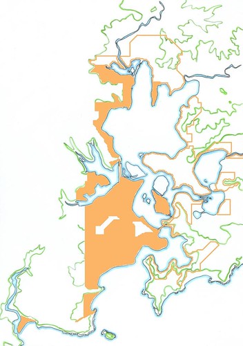
Orange outlines = intended walkies area
Orange blocked in = walked areas (blanks on the Peninsula are the golf course & Blackwall Mountain)
Green lines = hills & ridges
Blue lines = water features
Clockwise from bottom left:
Patonga, Pearl Beach, Woy Woy Peninsula (1st March - 29th September 2005)
The Bays (14th November - 19th December 2005)
Parks Bay (3rd October 2005)
Koolewong (22nd - 27th October 2005)
Tascott (1st - 11th November 2005
Point Clare (2nd - 16th December 2005)
West Gosford (21st - 29th December 2005)
Gosford & Point Frederick - top
Green Point
Yattalung, Saratoga & Davistown - double-headed peninsula
Kincumber (10th - 20th November 2005, 14th February 2006, unfinished)
Kincumber south
Bensville
Empire Bay
St Huberts Island (the only inhabited island on this map, 18th October 2005)
Daleys Point & Fishermans Bay
Hardys Bay
Killcare & Pretty Beach
Wagstaffe
19th century Sydney
Been trying to start this one for a while. Life is what happens when you're busy making other plans. But I'm determined to start it this winter.
My 19th century will start in 1788 (arrival of the First Fleet) and end in 1932 (completion of Sydney Harbour Bridge).
I'm going to begin at the place where you can see the Tank Stream. The Tank Stream was the only source of fresh water in the first few years of the colony and is an ideal spot to start. When I find it I'll start.
In the meantime, there's plenty of walkies in and around Woy Woy to be going on with. Bring on the cold mornings!
2 comments:
Wow. One Year anniversary. Is that really possible? Your dedication to the cause is an inspiration to me. I admire you so much I can even overlook your taste in music. (Honestly - Metallica?!)
Keep up the good work, Spike-o!
Can't hardly believe it myself. I've come so far, literally and in fitness. There's no stopping me now!
LOL re Metallica. I like the Pistols as well, does that redeem me?
Looking forward to your posts when you can get back to regular walkies.
Post a Comment