Saturday, December 12, 2009

Filthy dirty filking

(Random hung-over, Christmas-party fueled whingeing & filking*)

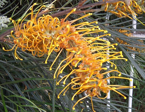
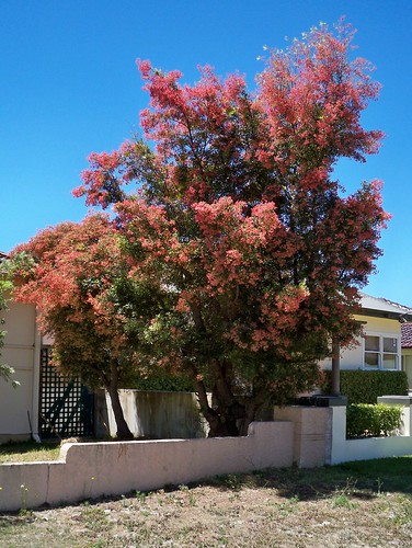
Christmas Bush AKA Ceratopetalum apetalum, Ettalong NSW December 2009

O Christmas bush
O Christmas bush
O Cerapetalum apetalum

In New South Wales at Christmas time
You come out in December heat

O Christmas bush
O Christmas bush
O Cerapetalum apetalum

With petals red and orange too
Only after pollination

O Christmas bush
O Christmas bush
O Cerapetalum apetalum


There's also Cerapetalum gummiferum which is the same until you get up close and see the leaves are arranged differently. And the gummiferum is pretty tall and "during World War II it provided the butts for all rifles made in Australia". Huh.


Off to my fourth Christmas party this week this arvo. May not survive. Normally I avoid office parties like the fucking plague but I called in a lot of favours this year and the payback is showing up as stand-in date. The next person to offer me a mince pie is dead.


Local linkage

Bike bunnies do Umina

Dickhead factor rockets during school holidays


Woy Woy as was

Love the photos and stories of old Woy Woy in the local rag. Woy Woy Steve is back writing them again and Fred Landman and Keith Whitfield are regulars and I've got one from June 2009 by Bruce Richards.

Sometimes the old buildings they talk about, old cinemas and milk bars and so forth, are gone now and sometimes they're just re-invented but I can usually see where they were or their remnants are. Adds a whole new depth to my walkies to have personal histories tied to the streets and buildings of my town.

Keep writing, guys.


Christmas story re-visited

How the angel got on top of the tree (click 'n' scroll)


Want my thingy in yer whatsit?

I'm off for Xmas. Off away from the madding crowd to a place where the bush turkeys roam free.

I'll be back ab-o-u-t ... Let's call it mid January. The 16th. Yeah.

Pick one or two of the thingies below for RSS or inbox pings or whatever.


Enter your Email


Powered by FeedBlitz


  • Atom


    Subscribe with Bloglines


    Have yerselves a merry little Xmas.


    * Filking ain't really dirty. I mentioned it to a Dear Old Thing one day and she reacted like it was a very naughty swear-word and now when I say it I get a naughty little thrill. It's that thing where you replace some or all of the words of an existing tune with your own words, like I did with Oh Christmas Tree. Go filk yerself (with links).
  • Sunday, December 06, 2009

    Up and down

    (Random Woy Woy walkies)

    View from Timbertop Drive Woy Woy

    Here we're looking north-east or east-north-east across The Bays (Correa Bay, Horsfield Bay, Phegans Bay & Woy Woy Bay) to Brisbane Water proper and the low part of Saratoga/Davistown and beyond that to Kincumba Mountain. Though it was Killcare/the Bouddi but the map says no.

    One blue-sky day in the last week synched with a day I was well enough to take the camera out. Got a mate to drive me up to a street with views, tottered out of the car, took a couple of snaps, back home again.

    Spent most of the week writhing round on the sofa in another bloody bout of bloody gut pain. No end of fucking fun. The rest of the week it was lovely and cool but way too cloudy for camera outings.


    Bark fallen from pink gum

    The bark falls off some of the gum trees at this time of year. You can see some of the bark in the cleft of this tree. The spots and dots and dimples of colour and texture where the bark has fallen away are normal.


    Chrissy is nearly upon us. There is a frenzy of shopping and barbeque-ing and getting off yer face on the weekends and the rest of it. Frankly, my dear, I don't give a damn.


    Local linkage

    Bloggers

    We've lost another blogger. Ian at Grumpy Old Journo. A local. He blogged from 2005, 4 years, same as me. He will be missed.

    But gained a blogger at Copa (Copacabana, a local beach).


    Others

    Bensvillians unite at facebook. And yes, that thumbnail is one of my photos.

    Photos of Woy Woy and Lion Island from the Kur-ring-gai National Park.

    Pop over to Bryan's family history page for a great old photo. Bryan is locally connected through Picketts and Humpries at Holy Cross Church/St. Joseph's in Kincumber.

    Other family historians with local connections are welcome to email me their website address for local linkage.


    The ferry news

    The Cockatoo ferry AKA Codock II

    Cockatoo ferry AKA Codock II AKA the lovely old one is running again. Timetables

    Sunday, November 29, 2009

    Drive-by

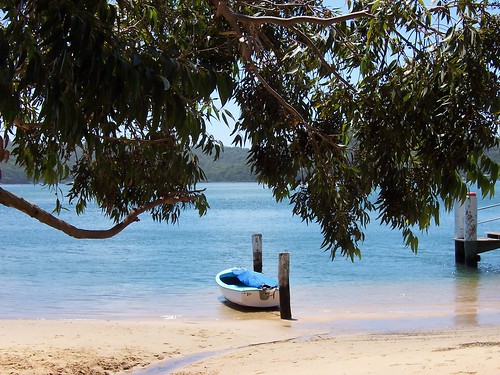
    Dingy at Wagstaffe Wharf Mulhall Street Wagstaffe

    Wagstaffe Wharf Mulhall Street Wagstaffe

    This is a drive-by posting. Been out all day and about to go out again. I am a wee bit drunk.

    Anyways, there was another bloody dust-storm today. My throat's as dry as a dead dingo's donger and that's after all the beer and some hideous cask wine. Will have a furry tongue in the morning.

    And I am fucking hating this evil early summer crap.

    That is all.

    And the photo is there because everyone likes it.


    Local lickage

    Coast not perfect but we love it, Pulse survey finds

    Saturday, November 21, 2009

    Green Point 1839

    (Green Point walkies #5)

    Pt Fred & West Gosford from Green Point

    Always charge yer bloody camera before going walkies. I bloody well forgot and the bastard died on me one photo in. Nothing worked. No amount resting it, no amount of swearing at and threatening to gouge out its USB port with a rusty knife, nothing worked.

    But the sky is blue and the water is a very nice shade. It was a warm day. Spring has not sprung this year and we've gone straight from a mild winter into a red hot summer.

    This was taken from a nameless laneway off Avoca Drive between Merindah Avenue and Edgewater Avenue, on the water side of Avoca Drive.


    About Green Point

    From the history obelisk thingo (Green Point 1789) we know when Green Point was settled by whitefellas and the name of the first one:

    "This spot is on the original grant of
    640 acres of Crown land
    Promised to John H. Edwards
    By Sir Ralph Darling in 1829
    And granted on 30.9.1839
    To Major Henry Smyth who called it
    GREEN POINT"


    The local history whatsit at the library has some stats:

    "1788 - The true extent of the Aboriginal population in the Brisbane Water District is unknown, however it is estimated that several hundred people lived in the area before white settlement.

    1823 - James Webb, the first white settler of Brisbane Water, takes up land at The Rip.

    1828 - The Census of 1828 records approximately 100 persons in the Brisbane Water Police District, which included Lake Macquarie, Brisbane Water and Lower Portland Head. This figure did not record the number of aboriginal persons, however a census of aboriginals in Brisbane Water taken in the same year records 65 persons between the Hawkesbury River and Wyong. This figure is increasingly believed to underestimate severely the native population, which may have numbered several hundred.

    1836 - 621 persons
    ...
    1901 - 7,186 (Census)
    ...
    1947 - 18,700
    ...
    2001 - 161,204 - (Preliminary estimate)"

    So 3 years before the major got his land, there was 621 whitefellas and perhaps the same amount of blackfellas living round the whole of Brisbane Water. Not what you'd call a crowd.

    On the "1843 Brisbane Water list of Electors" a "Smyth, Henry (Major)" is listed as having "Freehold" on a property at "Broadwater".

    Bear in mind that "Broadwater" is not The Broadwater, up between Fagans Bay and Point Frederick on yer 2009 map of Brisbane Water, or even Kincumber Broadwater. It's a vague and confusing term that was applied to pretty much everywhere on Brisbane Water at some point in the past.

    In Greville's Official Post Office Directory NSW - 1872 there's no-one listed as living at Green Point but some of the names on the list of locations don't exist anymore (the names not the locations) and some are extremely vague.

    In 1882, waterfront land and big fat blocks were being sold at Green Point as "Suitable for Country Residences, Villa Sites and Farms".

    In 1911, another land sale has a map of Green Point showing 2 existing waterfront cottages, Green Point Wharf, Green Point Post Office, three un-named streets and Avoca Drive down as "Kincumber Road". Looks like the 1882 land auction made bugger-all impact.

    The un-named road leading to the wharf looks like the current Orana Street, just near the Bayside Drive lights.

    Have yerself a gander at the Sub-division maps for Green Point and Kincumber, which borders on Green Point in the north.


    Nowadays Green Point is a thriving suburb-slash-village of the Greater Gosford/ the Gosford City Council area/ Brisbane Water district. Bustling Downtown Green Point is a supermarket, a bottle-shop (liquor store), a local history marker and a nice park, a teasing hair-dresser, a couple of estate agents and another shop I can't remember for the life of me.


    Code Red

    Most of New South Wales was on a total fire ban during the week, due to the drought and the wind and stuff.

    Then the storms came on Friday and there were fires started here and there by lightning strikes. Nothing here, thank fuck, but summer ain't over yet. Hasn't even officially started.

    Are you prepared to survive? - checklists & stuff at the RFS site

    I've got me go bag sorted, like they said after Black Saturday. Photos, insurance policy, data back-up, towel, clean underpants. Grab and go.


    Local linkage

    My trek to Nepal - local bushwalker training for trekking

    Kayaking Ettalong to Iron Ladder Beach - good photos, Iron Ladder is just near Box Head and the Palm Beach ferry goes quite near it.
    Saturday, November 14, 2009

    We tease to please

    (Green Point walkies #4)

    Asca Drive Green Point

    Nice old weatherboard house on Asca Drive. Looks about 1900 to 1920s. But don't quote me on that. Can't find the book to check.


    Stone piles Asca Drive Green Point

    It had both brick piers (stumps) and stone ones but the stone ones are not original. They're too wide for their sheets of tin (to stop the white-ants). Original stone stumps are as narrow as these brick ones. Sometimes all the old stone piers on an old house get replaced, sometimes just some of them.


    Road works on Avoca Drive Green Point

    Green Point traffic is on a go-slow for a bit while they rip up bits of Avoca Drive (the main road) around Bayside Drive. Not sure what they're doing on this side but on the other side it looked like they were widening it.
    Avoca Drive is one of the main roads of the Lower Central Coast/ Greater Gosford/ Brisbane Water area. If you're in Woy Woy and you want to go to Bloody Erina (Erina Fair, one of them big shopping centres) you go over The Rip Bridge to Daleys Point, along Empire Bay Drive past St. Huberts Island, Empire Bay, Bensville and Kincumber South, left onto Avoca Drive and through Kinumber, past Yattalunga, round and up through Green Point and right into The Entrance Road, past the barracks then right at Fountain Plaza and up Karalta Road and there you are at Bloody Erina.


    We tease to please, cnr Bayside Drive & Avoca Drive Green Point

    Stared at this sign for a good long while as I walked towards it. It looked like it belonged to the real estate agent and I wondered how the fuck teasing prospective home buyers was a good idea. Eventually I noticed the name if the hairdresser at the top of the sign. Jesus, I'm quick.


    Mangrove stump in the shallows, Green Point

    Just for pretty. Mangrove stump in the shallows.


    Bonus photo

    The Cockatoo ferry AKA Codock II

    The lovely old wooden ferry at her mooring in Cockle Channel not far from Central Wharf (where you get off for the Davo) at Davistown.

    She still does some runs over to Hardys and so forth. They changed the timetable again so I better get a new one. Haven't been on her for a bit. She's my favourite local ferry. Possibly my favourite ferry ever.


    Google-botted

    My stats are showing heaps of human and machine visits from Googlebot HQ. Must find out what that's about before I crash or something. Am I being checked out for some sort of fabulous feature thingy on the blogspot blog about blogspot blogs? The Inaugural Blogger Award for the Gratutious Use of the Word Fuck in a Walkies Context? Or maybe the googlebot just got the hiccups.

    Saturday, November 07, 2009

    Along the water

    (Green Point walkies #3)

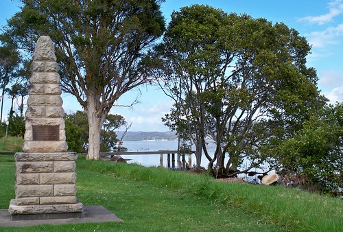
    Memorial park at Orana Street Green Point

    Starting point. Rocky Point in fact. Bottom of Orana Road.

    To get to this park, come down Avoca Drive from The Entrance Road and turn right into Bayside Drive at the lights or Orana Road just after them.

    If you're coming from Woy Woy, come up Maitland Bay Drive and over The Rip Bridge and up Empire Bay Drive to the wee stone church at the roundabout in Kincumber and turn left into Avoca Drive and go straight through Kincumber then up the hill and round and left into Orana Road just before the lights.


    Houses on Point Frederick from Green Point

    Wee old houses nestled between big flash houses on Point Frederick.

    This is pretty much the same as anywhere there's big pricey houses along the water round Woy Woy and Brisbane Water and up and down the Central Coast. There's still some wee old houses from before the seventies, before the war and before the first war when land was cheap and there was fuck-all houses around Brisbane Water anyways.

    It's like a miniature history of the Coast on one street. This particular street being Albany Street, the street running from stem to stern of Point Frederick AKA Longnose. In the background yer looking at Rumbalara Reserve (hill in shadow) and what appears to be Waterview Park AKA Presidents Hill above the trots in Gosford. Locals will know Presedents Hill as the hillside on which The Castle sits.


    Green Point foreshore reserve

    Bit of the park. It's a narrow strip of grassed land between the water and the houses with a private jetty and boat parked opposite nearly every house. Again, same all round Woy Woy and Brisbane Water.


    Tall mangroves at Green Point

    Some mangroves can get quite tall. These ones were about 15 metres (49.21 feet). Usually they're 2 to 6 metres (6.56 to 19.69 feet).


    Tinny at Ironbark Point (near Green Pt)

    The inevitable tinny.


    Wee muddy creek at Ironbark Point (near Green Pt)

    A wee muddy creek at Ironbark Point, about halfway up the park. Could be a storm drain all full after the bit of rain we had in October but it looked more creeky with the trees round it.


    Scribbly gum bark Kenmare Road Green Point

    Scribbly gum bark found in the wee bit of bush beside Kenmare Road. Scribbly gums are Eucalyptus haemastoma. The link has a good photo of the tree.

    The scribbles are made by a wee tiny beastie, the larvae of the Scribbly Gum Moth (Ogmograptis scribula).


    Bonus photo

    Woy Woy/Koolewong footbridge from Green Point

    Woy Woy to Koolewong footbridge as seen from Green Point.

    Much clearer view of the footbridge. Couldn't find the bastard last week.


    New new timetable

    Local ferries timetable. Yep, same ferry as takes the Dear Old Things to the Davo.

    I don't get paid for the local ferry adverts, by the way. I just love ferries.

    Saturday, October 31, 2009

    Green Point 1789

    (Green Point walkies #2)

    Governor Phillip marker Orana Road Green Point

    Marking a landing point of the exploration by Governor Arthur Phillip of the Port Jackson (now Sydney) colony.

    Through the gap in the trees there you can see the footbridge and railway bridge from Woy Woy to Koolewong.


    Governor Phillip marker Orana Street Green Point

    There was a metal plate on each side of the obelisk.

    "The obelisk marks the place where
    [On] the 9th of June 1789
    They landed while Captain John Hunter,
    Later to become second Governor of the colony,
    Took the latitude at noon that day
    That he computed to be
    33 [degrees] 26' 30" South"


    Gov. Phillip marker Orana Street Green Point

    "This is the Northernmost area reached
    By a party led by
    Governor Captain Arthur Phillip R.N.
    In an expedition of exploration & discovery
    In search of suitable farm land
    Governor Phillip was accompanied by
    Captains Hunter, Collins & Johnston with
    Surgeon White."


    Governor Phillip marker Orana Street Green Point

    "This area, referred by Captain Phillip as
    North West Branch of Broken Bay
    Was later named Brisbane Water.
    [White] Settlement did not begin until 1823.
    34 years after its discovery"


    Governor Phillip marker Orana Street Green Point

    "This spot is on the original grant of
    640 acres of Crown land
    Promised to John H. Edwards
    By Sir Ralph Darling in 1829
    And granted on 30.9.1839
    To Major Henry Smyth who called it
    GREEN POINT"

    The plate at the bottom was the usual one saying the obelisk was bunged up in 1988 for the 200 year anniversary of the white settlement of Port Jackson (Sydney).


    Point Frederick from Green Point

    Point Frederick (Longnose) from Rocky Point at Green Point. Green Point is the suburb. Rocky Point and Ironbark Point are points within Green Point. Make sense?

    Anyways, I am quite chuffed about getting this photo. Longnose is very hard to capture. It usually just fades into the background of the shore behind it. This time it was outlined clearly against the its background. Bloody lucky capture. Especially considering I've been trying for it since bloody 2005.

    Its background this time is Point Clare and West Gosford.

    Green Point mappage

    Gov. Phillip thingies from the March 1788 visit at The Rip Bridge, Pearl Beach & St. Huberts Island.


    Local linkage
    Ferry news
    Updated ferries timetable, includes putt putt day runs & footy ferry

    Beach photo
    Some of them anti-climate change peeps made a 350 on Umina Beach a couple of weekends back. Not entirely what it was for but apparently they don't like global warming. Fair enough.

    The photo was taken from Mt Ettalong Road looking down on the eastern end (caravan park end) of Umina Beach.

    Old photos
    Golden Oldies want to see your old photos and memorabilia. November 11th at the Ettalong bowls.

    "This is an informal day and encompasses local schools, factories and telephone exchanges pre-1960s ... With the passing of time our numbers are thinning and perhaps the pre-1970s would like to join us".

    Contact details in local rag

    Saturday, October 24, 2009

    Green Point

    (Green Point walkies #1)

    Back. Somewhat refreshed from my holiday but shit continues to go down in my offline life so not really all that thrilled to be home.

    Anyways. Green Point. Just before I went on holiday I started walking Green Point.


    Green Point & Woy Woy

    It's on the eastern side of the estuary (Brisbane Water) just above Yattalunga. It's a narrow strip of houses along Avoca Drive, squeezed in between the water and Kincumba Mountain.


    Illawara Flame Tree

    There's not much flowering this year due to the bloody dry winter we had. This is an Illaware flame tree, a baby one leaning over an overgrown creek (Egan Gully [Creek]) in Beatties Road which is at the bottom of the hill, right next to the christian school, just as you head up Avoca Drive into Green Point proper. It's a quiet road with just a few houses and a couple of eldery golden retrievers that wander out of their front yards and gaze up at you lovingly.


    Stripy rock at Lexington Avenue Green Point

    There's lots of places round Brisbane Water where there's flat rocks at the waterline. The park at the end of Lexington Parade and Merindah Avenue is one of those places. There's wee tiny rock pools and a scattering of broken shells and sea glass and, sometimes, stripy rocks where you can see how the sediment was laid down or whatever it was all those aeons ago. Cool.


    Footbridge & Koolewong from Elfin Hill Rd Green Point

    Can you see it? Locals should be able to pick up the shape of it. It's the footbridge over at Woy Woy/Koolewong, the one with all the wires. It's photos like this that remind me to get a new camera already. This one has reached its limits.


    Tascott from Merindah Avenue Green Point

    Just for pretty. Tascott and yacht. The other side of Brisbane Water always looks so far away in these photos I take across it. I swear it's not half that far.


    Galahs in flight Lexington Avenue Green Point

    I walked fuck-all of Green Point on my first walk there. Just three tiny streets. They all had a park at the end and I slothed out on the grass for a while. It was a warm day. We skipped spring this year and went straight into summer. I laid there under a tree listening to the breeze making the casuarina trees whisper in their soft howl and watching a couple of pink and grey galahs fossick about for something to eat.


    Kayak season in Lintern Channel between Davistown & Rileys Island

    It's kayak season. Some local crowd at Koolewong I think it is runs a kayak tours thingy where you go on a wee tour of the estuary in their kayaks. You see an occassional hardy kayaker out on the water in winter but it's summer that's the busy season and it's par for the course to see them bobbing in the wake of the ferry as it heads round to the stop for the Davo. (Get off at Central Ave, walk up Davistown Road and turn right at Murna Road.)

    Weird to put the first photo last I know but there you go.


    Holiday reading

    I bring you leopard porn, the bad!fic that broke Wincon 2007. Olden but golden. From the fandom that brought you yak!crack.

    *hearts the internets even though it should probably take its meds more often*

    Saturday, October 03, 2009

    My island home

    Got a walk to blog this week but will leave it for when I come back (24th October) in favour of looking at why Australia had two wee tiny earth tremors while Sumatra is a crumbling ruin and half Samoa’s kids were washed away in a tidal wave.

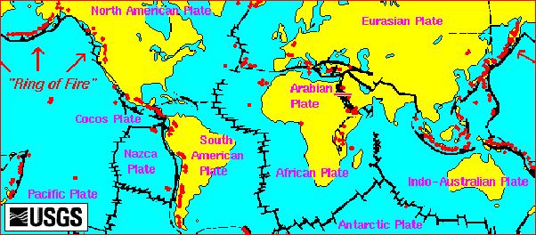
    Earthquake epicentres
    (Maps from Wiki Creative Commons)

    Those big black lines are where there’s frequent and/or bad earthquakes. Australia's got a fair few dots but this map shows all quakes from 1963 to 1998 not just bad ones.

    You can't even see New Zealand and New Guinea and Japan. That's how many quakes they have.


    World volcano map
    (Actually a volcano map but clearer.)

    Notice how the quake lines go round Australia and don’t touch it. New Zealand is over there to the right of Australia and down a bit, right on the edge. That line on it is why it’s known as the Shaky Isles.


    South-east Asia

    There’s been some medium-sized earthquakes in South East Asia (the green bits) over the past couple of weeks.

    Then there was the 8 off Samoa on Wednesday and the tidal waves from it hit Western Samoa (2 left dots), American Samoa (single right dot) and Tonga.


    Samoan earthquake epicentre

    Video simulation of the tidal wave from the earthquake

    Panic button


    South-east Asia

    Then a big quake hit Sumatra and pretty much wrecked it. They’re still searching for survivors in the rubble there. Not so much in Samoa now. Only bodies are being found there now.

    There’s a bit of a Samoan and Tongan community in Australia. Some of our best rugby players are from Samoa and Tonga and both are small countries that just don't have the resources to provide the bright lights big city thing yer average young adult wants.

    New Zealand also has a bit of a Samoan and Tongan community and so the same scenes have been on the news there as well as here: weeping anxious stunned people flying home to bury their families. One poor bugger showed a picture of her extended family. 21 of them were dead. That left 2 or 3 people in that photo alive.

    Tonga also got hit by tidal waves from the same earthquake. Less powerful waves but people were killed there too and there too the land was stripped and made barren by the sea salt dumped on it.

    Samoa lost a lot of kids. Surviving adults told of how the force of the water was so great it ripped their kids from their arms. Christ.

    Samoa and Tonga don’t have the numbers of emergency services personnel to cope with this sort of thing. We do. Australia has been sending RAAF Hercules aircraft loaded with supplies, doctors and trained emergency workers. New Zealand has been doing the same.

    Samoa's population is about 250,000, Tonga's about 101,991, Sumatra has heaps of peeps but the political situation there affects the emergency services.

    Yesterday I overheard some wanker complaining about our sending help to “all these pissy little places”. Like hello! One, we can afford to be nice, two, we need their rugby champions to help us beat New Zealand and, three, who else are our emergency services practice going to practice on?

    Australian survivors...have urged people to continue sending aid (videos & photos)

    Another powerful earthquake hits off Tonga, Samoan

    Red Cross for donations to Samoa & Tonga

    Red Cross for donations to Sumatra

    Red Cross for donations to the Philippines (copped fatal flooding & about to get hit by another cyclone/hurricane)


    I shall return

    24th of October. I'm off for a badly needed holiday in which I intend to lay about in my underpants with my mobile and my brain both switched off and anyone who says the W word (work) will be stoned to death. If I can get up the energy.

    Put in yer email and you'll get a ping in yer inbox.


    Enter your Email


    Powered by FeedBlitz


    Atom


    Subscribe with Bloglines

    (Got a favourite ping thing not on this list? Be a dear and chuck it in the comments.)

    Saturday, September 26, 2009

    It's back

    Today's dust storm is mostly clear now. The sky's a sort of weak blue round the edges but otherwise clear. It was pretty mild today compared to Wednesday's red dawn, just a white-grey haze at six, like a slightly dirty fog. Made me sneeze and itch though when I took the garbage out and it didn't smell great.

    Brizzie copped it again too and New Zealand copped Wednesday's dust on Friday.


    Red dust storm 23rd Sept 2009443px-Dust_storm_over_eastern_Australia_-_MODIS_Terra_250m_-_23_Sept_2009
    Embiggen satellite image

    Wednesday's dust made world headlines and the bastard could be seen on satellite stretching from Cape York to Sydney. Cape York is the pointy bit at top of Australia. NASA put it at 3,500 kays (2,170 miles) and it grounded water-bomber choppers fighting Queensland bushfires. The air quality was clocked at 15,000+ grotty bits per something or other. A normal day is 20 grotty bits and a bushfire makes 500 grotty bits. Fark.

    Pop over to the Department of Environment, Climate Change and Water for air quality updates. Or just stay home and have the phone sex.


    Sex Degrees of Separation

    Everybody's doing it. Calculating how many people they've indirectly shagged. I got 13 million. Hope they were all hot.

    Sex calculator


    Ugh

    Going back to the sofa with a pillow and the remote. Buggered after a month of half-sick half-not crapulence. Normal services will resume shortly.

    Wednesday, September 23, 2009

    Red dawn

    (Dust storm over NSW)

    Red dawn, dust storm 23rd September 2009

    The view out my window at 6am this morning.

    The dust was covering the coast from Woollongong to Newcastle (includes Sydney) at six. Few hours later it had reached Brisbane.

    The airport was shut down and international flights were diverted to Melbourne. The ferries on Sydney Harbour were stopped. They move heaps of communters every morning but they couldn't see far enough not to prang into each other.

    The local ferries were stopped due to the visibility plus the big winds. Sydney traffic was on a go-slow and traffic here was quieter than usual.

    It was bloody spooky. Not to mention, bloody dusty.


    Dust storm from Ettalong, 23rd September 2009

    Taken from Ettalong Beach at lunchtime. Note the invisibility of Lion Island and Barrenjoey Head.


    Dust storm from Ettalong, 23rd September 2009Messing about in boats at Ettalong Beach

    Same view today (left) and any other day (right).


    Dust storm photos from Sydney (Flickr)


    From the Sydney Morning Herald:

    "The fiery haze was the result of the sun hitting the blanket of dust, Bureau of Meteorology senior forecaster Jane Golding said.

    "The reason for the dust is we had some really strong winds in the inland areas of NSW and in South Australia for a sustained period yesterday," she said.

    "That's lifted a whole lot of dust off the ground because it's quite dry out there, many of those areas are still drought affected."

    The lifted dust had been carried by the winds into Sydney.

    "I've not seen anything like this before," Ms Golding said.

    The reddish haze was expected to fade as the sun got higher in the sky, Ms Golding said. The haze had turned from a crimson red to orange by about 7am, and then faded to yellow by about 7.30am.

    But it was not known what would happen to the dust."

    Dust turns Sydney sky red (links to video & photos, including a really fabulous one of The Coathanger)


    Central Coast Ferries (Woy Woy etc. ferries) said:

    "Ferries cancelled until further notice due to low visibilty and poor conditions as a result of the gale force winds and dust storm. Call skippers on 0418631313 for info on resumption of services predicted for this arvo."

    It's clear now so they might be back on but it's still bloody blowy.

    Saturday, September 19, 2009

    Spring flowers

    Flowering gum

    The flowering of the gums sends the lorikeets berserk.


    Bloody lorikeets in a feeding frenzy outside my window. Low res but the noisy bastards are coming across loud and clear.


    Bottlebrush flower

    These are coming out.


    Golden hakea

    And these.


    Venice Road Pretty Beach

    These are a garden favourite.


    Wee pink flowers on native bush

    So are these. Waist-high bush covered in tiny wee pink flowers.


    Golden Wattle at Ettalong Beach

    Local wattle species growing at Ettalong Beach last year.


    Silver wattle

    And, of course, Australia's favourite golden wattle, the silver wattle. It's called that after the silvery grey of the leaves.


    Golden wattle in the wind. Taken at the old Gosford quarry a while back. You don't often get to hear the wattle.


    Lazy bastard

    What with feeling crook and generally just being an unorganised bastard, I'm a month behind on my email. I'll get to yer.


    Six degrees of Flickration

    Got added to some new feature at Flickr. Gallery of sailboats.