Stats
The island is at the southern end of Brisbane Water and is "154 acres and 2 roods". I didn't even know there were roods but it turns out a rood is a quarter of an acre and I don't know why the fuck they didn't just say '154 1/2 acres'.
Anyways, it's less than 5 kilometres from Woy Woy and "25 sea miles" from the Sydney CBD. Whatever sea miles are. Okay, here we go, "unit of approx. 1,852 metres (2,025 yards)". There you go. But it's nearly 100 kilometres (62.14 miles) by road and rail due to having to skirt round the gorges and inlets of the Hawkesbury River.
Who's Who of Hubert's
In 1856 it was still called Bird Island and Riley's Island (right next to it) was called Shell Island. It was sold to a Father Cornelius Dominic Coghlan for £154 and 10 shillings. Coghlan was an Irish priest in the Dominican Order who came to Sydney in his early fifties. He's the bloke who gave it the name of St Hubert's.
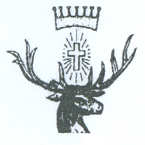
(The island's insignia. The stag because he was a hunter, the cross for Christianity obviously and the crown presumably because he was the eldest son of a duke.)
St Hubert
He was some rich bugger born around 626 who's dad was a French duke. He was a dead keen hunter and is the patron saint of hunters. He got religion after he was chasing some stag through the woods and it stopped and told him he was a naughty boy and to go off to church. (Which is liable to happen if you eat magic mushrooms before gallivanting about in the woods.) So then he does as ordered by the stag and gets religion and chucks over the life of wealth and luxury and does something churchy then carks it in 727.
Back to the Who's Who
When this Coghlan guy kicked it in 1872, he'd Willed the island to the Most Rev. Father Polding who was Arch Bishop of Sydney at the time. When he kicked it he left it to a Rev. Roger Vaughan and the Reverend Roger flogged it to a land agent called Francis Fahey in 1881 for £72 and Vaughan flogged it a few months later for £152 to some Sydney brickmaker called Collins. Collins sold it to Browne, Browne & Abbott and the bank got it in a mortgage foreclosure in 1905.
The bank subdivided it in 1906 and started selling it in 120 lots of "2 roods to 5 acres 2 roods". It had a "network of roads 66 feet wide" then but no canals yet. 18 lots sold between June 1914 and September 1924 so it wasn't exactly a hot property.
In 1947 some bloke called Swallow seems to've snapped up all the lots left and he sold 28 blocks between '47 and '52. In October 1961 all the lots he had left were bought up by some crowd calling themselves St Hubert's Island Pty Ltd. They seem to have been the last pair of hands the island went through. After that it was all private lots in the hands of residents.
A bridge over the Creek Cockle
Up to the seventies there was no permanent bridge or whatever to the island. There were some causeways going to Woy Woy via the unnamed islets and to Daley's Point and so on. A causeway, my Pocket Oxford tells me, is a "raised road across low or wet ground or water". Sand dredged up or dug up from somewhere no doubt, and dumped at low tide to make a cart-wide road across to the mainland. Which must've mucked the tidal flows about something cruel.
Anyways, in the late sixties work starts on The Rip Bridge. Which connects the Peninsula to Daley's Point. Daley's Point is pretty close to one end of the island so plans were drawn up and a ramp was built from Daley's down to the island and opened in 1971. The Rip Bridge was opened in 1974. With the bridge and the ramp it's about 15 minutes drive from Woy Woy station to St Hubert's.
I'm not sure when the canals went in. There's an early seventies photo in one of the library books showing a brand spanking new ramp and the canals built and a single house being built on a canal-front block of land. There's 3 or 4 established houses but they're in spots that would've been unaffected by the canal building. There's also a photo of four forties houses on Beachfront Parade. That's undated and so is the photo showing two houses, probably on what was eventually Beachfront.
That photo also shows a house and some other building on Riley's Island. Riley's was privately owned early on and the Rileys used it for boat building apparently. It was saved from a fate worse than death (being canal'd) by Paul Landa. He was the Minister for Something or Other and saved many a bit of wilderness from a grim death. I sat in one of his memorial parks at Pearl Beach.
In March 1788, Governor Phillip sussed out Broken Bay. I went on about this a bit when I walked Ettalong and Pearl Beach. As well as those two places the other place he landed in Brisbane Water was at St Hubert's. In 1988 (Australia's bicentennial of white settlement) there was a memorial to Phillip bunged up and a celebratory sausage sizzle put on at Long Arm Parade, complete with a costumed re-enactment of the landing. A newspaper report in 1988 says the monument was paid with a Bicentennial grant and the sausage sizzle paid for "by the sale of St Huberts spoons".
Governor Phillip's memorial
Plaque no 1.: "Australia 1788 - 1988 From the State Govt., Gosford City Bicentennial history Subcommittee & the St. Huberts Island Resisents Association an Australian Bicentennial Project To commemorate the nation's Bicentenary in 1988".
Plaque no 2.: "Monday 3rd March, 1788 When the tide had slacken'd we picked up and found several small inlets between mangroves on one of which island we stop'd and pitch'd the tents: had a very hard rain all the morning Lieut. Wm Bradley March, 1788".
Plaque no 3.: "Tuesday, 4th While the tents and clothes were drying... a crab was caught and proved very good AM, at day light proceeded up... we found natives all the way up. Lieut. Wm Bradley March, 1788".
Plaque no 4.: "This plaque was laid on the 3rd of March 1988 to commemorate the landing in this vicinity of Gov. Phillip, Lieut. Hunter and their party on 3rd March 1788".
(Biggest version)
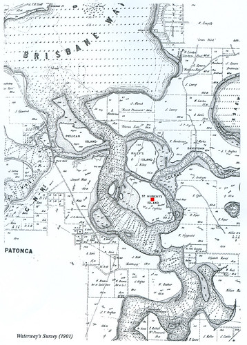
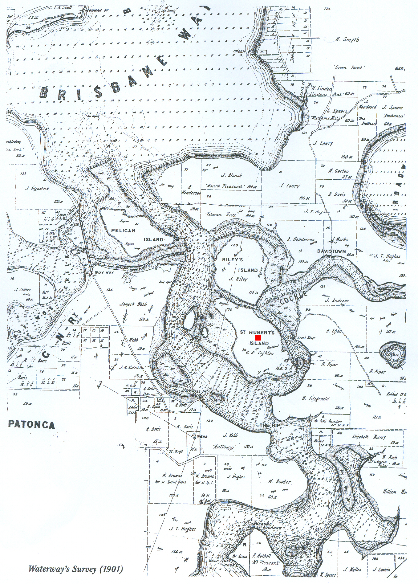
Waterman's Survey 1901. St Hubert's is the one with the red dot on it.
2 comments:
This is the kind of post you can really sink your teeth into! Great stuff. Cool map.
It seems amazing that ol' St. Hubert could have lived to 101 years old back in 8th century. He ought to be the patron saint of longevity as well as hunting.
Thank yer kindly.
Dead right (har har) about Hube. Must've been all that stag chasing in his younger years or summat.
Post a Comment